cptcatz
-
Posts
1,078 -
Joined
-
Last visited
Content Type
Profiles
Blogs
Forums
American Weather
Media Demo
Store
Gallery
Everything posted by cptcatz
-
2022 Atlantic Hurricane season
cptcatz replied to StormchaserChuck!'s topic in Tropical Headquarters
The 12Z GFS ensembles are still blasting the east coast... -
2022 Atlantic Hurricane season
cptcatz replied to StormchaserChuck!'s topic in Tropical Headquarters
Aaaand 06Z back to showing 3-1-1 in the MDR by end of August. -
2022 Atlantic Hurricane season
cptcatz replied to StormchaserChuck!'s topic in Tropical Headquarters
Looks like Euro/EPS and GFS/GFES are both in agreement that potentially three waves could develop by the end of August. Waves come off around Aug 20, 24, and another around the 29th that both models are seeing. I suppose we're gonna be sone quietness from ldub... -
2022 Atlantic Hurricane season
cptcatz replied to StormchaserChuck!'s topic in Tropical Headquarters
Here we go, the MDR is waking up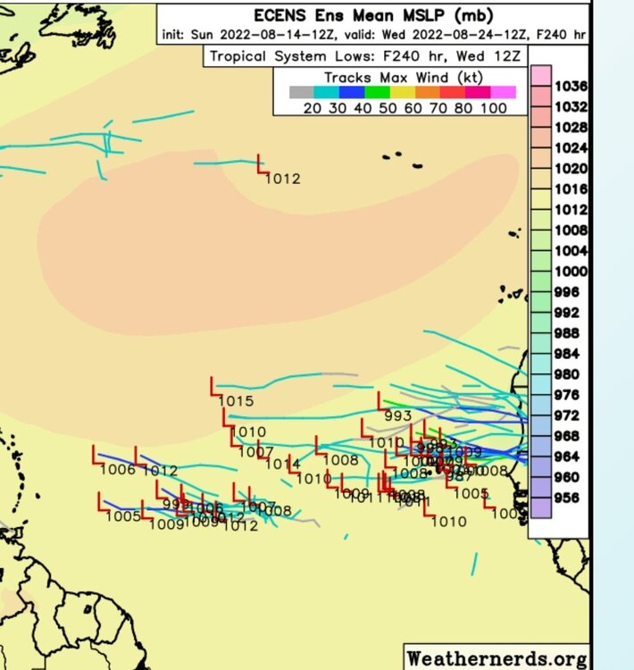
-
2022 Atlantic Hurricane season
cptcatz replied to StormchaserChuck!'s topic in Tropical Headquarters
12z euro sticking with that wave...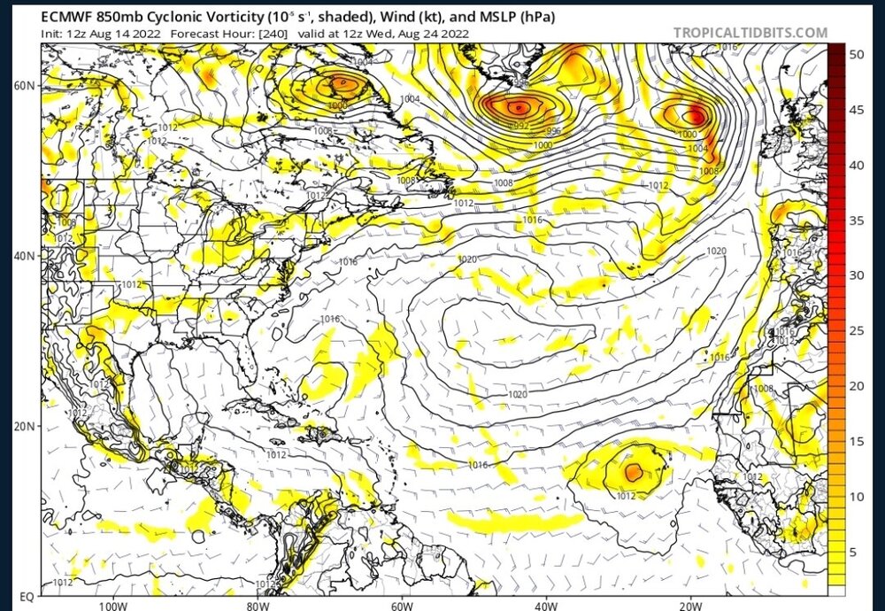
-
2022 Atlantic Hurricane season
cptcatz replied to StormchaserChuck!'s topic in Tropical Headquarters
Euro/EPS and CMC both seeing a solid wave emerging Africa in 10 days. Gotta see if they stick with it and if GFS gets on board, maybe this will finally be the start of the season.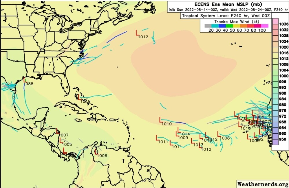
-
2022 Atlantic Hurricane season
cptcatz replied to StormchaserChuck!'s topic in Tropical Headquarters
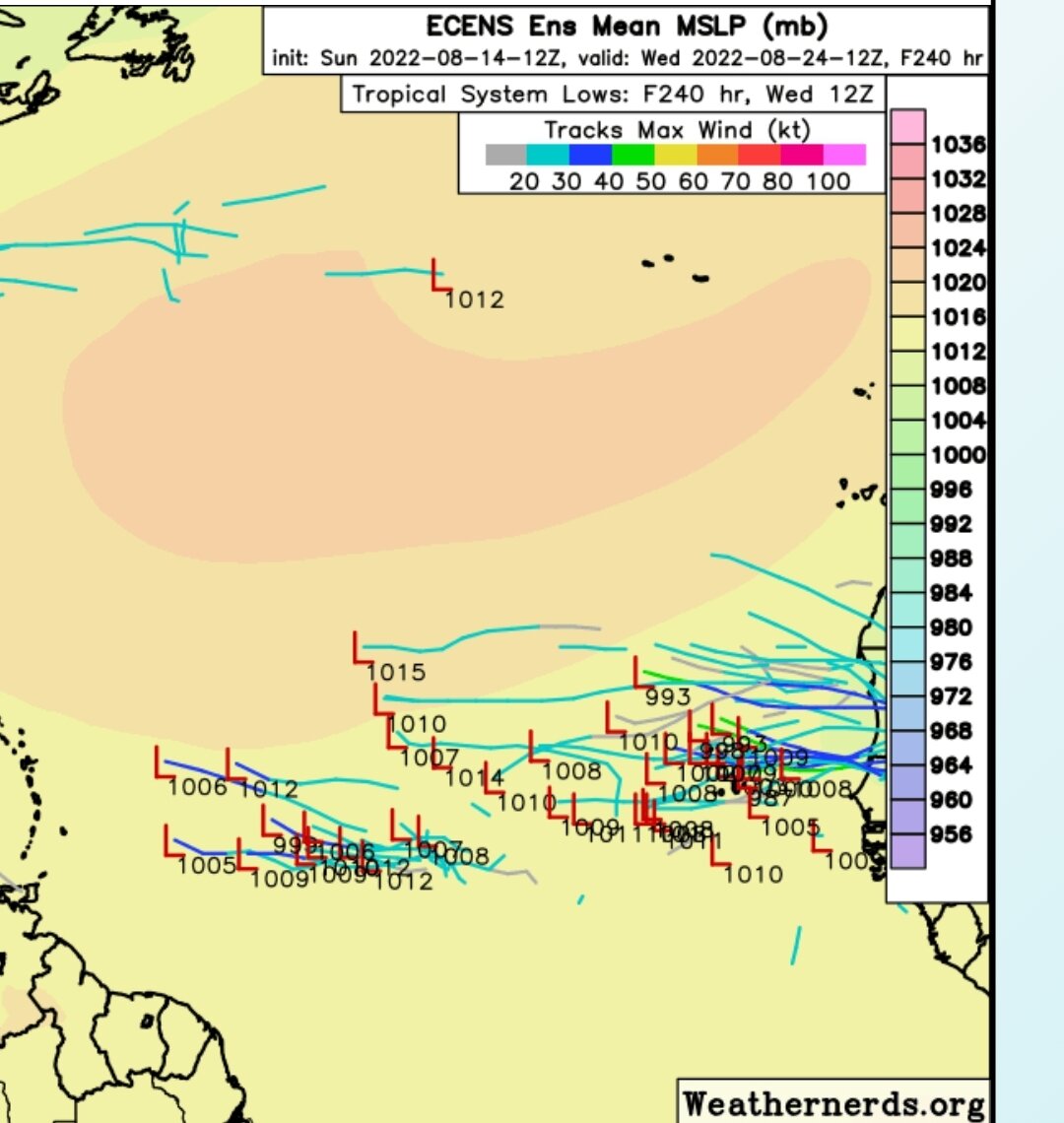
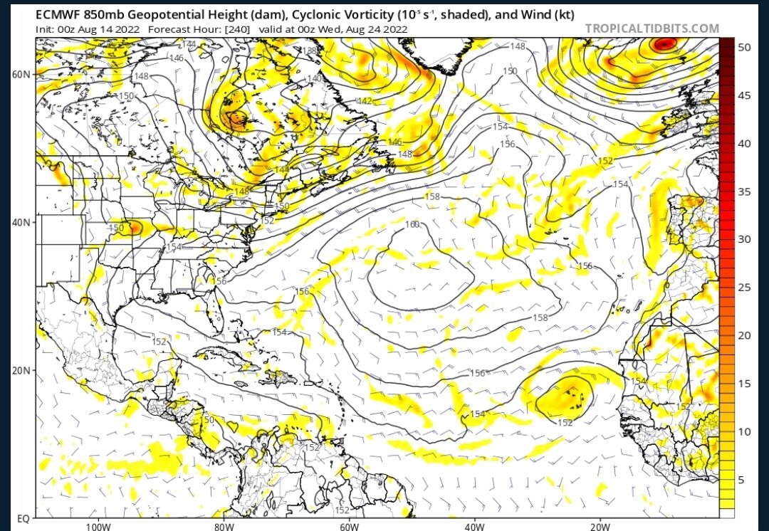
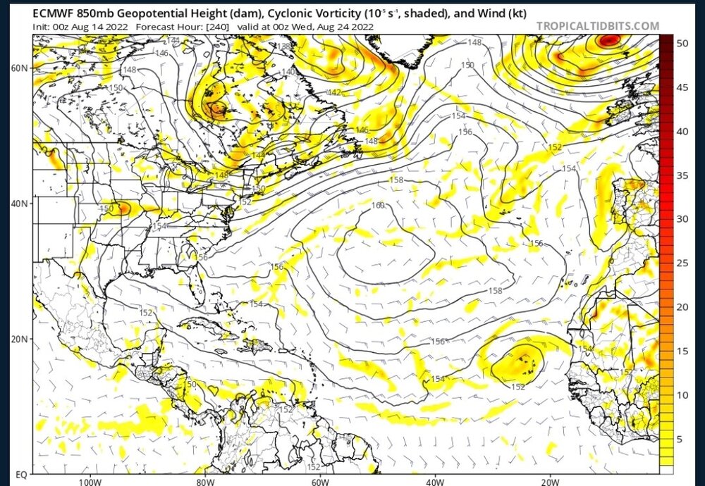
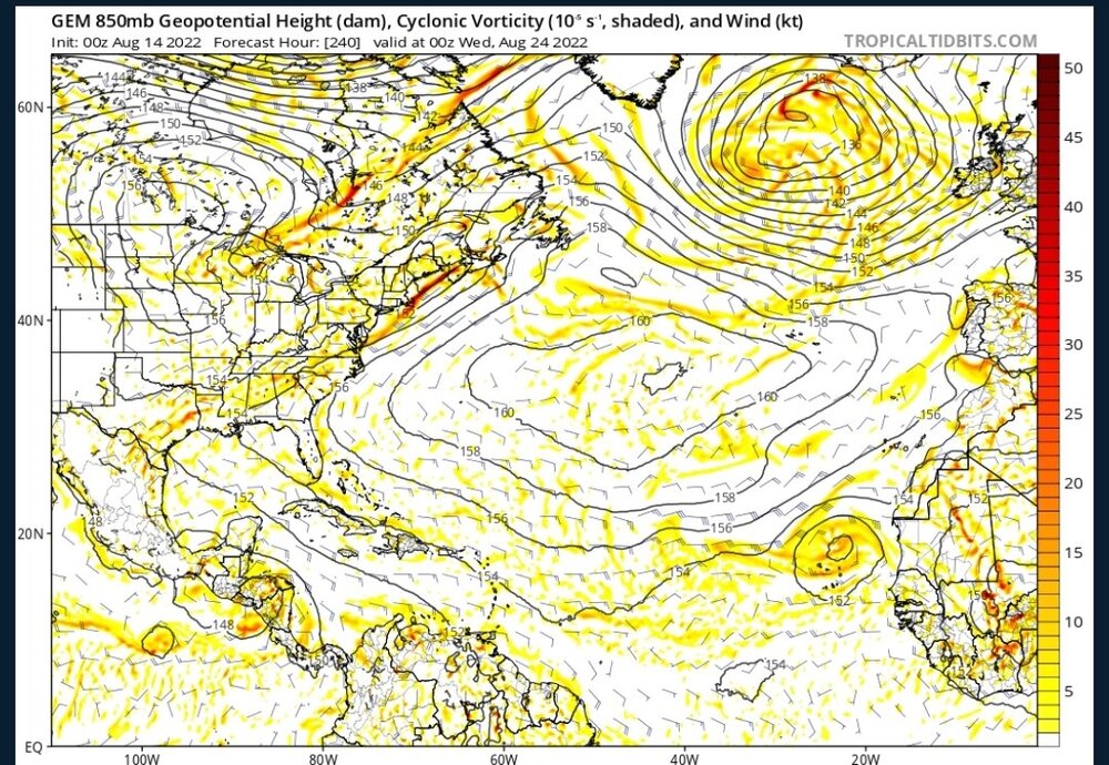
Now this might be the most interesting thing a model has shown this season, even if it may be 384 hours out... -
2022 Atlantic Hurricane season
cptcatz replied to StormchaserChuck!'s topic in Tropical Headquarters
No, August 8 is not the peak of the season. It's not even a month away from the peak of the season. Try again. -
2022 Atlantic Hurricane season
cptcatz replied to StormchaserChuck!'s topic in Tropical Headquarters
Why are any of us on this website if we don't enjoy watching the extremes of weather? The way I see it, it makes no difference what you root for since it has zero impact on what will happen. -
2022 Atlantic Hurricane season
cptcatz replied to StormchaserChuck!'s topic in Tropical Headquarters
Can't wait til ldub eats his/her words. I'm just gonna leave this post here from August 10, 2017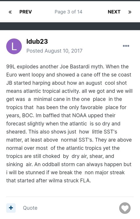
-
2022 Atlantic Hurricane season
cptcatz replied to StormchaserChuck!'s topic in Tropical Headquarters
lol I didn't think I come across too bullish. But... I'll do my part with a bullish response here. Models are starting to come into agreement that cyclogenesis will occur in about 4-5 days. Then you're talking about what conditions might look like in 10+ days. Models have zero idea what conditions look like 10 days down the road. Whenever I think of that, I always go back to Dorian. Here were the EPS 10 day ensembles: -
2022 Atlantic Hurricane season
cptcatz replied to StormchaserChuck!'s topic in Tropical Headquarters
Euro ensembles are picking up on it: GFS/CMC/Euro are all starting to pick up on the MDR wave as well. Could be tracking two systems next week. So much for your 0-0-0 August prediction. -
2022 Atlantic Hurricane season
cptcatz replied to StormchaserChuck!'s topic in Tropical Headquarters
With the tropics quiet for now, it's fun to look back at the older thread posts... August 10, 2017: August 11, 2017: -
2022 Atlantic Hurricane season
cptcatz replied to StormchaserChuck!'s topic in Tropical Headquarters
Here we go! Major into Mexico and another little something into Florida...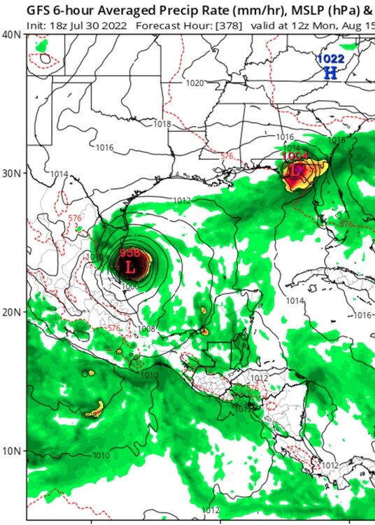
-
2022 Atlantic Hurricane season
cptcatz replied to StormchaserChuck!'s topic in Tropical Headquarters
What would (or did) ldub say at this point during the 1999 season? -
2022 Atlantic Hurricane season
cptcatz replied to StormchaserChuck!'s topic in Tropical Headquarters
GEFS is starting to hint at some Caribbean/Gulf action in mid August for a few runs now. How soon before ldub changes his 0-0-0 August predicition?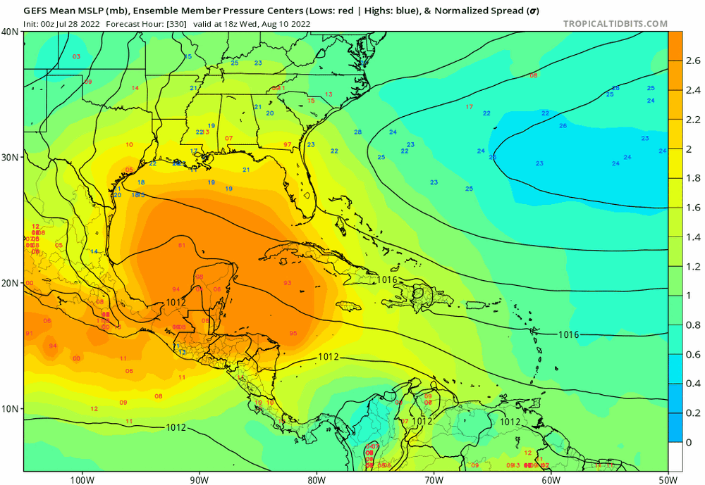
-
2022 Atlantic Hurricane season
cptcatz replied to StormchaserChuck!'s topic in Tropical Headquarters
I'm not making any prediction here, but for those writing off the season on July 27 needs to remember there are three months of peak season ahead of us and it only takes two months of hurricanes to make a 226.9 ACE season: -
2022 Atlantic Hurricane season
cptcatz replied to StormchaserChuck!'s topic in Tropical Headquarters
I wasn't following hurricanes back then but just taking a look at the wikipedia page, the 2000 season lived up to or outdid the forecasts. https://en.wikipedia.org/wiki/2000_Atlantic_hurricane_season#Pre-season_outlooks -
2022 Atlantic Hurricane season
cptcatz replied to StormchaserChuck!'s topic in Tropical Headquarters
Logic not even once. Statement #1 implies that MJO doesn't have as much bearing as people may think. Statement #2 implies that the MJO going negative will have a large bearing on the season. -
2022 Atlantic Hurricane season
cptcatz replied to StormchaserChuck!'s topic in Tropical Headquarters
For those responding to ldub, just remember he posted these posts in July/August 2020: -
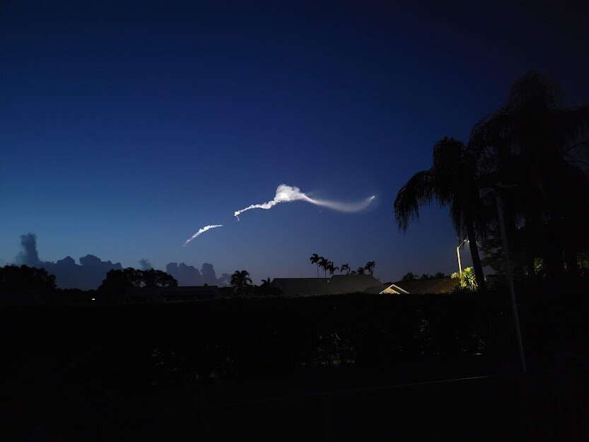
Yep, those Falcon9 launches at twilight are amazing. This was the view from my backyard.
-
2022 Atlantic Hurricane season
cptcatz replied to StormchaserChuck!'s topic in Tropical Headquarters
Quoting this to come back to it to make you look like a fool in October... -
That video isn't in daylight. That was the January 31 launch which launched at 6:11pm, about 10 minutes after sunset, I watched it from my backyard and it was fantastic (although the best view still goes to the Inspiration4 launch). Space/rockets interests me just as much as weather and I watch every single rocket launch from here in South Florida. After numerous tries of trying to see daylight launches in cloudless skies, I eventually gave up as they are simply not visible from here. And since the Astra rocket is 1/4 the size of a Falcon 9 and today's launch being at 1:40pm, there was a 0% chance of seeing it from Miami with the naked eye.
-
It did go east. The Astra rocket was not visible from Miami.
-
Hate to break it to you but that's an airplane. You can't see Falcon 9 rockets during the day from Miami, let alone this Astra rocket which is a quarter of the size.