cptcatz
-
Posts
1,077 -
Joined
-
Last visited
Content Type
Profiles
Blogs
Forums
American Weather
Media Demo
Store
Gallery
Everything posted by cptcatz
-
2022 Atlantic hurricane season whining/banter
cptcatz replied to GaWx's topic in Tropical Headquarters
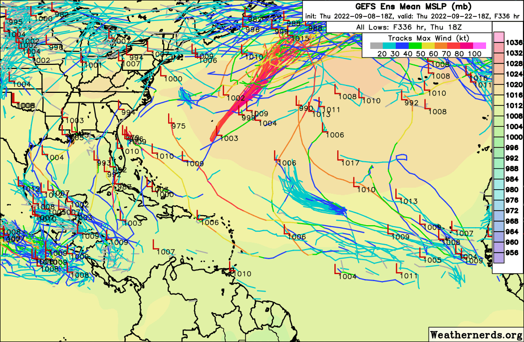
Pretty amazing how boring the 336 hour GEFS happy hour run of September 8 is. The only little interesting thing I see are the handful of members rising up from the western Caribbean heading towards Cuba/Florida. Could be a sign of what's to come?
-
2022 Atlantic Hurricane season
cptcatz replied to StormchaserChuck!'s topic in Tropical Headquarters
And the 12z Euro just went completely poof on the current lemon. It's still developing the wave behind that one but I'm sure it'll go poof on that one too in a few days. -
2022 Atlantic hurricane season whining/banter
cptcatz replied to GaWx's topic in Tropical Headquarters
As I mentioned in the other thread, are hurricanes that don't hit any different than the great red spot on Jupiter? I would say not really... -
2022 Atlantic hurricane season whining/banter
cptcatz replied to GaWx's topic in Tropical Headquarters
What a borefest so far -
2022 Atlantic Hurricane season
cptcatz replied to StormchaserChuck!'s topic in Tropical Headquarters
lol it should be more like "Cat 5 mid atlantic hurricane" on the right and "60mph tropical storm landfalling on the east coast" on the left. -
2022 Atlantic Hurricane season
cptcatz replied to StormchaserChuck!'s topic in Tropical Headquarters
I'll speak for myself here but I would much rather see the two middling tropical storms threatening the US. I mean, hurricanes in the middle of the Atlantic are only useful as pretty colors on a satellite image. I mean, have you guys seen that impressive storm on Jupiter? According to wikipedia it's been active for at least 357 years and produces winds up to 268 mph. What an impressive ACE score that produces! -
2022 Atlantic Hurricane season
cptcatz replied to StormchaserChuck!'s topic in Tropical Headquarters
I am, and they're showing basically nothing going out to late September. GFS has zero cyclogenesis through 384 hours, and all Euro has is fantasy storms way out east which it continues to gradually drop as time moves up which it's been doing all year. Euro's fantasy eastern-MDR storms are worse than GFS's Caribbean fantasy storms. Outside of the Caribbean the GFS has been pretty spot on this year and it's showing a dead rest of September. -
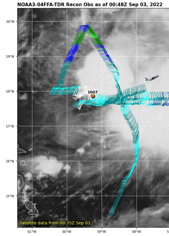
Gotta say the number of recon flights is impressive. I guess they're making up for all the missed flights in August? 96 knot flight level wind just recorded.
-
2022 Atlantic Hurricane season
cptcatz replied to StormchaserChuck!'s topic in Tropical Headquarters
Yeah September is looking pretty dead but you still can't rule out one or two October western Caribbean monsters ala Michael/Wilma/Matthew/Sandy. -
2022 Atlantic Hurricane season
cptcatz replied to StormchaserChuck!'s topic in Tropical Headquarters
12z GFS has zero tropical cyclogenesis and CMC dropped this leading wave as well along with the 00z Euro. This season is getting pretty laughable. -
2022 Atlantic Hurricane season
cptcatz replied to StormchaserChuck!'s topic in Tropical Headquarters
I didn't say I wanted damage, actually I specifically said I didn't want damage... -
2022 Atlantic Hurricane season
cptcatz replied to StormchaserChuck!'s topic in Tropical Headquarters
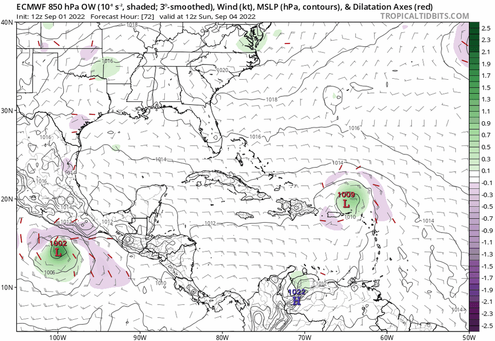
Not sure if it matters much at this point but it looks like almost all of the members end up curving out to sea.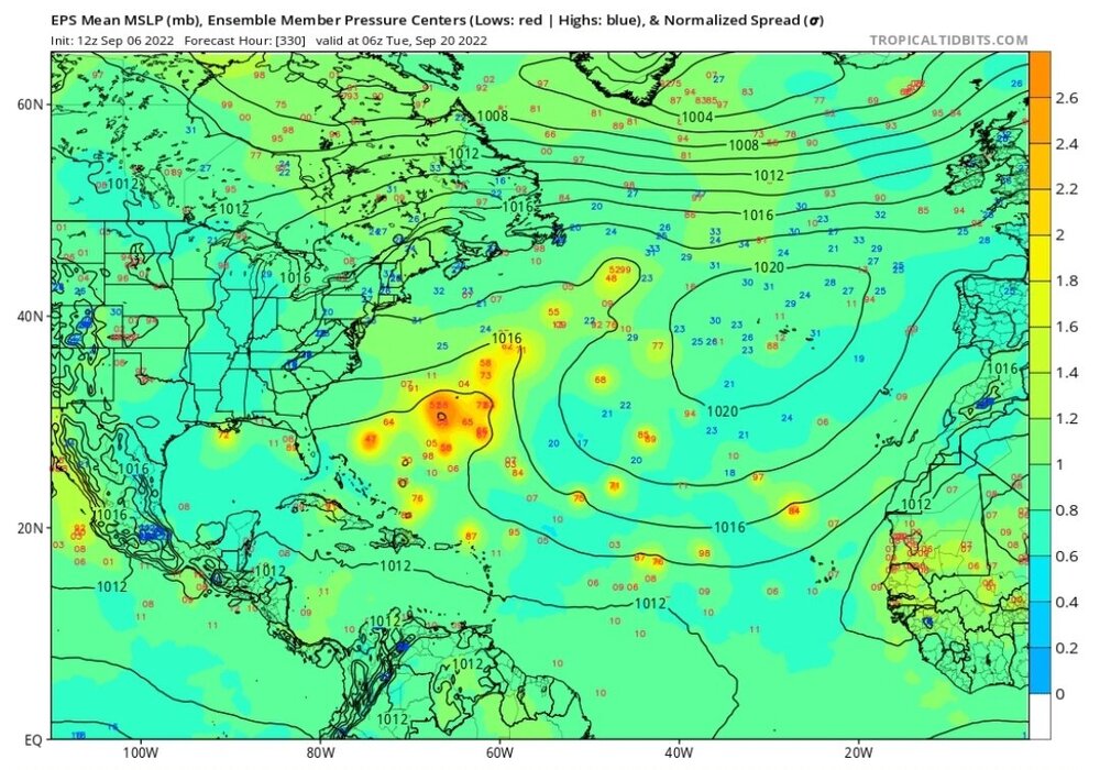
-
2022 Atlantic Hurricane season
cptcatz replied to StormchaserChuck!'s topic in Tropical Headquarters
I'm a homeowner in Palm Beach County, Florida and I am rooting for a solid cat 1 strike in my area. I'd take anything that doesn't cause financial damage to my house (or my collection of fruit trees in my backyard). But a good 70-80 mph storm causing some power outages I'd take (my in-laws live down the street with a whole-house generator so not worried about power outages). Of course if a Dorian-style major hurricane does strike my area and kill my fruit trees and cause damage to my house, I would be pissed but I wouldn't regret my wishcasting for a storm since that wishcasting had zero impact on the MH strike. So yeah, I'll be the first to say I hope for some good landfalling hurricanes. -
2022 Atlantic Hurricane season
cptcatz replied to StormchaserChuck!'s topic in Tropical Headquarters
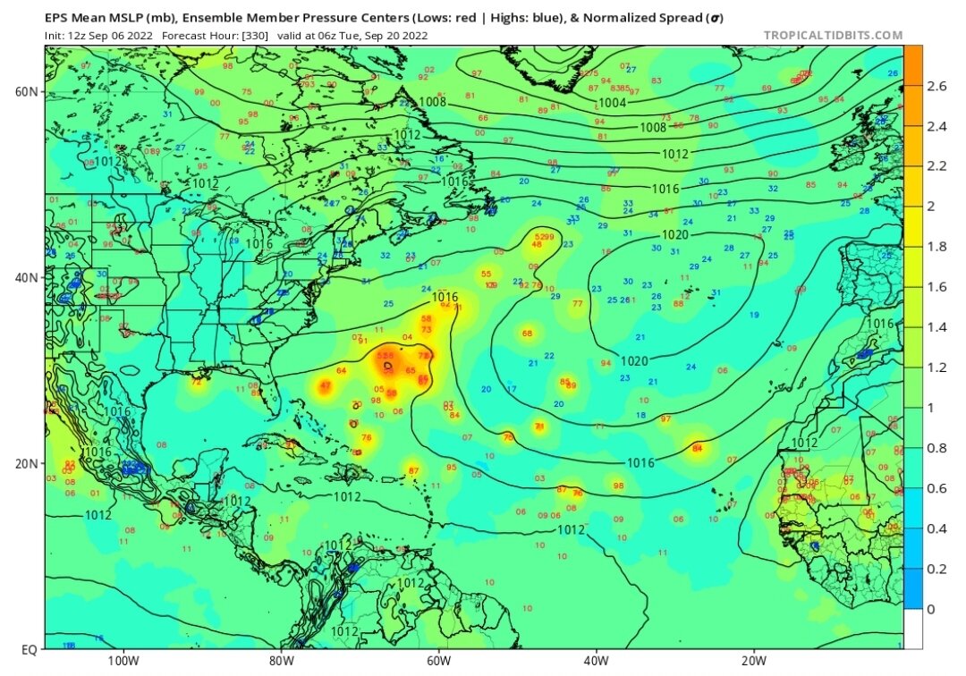
Quite a look on the 12z EPS. Got Earl going all over the place... while unlikely, a loop back to the US is on the table. Then a red hot wave coming off Africa at the end of the run quickly turning into a MH.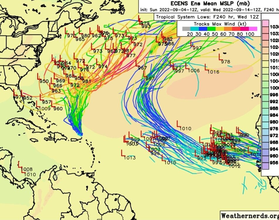
-
2022 Atlantic Hurricane season
cptcatz replied to StormchaserChuck!'s topic in Tropical Headquarters
Agreed. A flip of the switch implies that bad conditions have switched to good conditions, even close to hyperactive conditions as the forecasts called for. We're not seeing that. We're seeing terrible tropical conditions in the very height of peak conditions which had produced two sloppy marginal storms. And looking at the models into mid September shows nothing changing as well. Of course mid September through October could be active but I don't see any switches flipped currently or in the next week or two on the models. -
2022 Atlantic Hurricane season
cptcatz replied to StormchaserChuck!'s topic in Tropical Headquarters
Maybe the most interesting thing that happens in the Atlantic this season will be Earl's impact on Europe... -
56 knot wind and 998 mb on this pass. Really outperforming what every model has been showing.
-
Just a little note: recon found the center south of 18N while the NHC and all the models had at north of 18N. Wonder if that will change anything.
-
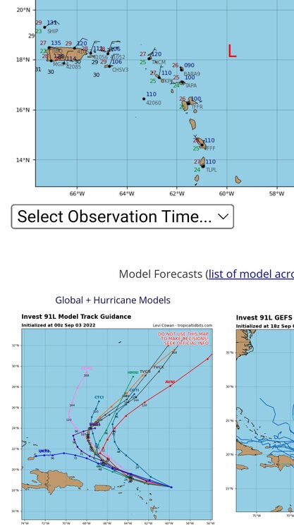
Euro coming in still further to the south. Will be interesting to see where it ends up on this run.
-
CMC is getting on board with Euro/EPS and UKMET. Maybe it's just my wishcasting but if this thing stays a mess until the Bahamas, it could come close to CONUS. This could actually be a very similar origin story as Katrina.
-
Looks like there a couple that do loops ala Jeanne or Betsy.
-
2022 Atlantic Hurricane season
cptcatz replied to StormchaserChuck!'s topic in Tropical Headquarters
00z Euro and CMC both with a hurricane in the central MDR at day 10. Maybe this will be the one?
-
It's not looking terrible on satellite and 18z Euro/EPS did track a bit more southward...
-
2022 Atlantic Hurricane season
cptcatz replied to StormchaserChuck!'s topic in Tropical Headquarters
Yeah we're still over a month away from the Wilma-Matthew-Michael-Sandy tracks. No reason to think we can't get one or more of those tracked storms. -
Hurricane Grace just last year. Big miss by the early models.