cptcatz
-
Posts
1,077 -
Joined
-
Last visited
Content Type
Profiles
Blogs
Forums
American Weather
Media Demo
Store
Gallery
Everything posted by cptcatz
-
Ian had the biggest lead up since Irma. Go check out the Ian thread again... we were discussing a major hurricane in the Gulf while it was still an invest over a week before landfall.
-
The convection is quite impressive and much further east than models had been showing. Watching these trends closely here in south Florida.
-
Recon and visual satellite both showing the center is a full 2 degrees west of where NHC has it...
-
2023 Atlantic Hurricane season
cptcatz replied to Stormchaserchuck1's topic in Tropical Headquarters
Interesting little shift west on the 18z EPS... -
2023 Atlantic Hurricane season
cptcatz replied to Stormchaserchuck1's topic in Tropical Headquarters
90L is looking nice this morning. Will be interesting to see how far west it tracks. I feel like models don't have a good handle on it. -
2023 Atlantic Hurricane season
cptcatz replied to Stormchaserchuck1's topic in Tropical Headquarters
Quite a few of the GFS runs have been showing a CAG like storm forming in the western Caribbean. CMC has been showing it a lot too and now EPS is hinting it at. Where it goes from there is a toss up but the fact that it forms on many models is what's important. -
Anyone know if recon will be flying into it?
-
2023 Atlantic Hurricane season
cptcatz replied to Stormchaserchuck1's topic in Tropical Headquarters
12z GFS, CMC, and Euro are basically telling us we have no idea what's gonna happen. Jeez can we get some model consistency here please? -
2023 Atlantic Hurricane season
cptcatz replied to Stormchaserchuck1's topic in Tropical Headquarters
18z EPS still showing four distinct clusters within 144 hours -
2023 Atlantic Hurricane season
cptcatz replied to Stormchaserchuck1's topic in Tropical Headquarters
Nice post as right after that the 12z EPS blew up. We'll see if it sticks https://twitter.com/HurricaneManWx/status/1687931125040070656 -
Structure looks nice but all models have it go poof as soon as it enters the Caribbean. If the NHC is right and it maintains at a 75-80 mph hurricane through the Caribbean, they would get mad respect.
-
2023 Atlantic Hurricane season
cptcatz replied to Stormchaserchuck1's topic in Tropical Headquarters
This system in the western Caribbean is what the GFS has been saying hits Florida as a hurricane for the last 2 weeks. It certainly looks impressive right now. It'll be interesting to watch in real time. -
2023 Atlantic Hurricane season
cptcatz replied to Stormchaserchuck1's topic in Tropical Headquarters
That's quite a look for June 11. This is gonna be an interesting season... -
1) Sandy made landfall at 945 mb 2) Sandy was 1,100 miles wide 3) Sandy pushed the surge into New York Bay which is one of the largest bays in the world and naturally incredibly surge prone. There is nothing like that around where Nicole is going. To sum it up, this is nothing like Sandy.
-
Looks like it's trying to pop some convection on the western eyewall. Needs it to stick if it's gonna intensify some more.
-
Wow that recon pass really just ramped things up quick. On the verge of being a hurricane now.
-
Anyone know when the next low level recon is?
-
Someone tell me if I'm crazy but I'm seeing the LLC now moving just EAST of due south...
-
The last few frames of satellite looks like the center is moving due south and convection is trying to pop right there.
-
It's going to be a top heavy storm with all the bad weather to the north. Regardless of what happens Orlando is gonna get some nasty weather. Canceling your trip depends on what you plan on doing there.
-
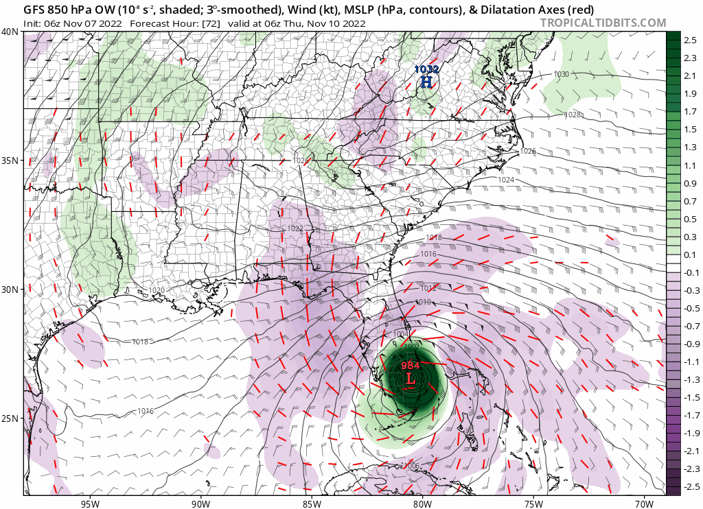
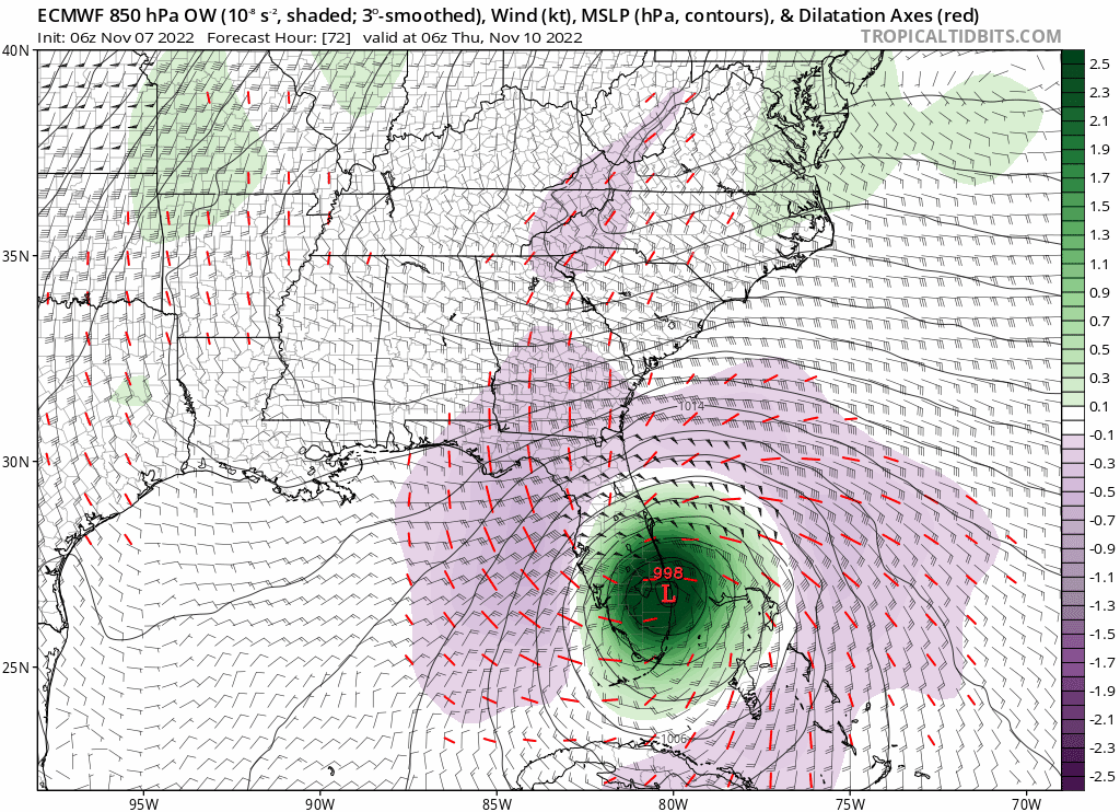
06Z GFS shows landfall in Boca Raton (where I live) at 984mb vs Euro shows landfall in West Palm Beach at 998mb. If you split the difference you get landfall in Boynton Beach at 991mb.

-
At least the track is pretty locked in. At this point in Ian's life the GFS was showing a panhandle/Alabama storm while Euro/UK were showing Naples to Tampa.
-
I think it's a given that Wednesday and Thursday will be a washout at the very least. There could definitely be bigger issues if this thing is on the stronger side of the models...
-
^I suppose a 977mb storm would be the worst case scenario for a mid-November sloppy subtropical system... Anyways, the ensembles are just as bullish as the GFS operational.
-
All year GFS and Euro have been meeting half way. Now with GFS showing 982mb and Euro showing 1006mb, mark my words here that it will be 994mb.