cptcatz
-
Posts
1,077 -
Joined
-
Last visited
Content Type
Profiles
Blogs
Forums
American Weather
Media Demo
Store
Gallery
Everything posted by cptcatz
-
2023 Atlantic Hurricane season
cptcatz replied to Stormchaserchuck1's topic in Tropical Headquarters
Last two runs of GFS going all in with a cat 5 in the western Caribbean -
2023 Atlantic Hurricane season
cptcatz replied to Stormchaserchuck1's topic in Tropical Headquarters
It was. Look through the first couple pages of this thread. A lot of talk about recurves and analogs to 2010 which had similar tracks. -
2023 Atlantic Hurricane season
cptcatz replied to Stormchaserchuck1's topic in Tropical Headquarters
Interesting because if you asked somewhat what to expect with an El Nino and record hot Atlantic, that's exactly what you'd expect. -
2023 Atlantic Hurricane season
cptcatz replied to Stormchaserchuck1's topic in Tropical Headquarters
Both areas, the MDR wave and the east coast system, are looking juicy this morning. Surprising neither are invests yet. -
2023 Atlantic Hurricane season
cptcatz replied to Stormchaserchuck1's topic in Tropical Headquarters
18z GFS weenie run bringing a major hurricane into Norfolk at a right angle, front right quadrant going into Chesapeake Bay... -
2023 Atlantic Hurricane season
cptcatz replied to Stormchaserchuck1's topic in Tropical Headquarters
GFS can't make up its mind with Nigel. After that crazy 00z run, it follows up with 06z where it doesn't even make it west of Bermuda. -
Track kinda, but Henri was a minimal hurricane at its peak and made landfall as a tropical storm. This could impact that area as an equivalent cat 2 hurricane with a massive windfield. I know it's weenie frowned upon here to bring up the certain S storm as comparison, but it seems that's the most comparable storm in recent history.
-
GFS hour 132 looks like it's hooking west in Boston. Ugh maybe I shouldn't watch this frame by frame.
-
Icon, CMC, GFS all west at 12z. Maybe yesterday's euro was on to something?
-
Recon showing its intensifying. Pressure down to 951. Starting to look better on satellite.
-
2023 Atlantic Hurricane season
cptcatz replied to Stormchaserchuck1's topic in Tropical Headquarters
00z GFS weenie run, basically worst case scenario for the mid Atlantic -
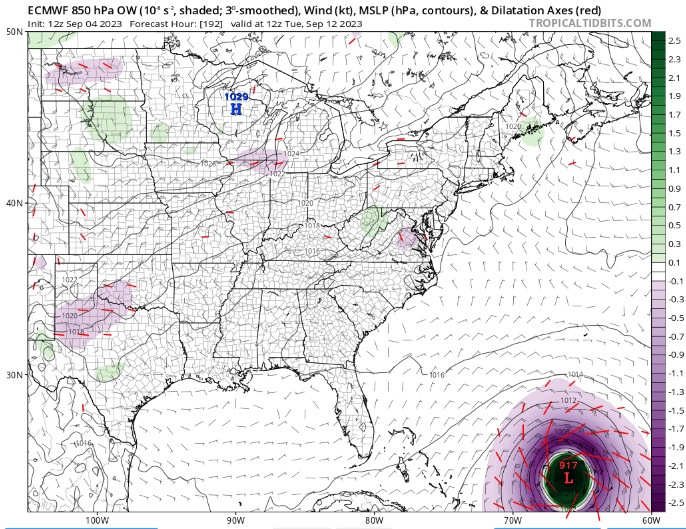
18z Euro still brings at down to 917 mb...
-
2023 Atlantic Hurricane season
cptcatz replied to Stormchaserchuck1's topic in Tropical Headquarters
Kinda interesting that it seems odds are quite good that Nova Scotia will get some hurricane-like impacts from Lee. In the last 4 years, Lee will be the 4th (post) tropical cyclone to make landfall on Nova Scotia, along with Dorian, Teddy, and Fiona. Also interesting is that all four storms peaked at cat 4 or 5. -
2023 Atlantic Hurricane season
cptcatz replied to Stormchaserchuck1's topic in Tropical Headquarters
This time next week should look interesting
-
12z Euro initializing at 984, steady for the next 24 hours, and still brings it down to 924 north of Puerto Rico, a difference of 60 mb. With it actually being 942 right now, does that mean it really gets down to 882?
-
Lee is about to blow open the hurricane/MH days stat. Looks like all those bullish seasonal forecasts will verify.
-
If this were to verify, i assume that would be catastrophic surge into Boston harbor?
-
Sounds like then it would show a 880mb storm riding up the east coast merging with a polar vortex causing a blizzard with 170 mph winds.
-
2023 Atlantic Hurricane season
cptcatz replied to Stormchaserchuck1's topic in Tropical Headquarters
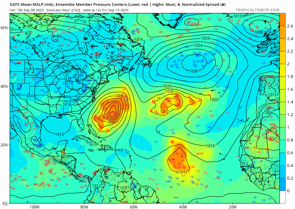
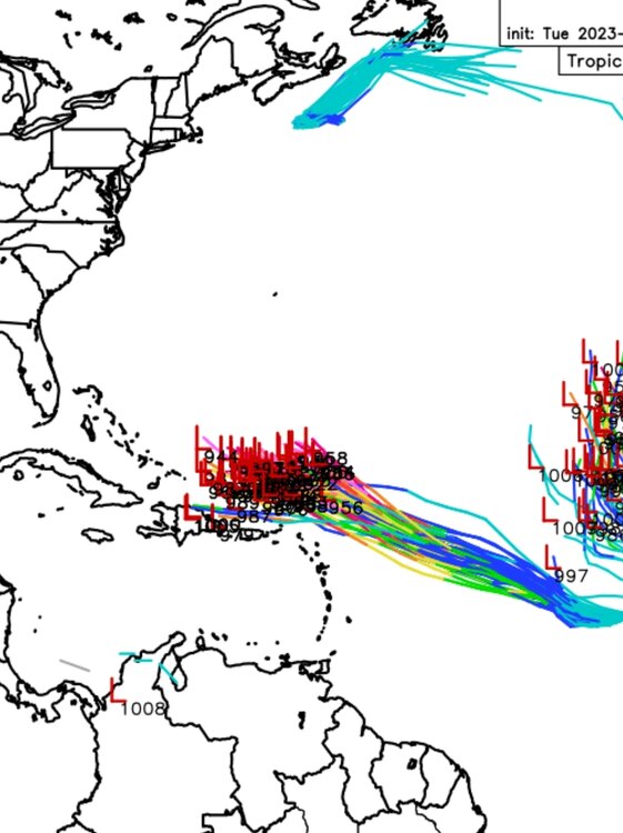
All major models now showing yet another potentially strong CV storm about a week behind Lee, NOT the current NHC marked orange. Looks like we're getting our answer of which will win the El Nino vs hot Atlantic... -
18z euro ensembles definitely more sw than previous runs...
-
Yeah, still, it's not often you see Euro going to 917 in a long range forecast. This thing is gonna be a quite something.
-
-
06z GFS decimates the northeast...
-
18z GFS with a carbon copy of Floyd
-
2023 Atlantic Hurricane season
cptcatz replied to Stormchaserchuck1's topic in Tropical Headquarters
12z euro brings this down to 935mb. That's pretty unheard of from euro this far out.