cptcatz
-
Posts
1,077 -
Joined
-
Last visited
Content Type
Profiles
Blogs
Forums
American Weather
Media Demo
Store
Gallery
Everything posted by cptcatz
-
2024 Atlantic Hurricane Season
cptcatz replied to Stormchaserchuck1's topic in Tropical Headquarters
Lol. "Don't look at long range operational runs!" "But check out this euro operational run 10 days out!" -
2024 Atlantic Hurricane Season
cptcatz replied to Stormchaserchuck1's topic in Tropical Headquarters
While we wait for the season to do something, I figure I'll share my newest video highlighting the top 10 hurricanes to hit Florida: -
2024 Atlantic Hurricane Season
cptcatz replied to Stormchaserchuck1's topic in Tropical Headquarters
Not really. Maybe in the MDR but October is when development pushes west in the Caribbean and GOM. Look at Wilma, Sandy, Michael, Matthew, Delta, Zeta. -
2024 Atlantic Hurricane Season
cptcatz replied to Stormchaserchuck1's topic in Tropical Headquarters
Last two GFS runs finally had something to look at long range. Maybe we'll see more stuff pop up on today's runs. Kinda crazy that it's August 20 in a forecasted hyperactive season and there's basically nothing on the horizon. I definitely can see october being busy based on the last 5 or so years. -
2024 Atlantic Hurricane Season
cptcatz replied to Stormchaserchuck1's topic in Tropical Headquarters
I hate to pull an ldub here but I'm itching to see something else on the long range models. Strange that all models now reach to the end of August and there's still nothing on the horizon after Ernesto. This season is definitely impressive with assuming Ernesto makes MH, we'd be at 5/3/2 by mid August, but I'm still not seeing the upper 20's named storms as many predicted. -
18z gfs with a bullseye on Bermuda. If you look closely you can see the island inside the eye.
-
Dude, Bermuda is a tiny island alone in the middle of the Atlantic Ocean. No one has any idea right now if it will hit it or pass by safely. Might be best to take a breather and just watch what happens.
-
12z GFS nails Bermuda, icon brushes it as a 940 storm. I think impacts to Bermuda could be the story with this one.
-
Overnight everything moving east, seems to be a clear OTS path. Could have a major hurricane getting close to Bermuda though.
-
Because every model is showing it being a miss. You're seeing what we're seeing, right? Wish casting won't make it turn the other way.
-
2024 Atlantic Hurricane Season
cptcatz replied to Stormchaserchuck1's topic in Tropical Headquarters
What's your point? GFS didn't show 98L developing until three days ago (Aug 7, 12z) and it looks like that will likely be a mjor hurricane. GFS long range doesn't know how to forecast cyclogensis and means nothing. -
2024 Atlantic Hurricane Season
cptcatz replied to Stormchaserchuck1's topic in Tropical Headquarters
Icon showing two MDR systems a week from now. Let's see if GFS and CMC follow suit. -
2024 Atlantic Hurricane Season
cptcatz replied to Stormchaserchuck1's topic in Tropical Headquarters
Classic ldub post of canceling the season in early August, never realizing that climatology ramps up in late August. -
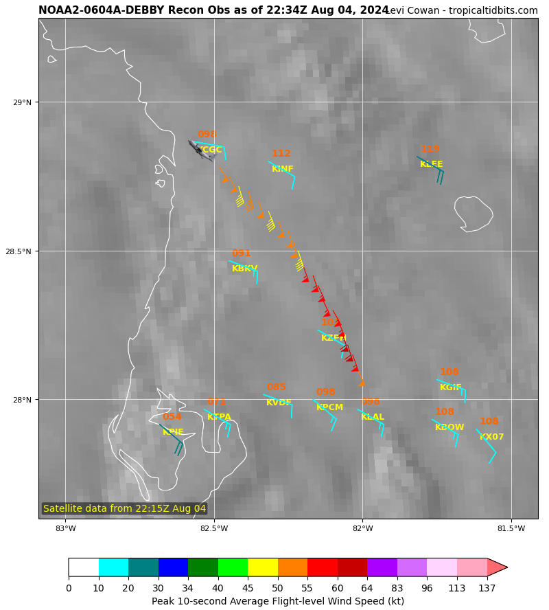
AF recon just made a proper center pass. 986 extrap pressure. There you go.
-
Yeah, radar with the eye now makes it easy to see it's direction. Definitely northeast. This path looks like it would take it between Ocala and Gainesville.
-
Recon taking off in a tropical storm...

-
Just got woken up to a tornado warning here in Boca Raton. Nasty looking outer band squall line about to move through.
-
2024 Atlantic Hurricane Season
cptcatz replied to Stormchaserchuck1's topic in Tropical Headquarters
GEFS 9 days out -
Hell yeah, a NOAA plane just took off from Lakeland... that should be in the storm in no time. The AF plane from Biloxi should be there a little bit after. Hopefully they are fully fueled and can stay in for a while. Will be interesting to see how it strengthens from pass to pass.
-
Agreed. This just has the look of a storm about to take off. Lots of hot towers going up right now.
-
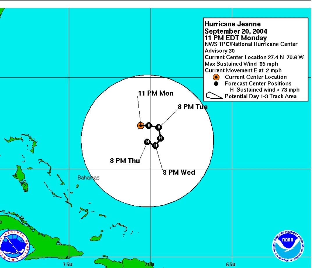
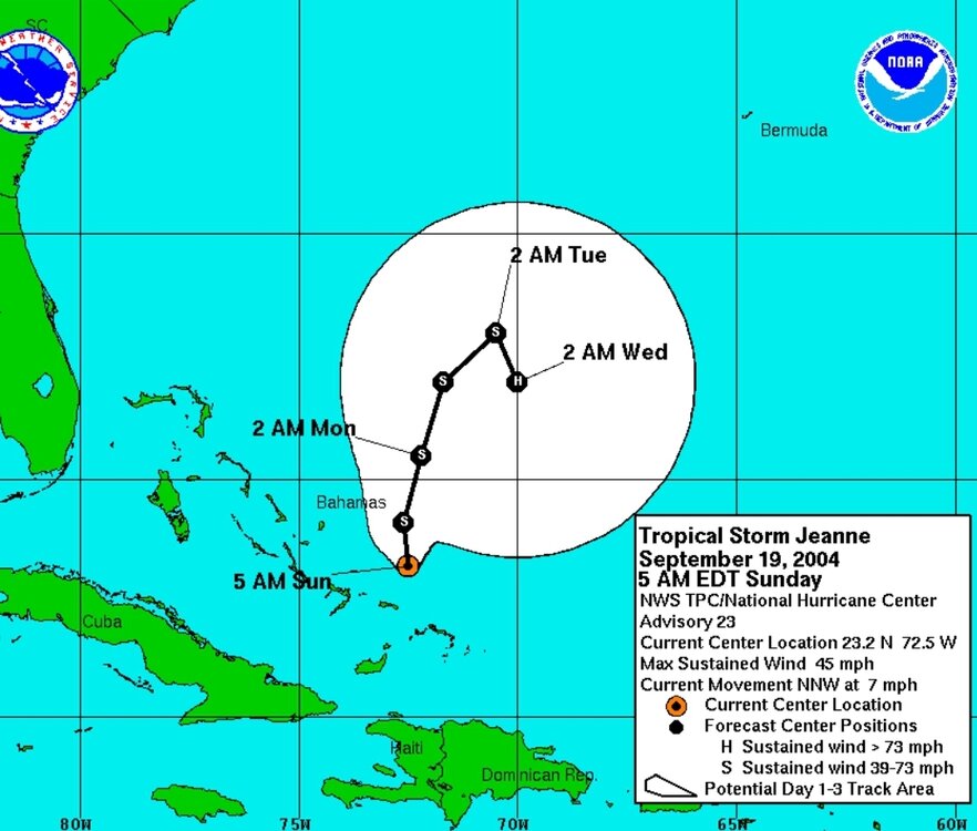
Jeanne had some gnarly turns

-
I'm not sure why this is a weenie take. The storm has a clear low level center with convection popping overhead, and will be traversing some of the hottest water in the world right now for the next 400 miles, along with what appears to be good atmospheric conditions. This along with GFS showing a landfall pressure of 983, I think cat 2 is clearly on the table right now.
-
Convection popping right over the low level center right now. I think it's off to the races. Wouldn't be surprised to see this pushing cat 2 at the Florida big bend landfall.
-
2024 Atlantic Hurricane Season
cptcatz replied to Stormchaserchuck1's topic in Tropical Headquarters
Not only the current wave in the central Atlantic, but both Euro and GFS are also picking up on the wave behind that too, also heading into the Caribbean. That's a good number of long range ensemble members showing development with very few showing an out to sea curve. Ominous look at only mid-August...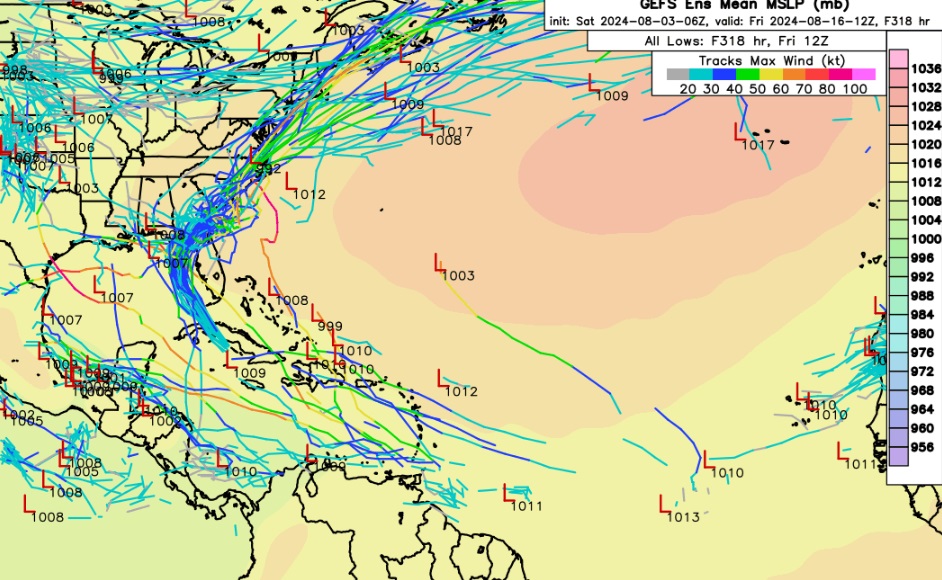
-
But Cuba is so narrow there a quick moving storm should only spend a couple hours traversing it. Look at Ian... it went over the western part of Cuba and barely made a blip.