George BM
-
Posts
3,048 -
Joined
-
Last visited
Content Type
Profiles
Blogs
Forums
American Weather
Media Demo
Store
Gallery
Everything posted by George BM
-
Mid-Atlantic forum winter 2021/22 snow totals thread
George BM replied to North Balti Zen's topic in Mid Atlantic
Herndon, VA 11/30/2021: T 1/03/2022: 6.0" 1/07/2022: 4.8" 1/16-17/2022: 2.8" 1/20/2022: T 1/28/2022: 0.8" ... Total as of January 30, 2022: 14.4" -
January 28-29 2022 Miller abcdefu Storm Obs/Discussion
George BM replied to mappy's topic in Mid Atlantic
Good morning weather weenies! I'm pretty happy about all the great reports and pics coming in from up north. Hopefully this band can develop into a surprise 6"+/hr thundersnow band that buries all of us and our worries under 2-3'+ of snow! Now you all know what to do. WEENIE ME UP! ... 33/17 at IAD under mainly cloudy skies at IAD atm. -
January 28-29 2022 Miller abcdefu Storm Obs/Discussion
George BM replied to mappy's topic in Mid Atlantic
31/18 under overcast skies at IAD. -
@DDweatherman
-
Morning lows: IAD: 12F (coldest of the season) DCA: at least 17F(have to see intrahour) BWI: at least 15F(have to see intrahour)
-
I like the snow squall that the 3kNAM is selling.
-
Appetizer thread--to track the sunday clipper and the tuesday slopsh%T
George BM replied to Ji's topic in Mid Atlantic
The 3km NAM shows a nice snow squall moving through from NW to SE. Soundings show steepening low-level lapse rates as the disturbance moves through the region leading to some 0-50j/kg MUCAPE (generally below 700mb) on this model.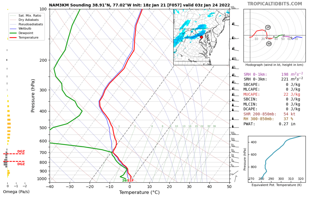
-
*Adds "Apocalyptic Frost Quake" to a certain list.* 17/1 at IAD this morning. DCA into the teens again (down to at least 19F).
-
Thursday 1/20/22 Stat Padder Discussion and Observations
George BM replied to stormtracker's topic in Mid Atlantic
What direction does your back and front yard face? -
Thursday 1/20/22 Stat Padder Discussion and Observations
George BM replied to stormtracker's topic in Mid Atlantic
URGENT - WINTER WEATHER MESSAGE National Weather Service Baltimore MD/Washington DC 109 PM EST Wed Jan 19 2022 DCZ001-MDZ011-013-014-016-504-506-508-VAZ052>056-502-200215- /O.NEW.KLWX.WW.Y.0008.220120T1100Z-220120T1800Z/ District of Columbia-Southern Baltimore-Prince Georges- Anne Arundel-Charles-Central and Southeast Montgomery- Central and Southeast Howard-Southeast Harford- Prince William/Manassas/Manassas Park-Fairfax- Arlington/Falls Church/Alexandria-Stafford-Spotsylvania- Southern Fauquier- 109 PM EST Wed Jan 19 2022 ...WINTER WEATHER ADVISORY IN EFFECT FROM 6 AM TO 1 PM EST THURSDAY... * WHAT...Snow. Snow accumulations of up to two inches with locally higher amounts around three inches possible. * WHERE...The District of Columbia, portions of central, northern and southern Maryland, and central and northern Virginia. * WHEN...From 6 AM to 1 PM EST Thursday. * IMPACTS...Plan on slippery road conditions. The hazardous conditions will impact the morning commute. * ADDITIONAL DETAILS...Precipitation will start as rain and then switch over to snow during the Thursday morning commute. PRECAUTIONARY/PREPAREDNESS ACTIONS... Slow down and use caution while traveling. When venturing outside, watch your first few steps taken on steps, sidewalks, and driveways, which could be icy and slippery, increasing your risk of a fall and injury. && $$ -
Sweet Home Alabama!
-
-
Jan 21 - 22 Weekend SE VA and Eastern Shore Snow
George BM replied to stormtracker's topic in Mid Atlantic
Clap! -
This map style brings back pre-2016 blizzard memories.
-
Thursday 1/20/22 Stat Padder Discussion and Observations
George BM replied to stormtracker's topic in Mid Atlantic
LOL! See @NorthArlington101's thread. -
IAD beating out all the other airports with heat last year. So it only makes sense that DCA would beat out all the other airports with snow this winter.
-
I don't know how road conditions are up there or how much the temperature rose up there but it's currently 41F at IAD. However my neighborhood sideroads (Herndon, VA. ~2 miles from the airport) are still slushy and slick. Main roads appear to be marginally better. However, I don't know exactly how roads are between here and Frederick.
-
I got sight of the moon overhead. What a weird tropical cyclone.
-
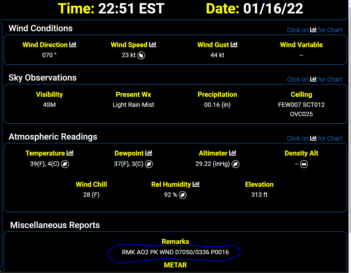
IAD gusted to 50 kts (58mph)

-
Umm... IAD just gusted up to 56mph out of the ENE!
-
Mid-Atlantic forum winter 2021/22 snow totals thread
George BM replied to North Balti Zen's topic in Mid Atlantic
Herndon, VA 11/30/2021: T 1/03/2022: 6.0" 1/07/2022: 4.8" 1/16-17/2022: 2.8" ... Total as of January 17, 2022: 13.6" Highest La Nina snow total IMBY since 2006. -
Just a little more than 1 1/2 hours after it was 23F IAD has officially hit the freezing mark. IAD: 32/29 as of 7:36pm. Strong WAA doing its thing.
-
Wonder how much accretion we get on the trees before we pull far enough above that freezing mark for accretion to stop? Probably enough to make the trees look pretty.
-
2.8" for the total here in Herndon before the flip. IAD was at 23F at 6:00pm. ... Now IAD has rocketed up to 30F as of 7:04pm est.
-
Nope. That's always been there. It's from some big hills to the SW of the site IIRC.