George BM
-
Posts
3,048 -
Joined
-
Last visited
Content Type
Profiles
Blogs
Forums
American Weather
Media Demo
Store
Gallery
Everything posted by George BM
-
This is a nice site for one-min obs at IAD. http://iadasos.org/IAD/index.html
-
Now IAD is at 85/58.
-
IAD has hit 83F so far today.
-
@SnowenOutThere Yeap. I know what you're about to post.

-
Oh wow. Both of you chasing. That's a nice duo between you and your wife.
-
Mid-Atlantic forum winter 2021/22 snow totals thread
George BM replied to North Balti Zen's topic in Mid Atlantic
Herndon, VA 11/30/2021: T 1/03/2022: 6.0" 1/07/2022: 4.8" 1/16-17/2022: 2.8" 1/20/2022: T 1/28/2022: 0.8" 2/13/2022: 1.4" 3/12/2022: 2.5" 3/26/2022: T 3/27/2022: T 3/28/2022: T 3/30/2022: T 4/09/2022: T ... Total as of April 10, 2022: 18.3" -
Or some severe and upper 70s?...
-
Got my April trace! Just had a light shower w/ big raindrops mixed in with graupel at 52F.
-
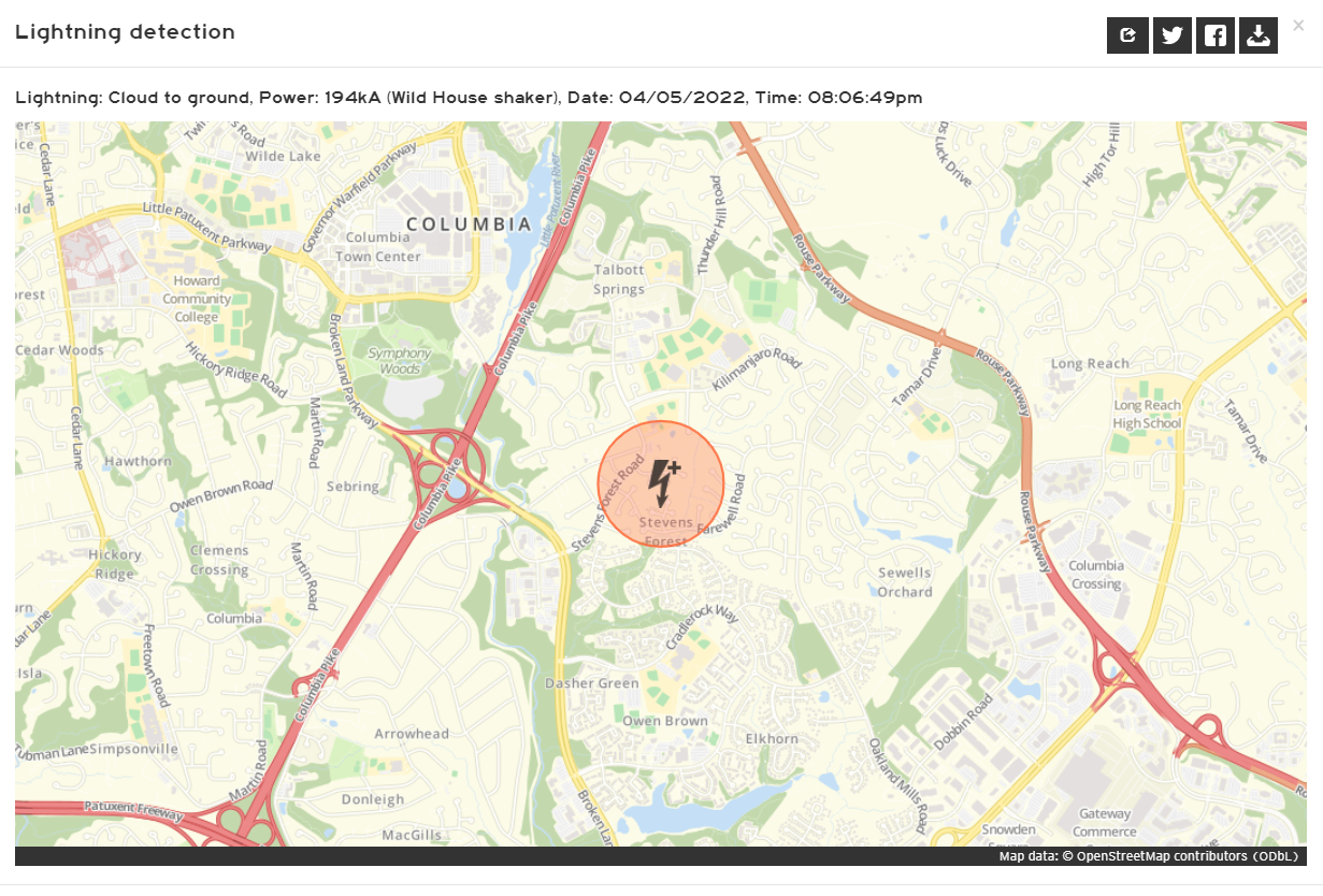
The bolt was a powerful 194kA positive CG. Lots of jumps, yelps and/or more personal "events" were probably had by peeps in the strike region... especially with no previous bolt to signify lightning in the area.

-
2022 Mid-Atlantic Severe Wx Thread (General Discussion Etc)
George BM replied to Kmlwx's topic in Mid Atlantic
-
Let the April traces commence!
-
Moving deeper into spring. Happy Pollen Sufferers Awareness Month!
-
New month starting. Baseball. NHL Playoffs w/ the Capitals? Booze consumption. Legit severe?
-
2022 Mid-Atlantic Severe Wx Thread (General Discussion Etc)
George BM replied to Kmlwx's topic in Mid Atlantic
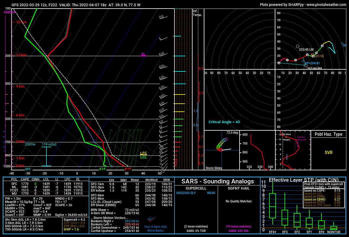
Some digital severe to enjoy from the 12z GFS today over Sterling, VA. Long range caveats (of course). But if nothing else it shows that we're reaching that TOY where our threats start becoming "CAPE-ier."
-
22... but I'm 25.
-
2022 Mid-Atlantic Severe Wx Thread (General Discussion Etc)
George BM replied to Kmlwx's topic in Mid Atlantic
June 13, 2013. A strong morning MCS stabilized the atmosphere a bit and we were downgraded to a SLGT by the 1630z update. Parts of the region particularly from northern/central Loudoun county eastwards into Montgomery and Howard counties and perhaps beyond got decent storms that afternoon w/ 40-50 kt effective bulk shear and up to 1,000J/kg MLCAPE. -
No you don't.
-
2022 Mid-Atlantic Severe Wx Thread (General Discussion Etc)
George BM replied to Kmlwx's topic in Mid Atlantic
A lot of the lightning bolts from the I-95 storms last night were strong w/ peak currents between 50-100 kiloamps (some were over 100kA). Generally the vast majority of bolts produce peak currents of roughly 20-30kA give or take. -
With cold temperature profiles and steep surface to 600mb lapse rates some of the most intense showers on Saturday could contain some graupel despite surface temps reaching 50+F. A rogue lightning discharge or two may even occur should any convection get deep enough.
-
I saw a flash of lightning in the 11pm hour last night. I, however, did not hear thunder. The storms went to my east. Herndon, VA.
-
2022 Mid-Atlantic Severe Wx Thread (General Discussion Etc)
George BM replied to Kmlwx's topic in Mid Atlantic
I'm thinking maybe some of us may hear thunder later this evening w/ some small elevated CAPE. The surface looks too stable for anything severe-wise up in these parts though areas, mainly south of Fredericksburg, could see some enhanced wind gusts and/or a low-level meso w/ convection rooted closer to the surface there. -
2022 Mid-Atlantic Severe Wx Thread (General Discussion Etc)
George BM replied to Kmlwx's topic in Mid Atlantic
There actually is a non-zero chance of some convection on Saturday. Models such as the NAM show at least a couple hundred J/kg of CAPE w/ decent shear. Perhaps a few lightning strikes and/or enhanced wind gusts? (General/MRGL type activity) -
Mid-Atlantic forum winter 2021/22 snow totals thread
George BM replied to North Balti Zen's topic in Mid Atlantic
Herndon, VA 11/30/2021: T 1/03/2022: 6.0" 1/07/2022: 4.8" 1/16-17/2022: 2.8" 1/20/2022: T 1/28/2022: 0.8" 2/13/2022: 1.4" 3/12/2022: 2.5" ... Total as of March 13, 2022: 18.3" -