

George BM
-
Posts
3,048 -
Joined
-
Last visited
Content Type
Profiles
Blogs
Forums
American Weather
Media Demo
Store
Gallery
Everything posted by George BM
-
2022 Mid-Atlantic Severe Wx Thread (General Discussion Etc)
George BM replied to Kmlwx's topic in Mid Atlantic
Seeing some 80-86mph winds on velocity scans with this one. -
2022 Mid-Atlantic Severe Wx Thread (General Discussion Etc)
George BM replied to Kmlwx's topic in Mid Atlantic
That's an error. -
2022 Mid-Atlantic Severe Wx Thread (General Discussion Etc)
George BM replied to Kmlwx's topic in Mid Atlantic
87/67 at IAD currently. -
2022 Mid-Atlantic Severe Wx Thread (General Discussion Etc)
George BM replied to Kmlwx's topic in Mid Atlantic
I could use an MCS. -
48F for the low at IAD tying the daily record set in 2000.
-
Happy Fathers Day and Happy Juneteenth to all!
-
I'm loving all of the old vintage planes taking off from Dulles International airport using Runway 01R. I've seen a couple DC3s and a fighter jet (probably an F-15,16 or 18) as well.
-
96/66 at IAD 2:15pm.
-
95/68 at IAD 12:59pm.
-
93/73 at IAD currently.
-
2022 Mid-Atlantic Severe Wx Thread (General Discussion Etc)
George BM replied to Kmlwx's topic in Mid Atlantic
Just noticed that from radarscope wondering whether it was a glitch. So you heard thunder from them? -
ROS. Ring of Smoke pattern. (Smoke aloft being carried around the ridge) A 'dull red circle' sunset inbound.
-
2022 Mid-Atlantic Severe Wx Thread (General Discussion Etc)
George BM replied to Kmlwx's topic in Mid Atlantic
My two amateur cents about this 'event': To @high risks point the HRRR was doing a very bad job with the handling and even initialization of the Chicago-Ohio MCS. @Kmlwx with great similar points about it. By mid-evening it was apparent that the HRRR was significantly underdoing the Chicago-Ohio MCS which would, obviously, in turn result in a less organized MCS following it from northern MI (the one the HRRR kept keying on to hit our region). Something else that I'll like to point out that I noticed were the storms that formed early in the afternoon yesterday in Indiana. No, not the one that brought a 98mph wind gust to Fort Wayne, IN, but the storms that grew upscale into an MCS that moved ESE through WV and into the central Appalachians by midnight (same activity that got @wxdude64 some late evening action). What that MCS created was a region of limited/no instability, especially in WV. In the time-sensitive loop below you can see how the MCS that hit Chicago and Fort Wayne splits into two separate convective line segments as it hits this 'used up' atmosphere with the SW segment going SSE through western WV and into far southwestern VA and the NE segment moving east into northern/central MD and southern PA. https://weather.cod.edu/satrad/?parms=regional-eastcoast-comp_radar-200-1-25-1&checked=map&colorbar=undefined The Cincinnati to WV MCS also left an MCV which may have tugged the OH MCV a little further south further limiting the impressive NW mid-level winds over us and shifting it southwest although I admittedly know far to little about this to say this is occurred for sure. In my opinion these things are what left most of VA without any real convection this morning. Of course, there are probably other more subtle features that affected things but those are the main ones I caught with my limited knowledge compared to actual meteorologists. -
2022 Mid-Atlantic Severe Wx Thread (General Discussion Etc)
George BM replied to Kmlwx's topic in Mid Atlantic
Completely unrelated to any thoughts about tonight/tomorrow... today marks nine years since the last time the immediate area was under a MOD risk of severe weather from the SPC. -
2022 Mid-Atlantic Severe Wx Thread (General Discussion Etc)
George BM replied to Kmlwx's topic in Mid Atlantic
Yeap. I remember the June 3, 2020 derecho to our north producing hurricane-force wind gusts despite only weak to modest CAPE available and early time of day owing to the MCSs cold pool/ rear-inflow jet. Granted there were a couple hours of solar heating before the storms got to New Jersey where the most extreme damage occurred. But it was still solidly before peak heating with relatively modest LLLRs. Not that I expect that here, of course. Just pointing that out. -
2022 Mid-Atlantic Severe Wx Thread (General Discussion Etc)
George BM replied to Kmlwx's topic in Mid Atlantic
Day 2 SLGT 2/15/15 Exerpt for MidAtl... ... At this time, one area of potentially greater storm coverage -- and thus severe potential, given the favorably strong wind field forecast atop the region -- will be along and east of the higher terrain of the central Appalachians. Storms should develop by early afternoon, and spread east-southeastward with time. Organized/rotating updrafts should evolve, given the available shear, with these stronger storms capable of producing large hail and damaging winds. Risk may continue well into the evening across portions of the area, as one of the more pronounced disturbances aloft shifts southeastward out of the Midwest and across the mountains during the evening/overnight. -
2022 Mid-Atlantic Severe Wx Thread (General Discussion Etc)
George BM replied to Kmlwx's topic in Mid Atlantic
Just for laughs. Lol NAM. Sounding from the 6z NAM for Warrenton at 2pm Tuesday. Just a small hunch but I feel like the NAM may be overdoing CAPE here just a little bit.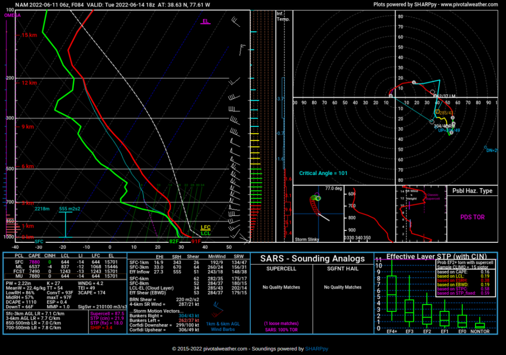
-
2022 Mid-Atlantic Severe Wx Thread (General Discussion Etc)
George BM replied to Kmlwx's topic in Mid Atlantic
Yeah. Some CAMs such as the 18z HRRR is starting to hint at moderate instability and deep-layer shear in place by Sunday afternoon. Would be nice to get some action in these parts on Sunday before our early/mid week derechos. -
2022 Mid-Atlantic Severe Wx Thread (General Discussion Etc)
George BM replied to Kmlwx's topic in Mid Atlantic
Sunday has actually had one of my eyes for the past 36-48 hours. Not for anything too major but some models have been showing fairly decent deep-layer shear for the day. It's just the CAPE that looks rather modest for anything too significant att. -
The storms outran the cold front to an extent. The wind shift and following lower dewpts seem to be located near I-81 atm.
-
2022 Mid-Atlantic Severe Wx Thread (General Discussion Etc)
George BM replied to Kmlwx's topic in Mid Atlantic
I really hope we get a pattern similar to what's being advertised by the GFS. Obvious uber-long range caveat aside, that would easily be a MOD risk worthy day from the MidAtl up into the Northeast verbatim. -
2022 Mid-Atlantic Severe Wx Thread (General Discussion Etc)
George BM replied to Kmlwx's topic in Mid Atlantic
Central US ridges and NW flow over the Mid-Atlantic in June = a happy weenie A happy SEVERE weenie people! Calm down. -
2022 Mid-Atlantic Severe Wx Thread (General Discussion Etc)
George BM replied to Kmlwx's topic in Mid Atlantic
BTW, with that watch the probs were: TOR: 20/5 WIND: 80/40 HAIL: 70/30 And just in case you're curious the first 20080604 watch had the same wind and hail probs but with 40/20 tornado probs. -
2022 Mid-Atlantic Severe Wx Thread (General Discussion Etc)
George BM replied to Kmlwx's topic in Mid Atlantic
This is actually the site that wasn't working for me. But now it finally started loading. But still, thank you. -
2022 Mid-Atlantic Severe Wx Thread (General Discussion Etc)
George BM replied to Kmlwx's topic in Mid Atlantic
Where did you retrieve this?... As I cannot seem to retrieve it from SPCs Severe Watches archive ATM.


