sbnwx85
-
Posts
1,778 -
Joined
-
Last visited
Content Type
Profiles
Blogs
Forums
American Weather
Media Demo
Store
Gallery
Everything posted by sbnwx85
-

Winter 2025-26 Medium/Long Range Discussion
sbnwx85 replied to michsnowfreak's topic in Lakes/Ohio Valley
18z GFS would make the Bears/Packers game very entertaining. -
Amazing to see how long those Texas and California droughts last.
-
I guess I can’t complain yet.
-
I was in Elkhart, but I don’t remember that footage. I work at WSBT now, so I’ll have to see if I can find that archived somewhere! Great memories, indeed. I need another big dog like this in my adulthood to remember it clearer.
-
If you could re-experience ONE winter event....
sbnwx85 replied to cyclone77's topic in Lakes/Ohio Valley
Some good articles on this one! Here’s one from Skilling: https://wgntv.com/weather/weather-blog/chicagos-heart-attack-snowstorm-of-dec-15-1987/amp/ -
If you could re-experience ONE winter event....
sbnwx85 replied to cyclone77's topic in Lakes/Ohio Valley
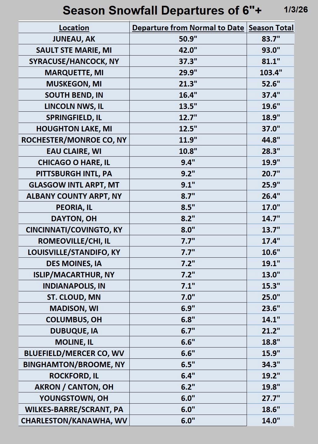
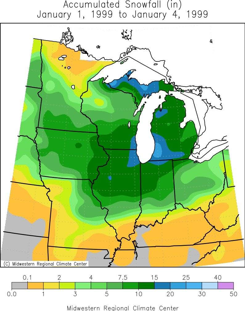
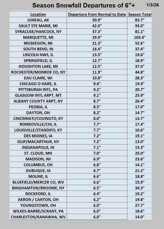
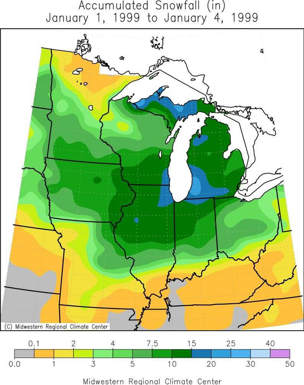
I posted in the banter thread since today is the anniversary: The Monster Snow Storm of ‘99. It was relatively well-forecast, although the full extent of the storm wasn’t known until a couple days before. My grandpa passed away a few days after Christmas, and I can distinctly remember my uncle saying two days before the storm hit “God asked John what he wanted to leave behind for his family, and he said a big ass snowstorm!” It was a Saturday when the snow began and the tv chief meteorologists were working, cutting in occasionally with updates. That was highly unusual. At home, there was a plastic pipe that stuck out of the ground in the neighbor’s yard about a foot up. I remember watching the snow slowly climb up and around it until it was covered… and then some. When it was all said and done we had 18” on the ground. Still a personal record. Sadly, I didn’t get to enjoy it as I got a horrible stomach flu that night. By Tuesday, I was finally feeling better and was astonished by how brightly the sun shined off the giant blanket of snow. There were a number off roof and structural collapses, including the patio roof at my grandma and grandpa’s house. Schools finally reopened on Wednesday but closed again Thursday after an advisory-level snow Wednesday night. Usually, we wouldn’t bat an eye at 4” of snow, but with 18” on the ground, it overwhelmed clean up crews. I was 13 and remember the snow piles in my own front yard taller than a me. It was wild seeing walls of snow on either side of me while walking through the neighborhood. Nothing has come close to that event. There was a one-two punch from a system and lake-effect that dropped 14” on NYD ‘08. And several events that have dropped double digits, but nothing like ‘99. (I should mention, GHD I dryslotted us, and I was living in Central IL for GHD II). The only other storm that has had as much of an impact was the ice storm in January of 2002. That was a more localized event. Half inch of ice with 2-3” of heavy snow on top plus high winds devastated the electric grid. Countless tree limbs down and no power for four days. It took several days before temps rose above freezing. Very memorable but not sure I’d like to re-live it. -
Happy anniversary to the greatest snowstorm of my life! Watching the snow pile up that day was something I’ll never forget.
-
Picked up an inch before switching to freezing drizzle. 28 degrees so it’s creating a glaze pretty efficiently on the roads.
-
Winter 2025-26 Medium/Long Range Discussion
sbnwx85 replied to michsnowfreak's topic in Lakes/Ohio Valley
GFS showing a more active pattern late next week. Something to watch. -
Just under an inch here.
-
Winter 2025-26 Short Range Discussion
sbnwx85 replied to SchaumburgStormer's topic in Lakes/Ohio Valley
3-6" over two days, but it'll be so fluffy it'll compact to 2" real quick. -
That's why I prefer gummies.
-
Light snow kept falling and overnight. Picked up another inch. Up to about 4.5”. Forecast calls for another 2-5” on NYE. December is going to look halfway decent when all said and done. I’ve measured 12.6” imby now for the month.
-
I figured I’d be nice and shovel the neighbor’s sidewalk tonight since she sometimes snowblows mine. I only had an inch or two across my sidewalk… so no big deal, right? It turns out all my snow collected on her sidewalk — about 8” deep. That’s what I get for being nice.
-
About 5" on the ground at work. I'm going to bet there's 3-4" at home, further away from the lake.
-
Ripping now. Dendrites are surprisingly good here too. Stacking nicely.
-
We already have an inch down IMBY. I opened the door to let the dogs out back and the cold, snow and wind is like slap in the mouth… especially compared to 64 degrees yesterday. Forecast was upped to 3-7” overnight. Wouldn’t be surprised if we get upgraded to a warning if the lake effect continues today.
-
Felt

-
An all-timer right here.
-
Blizzard to the north of me, tornadoes to the south, here I am, stuck in the middle with you
-
Def seems like blizzard conditions will occur along the Lake Michigan shoreline in Western Michigan on Monday. Locally, the highest winds may not quite coincide with the best snows. Probably end up with an advisory IMBY.
-
Winter 2025-26 Medium/Long Range Discussion
sbnwx85 replied to michsnowfreak's topic in Lakes/Ohio Valley
Just read the GRR forecast disco and it has my attention. Hoping we can get that lake effect into Indiana to have some major impacts locally. As for the snow, synoptic scale rain will switch to lake effect snow Sunday night into Monday. Lake effect snow will continue from Monday into Tuesday with accumulations expected. The snow will be spread across all of Lower Michigan given the strength of the wind. As colder air pours in on Monday and the snow becomes drier and more powdery visibility concerns will develop. Winter headlines will obviously be forth coming with later shifts as Monday approaches. All headlines will be on the table given the strength of the wind, which when combined with accumulating lake effect snow will make for major travel concerns. -
Winter 2025-26 Medium/Long Range Discussion
sbnwx85 replied to michsnowfreak's topic in Lakes/Ohio Valley
Although most of us won’t see much snow from this (although the UP is going to get hammered), Skilling points out Sunday’s system will undergo bombogensis. So… that’s something? -
Winter 2025-26 Medium/Long Range Discussion
sbnwx85 replied to michsnowfreak's topic in Lakes/Ohio Valley
Wind and lake effect have some potential to make things interesting locally on Monday. Not huge amounts, but wind-driven snow and cold. Beyond that, the Euro at least has a couple fantasy storms. -
Winter 2025-26 Medium/Long Range Discussion
sbnwx85 replied to michsnowfreak's topic in Lakes/Ohio Valley
Looks like a swing and a miss unless you only look at the Canadian. 12z runs were brutal overall.