sbnwx85
-
Posts
1,928 -
Joined
-
Last visited
Content Type
Profiles
Blogs
Forums
American Weather
Media Demo
Store
Gallery
Everything posted by sbnwx85
-
This is our last hope to pull something out of this weekend's system. #ThanksTrump
-

1/24-1/25 Major Winter Storm - S. IL, IN, and OH
sbnwx85 replied to A-L-E-K's topic in Lakes/Ohio Valley
3” final call. -
1/24-1/25 Major Winter Storm - S. IL, IN, and OH
sbnwx85 replied to A-L-E-K's topic in Lakes/Ohio Valley
Another nudge north. Although you can tell the precip shield struggles to get any further north. -
1/24-1/25 Major Winter Storm - S. IL, IN, and OH
sbnwx85 replied to A-L-E-K's topic in Lakes/Ohio Valley
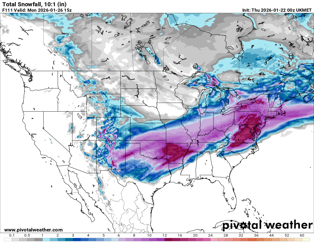
UKIE looks about the same as previous runs on the 10:1 maps although there is now a much cleaner cut on the northern edge of the 6” snows.
-
1/24-1/25 Major Winter Storm - S. IL, IN, and OH
sbnwx85 replied to A-L-E-K's topic in Lakes/Ohio Valley
-
1/24-1/25 Major Winter Storm - S. IL, IN, and OH
sbnwx85 replied to A-L-E-K's topic in Lakes/Ohio Valley
2. That model has been terrible this season. -
1/24-1/25 Major Winter Storm - S. IL, IN, and OH
sbnwx85 replied to A-L-E-K's topic in Lakes/Ohio Valley
Early, early call if the foreign models are correct: 4-6" in Chicagoland; 6-8" across Michiana. Add an inch or two for lake-enhancement if it applies to your backyard. Obviously, the bigger the totals, the more south and east you get. -
1/24-1/25 Major Winter Storm - S. IL, IN, and OH
sbnwx85 replied to A-L-E-K's topic in Lakes/Ohio Valley
6. 6z and 18z data are off runs. -
1/24-1/25 Major Winter Storm - S. IL, IN, and OH
sbnwx85 replied to A-L-E-K's topic in Lakes/Ohio Valley
European just now starting its 12z run. A little delayed. -
1/24-1/25 Major Winter Storm - S. IL, IN, and OH
sbnwx85 replied to A-L-E-K's topic in Lakes/Ohio Valley
-
Winter 2025-26 Short Range Discussion
sbnwx85 replied to SchaumburgStormer's topic in Lakes/Ohio Valley
DAB here with maybe another half hour of snow to fall. -
1/24-1/25 Major Winter Storm - S. IL, IN, and OH
sbnwx85 replied to A-L-E-K's topic in Lakes/Ohio Valley
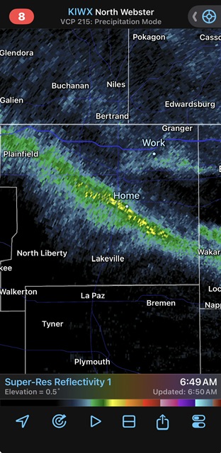
6z Euro bumped north but the precip shield wasn’t as expansive on the northwest side, so Southern Wisconsin doesn’t get in on the action like the 00z run. Keep in mind this also includes dusters and lake effect.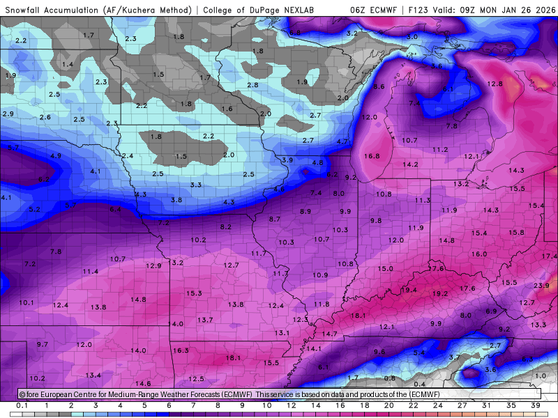
-
Winter 2025-26 Medium/Long Range Discussion
sbnwx85 replied to michsnowfreak's topic in Lakes/Ohio Valley
Oh lawdy she comin… -
Winter 2025-26 Medium/Long Range Discussion
sbnwx85 replied to michsnowfreak's topic in Lakes/Ohio Valley
Euro another nudge north early on… I miss these days of play by play as the models roll in. -
Winter 2025-26 Medium/Long Range Discussion
sbnwx85 replied to michsnowfreak's topic in Lakes/Ohio Valley
Excitement building. It’s palpable -
Winter 2025-26 Medium/Long Range Discussion
sbnwx85 replied to michsnowfreak's topic in Lakes/Ohio Valley
Actually NYC still does pretty well here so whatever lol -
Winter 2025-26 Medium/Long Range Discussion
sbnwx85 replied to michsnowfreak's topic in Lakes/Ohio Valley
East coast forum would be in shambles. Rooting for this. -
Winter 2025-26 Medium/Long Range Discussion
sbnwx85 replied to michsnowfreak's topic in Lakes/Ohio Valley
Went to visit the Southeast forum. First post I saw said “Stop. Final warning.” So they seem to be handling things well… -
Sage advice
-
No bugs at least
-
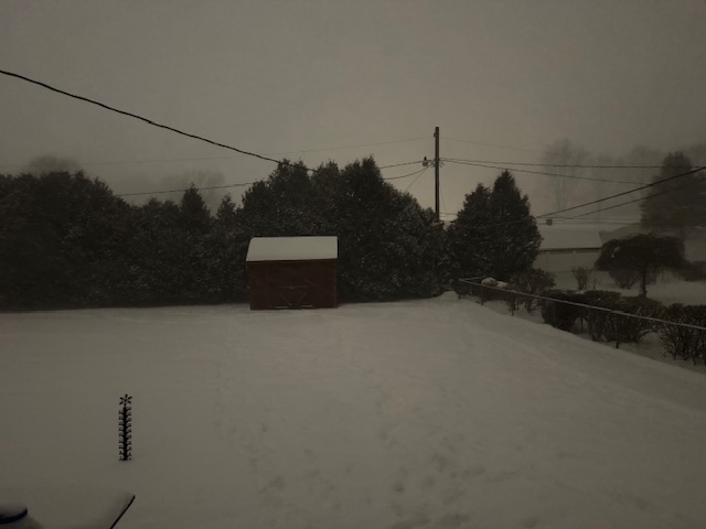
Frigid, windy day with some blowing snow in my neighborhood. The lake effect pixies plus blowing snow are making for tough conditions when you get into the northern part of St Joseph County. There’s a pile up on the Toll Road right now. I can’t even imagine how bad it must be along the west coast of Michigan today.
-
Winter 2025-26 Short Range Discussion
sbnwx85 replied to SchaumburgStormer's topic in Lakes/Ohio Valley
Taking my 2.5” from overnight with a smile. (That’s what she said?) -
Blizzard-like under this narrow snow squall.
-
Winter 2025-26 Short Range Discussion
sbnwx85 replied to SchaumburgStormer's topic in Lakes/Ohio Valley
Nothing to see here. Go about your business. The WWA for me is really for the northern third of the county. I’ll end up with two inches of wind swept snow over the course of 24 hours. -
Winter 2025-26 Medium/Long Range Discussion
sbnwx85 replied to michsnowfreak's topic in Lakes/Ohio Valley
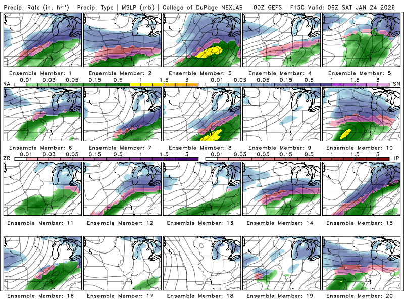
GFS operational was much wimpier with next weekend’s storm but there are several good hits on the ensembles