

sbnwx85
-
Posts
1,927 -
Joined
-
Last visited
Content Type
Profiles
Blogs
Forums
American Weather
Media Demo
Store
Gallery
Everything posted by sbnwx85
-

Winter 2025-26 Medium/Long Range Discussion
sbnwx85 replied to michsnowfreak's topic in Lakes/Ohio Valley
55 Friday, 40 Saturday, 32 Sunday, with a snowstorm in Central IL/IN/OH. Tough miss. Bring on Spring and the mud. -
Winter 2025-26 Short Range Discussion
sbnwx85 replied to SchaumburgStormer's topic in Lakes/Ohio Valley
South Bend picked up 9.2" from Sunday/Monday's lake effect snow event. That brings the seasonal total to 91.1". It is the 11th snowiest winter in South Bend history. Monthly Total Snowfall for South Bend Area, IN (ThreadEx) Click column heading to sort ascending, click again to sort descending. 1977-1978 0.0 0.0 0.0 0.3 30.3 33.6 86.1 16.6 5.1 T 0.0 0.0 172.0 1981-1982 0.0 0.0 0.0 0.1 9.1 41.3 41.3 19.2 10.2 14.0 0.0 0.0 135.2 1976-1977 0.0 0.0 0.0 0.8 21.6 37.6 37.2 13.9 15.8 2.3 0.0 0.0 129.2 1966-1967 0.0 0.0 T T 16.2 18.2 30.4 31.6 11.3 2.9 0.0 0.0 110.6 2013-2014 0.0 0.0 0.0 0.3 11.2 18.5 46.6 19.7 11.8 1.1 0.0 0.0 109.2 2010-2011 0.0 0.0 0.0 0.0 1.3 23.6 53.8 25.5 1.4 T 0.0 0.0 105.6 1962-1963 0.0 0.0 0.0 8.6 3.0 41.9 16.4 21.7 10.4 0.5 0.0 0.0 102.5 1978-1979 0.0 0.0 0.0 0.0 7.5 26.4 45.1 15.9 6.3 0.1 0.0 0.0 101.3 1959-1960 0.0 0.0 0.0 0.0 11.1 8.7 12.4 28.3 33.9 0.7 T 0.0 95.1 2017-2018 0.0 0.0 0.0 T T 32.4 22.0 29.6 7.6 1.5 0.0 0.0 93.1 2025-2026 0.0 0.0 0.0 0.0 27.1 10.0 38.6 15.4 M M M M 91.1 At home, I picked up 4.8", bringing my season total to 75.6" This ties my personal record for the snowiest winter of my life. Congrats to me. -
Winter 2025-26 Medium/Long Range Discussion
sbnwx85 replied to michsnowfreak's topic in Lakes/Ohio Valley
Seems on fair that winter would be bookended by two big snowstorms with CAD in between. (Save the LE areas obviously) -
Winter 2025-26 Medium/Long Range Discussion
sbnwx85 replied to michsnowfreak's topic in Lakes/Ohio Valley
@Chicago Stormstarted the post-Thanksgiving thread, and it was a success. I think only he should start the one for the potential Sunday-Monday storm. -
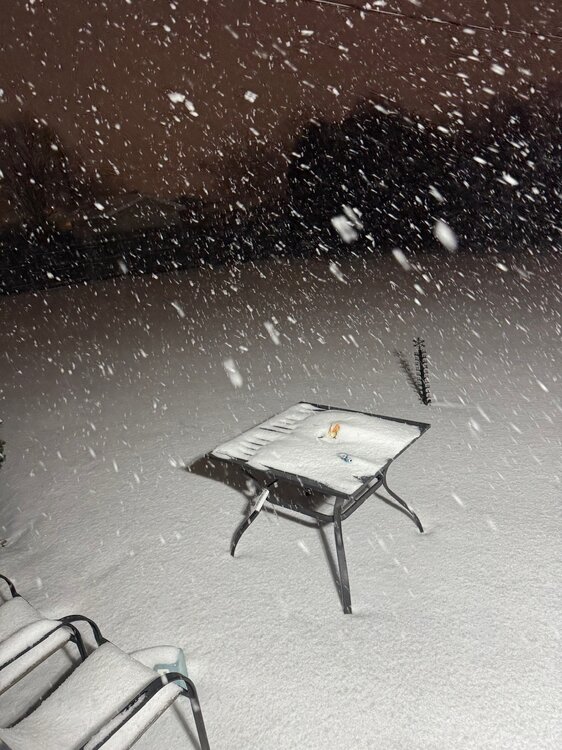
Sun is out now. 4.8” on the ground.
-
A reminder of what rippage looks like for y’all.
-
Tough look for my previous comments.
-
Just got home from a weekend out of town. Approaching 3” of lake effect in the backyard. The advance Travelers Advisory (might as well get used to it) meant the roads were pretreated and made for an easy drive from the Chicago burbs. It’s those 1-2” snows that are the worst.
-
Euro stinks. GFS is king.
-
GFS on an island last I checked but definitely the one I’m pulling for.
-
Winter 2025-26 Short Range Discussion
sbnwx85 replied to SchaumburgStormer's topic in Lakes/Ohio Valley
Advisory level lake event Sunday-Monday here. Final call: 3” -
Winter 2025-26 Medium/Long Range Discussion
sbnwx85 replied to michsnowfreak's topic in Lakes/Ohio Valley
Whoa, optimistic! -
Winter 2025-26 Medium/Long Range Discussion
sbnwx85 replied to michsnowfreak's topic in Lakes/Ohio Valley
To your point, lots of moving parts. Pretty active pattern, and as you've been saying, potential is there. Just need things to line up. -
Winter 2025-26 Medium/Long Range Discussion
sbnwx85 replied to michsnowfreak's topic in Lakes/Ohio Valley
12z GFS says hold up, wait a minute.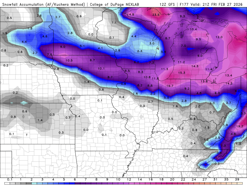
-
Low, long rumbles.
-
Getting some good rumbles.
-
I saw a ladybug in the backyard today. Just amazing, some of the insects are reappearing already. They're in for a rude awakening next week.
-
Winter 2025-26 Medium/Long Range Discussion
sbnwx85 replied to michsnowfreak's topic in Lakes/Ohio Valley
Nice to melt the ice so we can get the full lake-effect back. Sunday night into Monday looks interesting locally. -
Heard a rumble of thunder early this morning. Now, as the great Sophie B. Hawkins once said “It feels like spring time on this February morning.”
-
What I love about February is toggling between SPC and Kuchera maps on a daily basis. ...THERE IS A SLIGHT RISK OF SEVERE THUNDERSTORMS FOR PARTS OF THE LOWER/MIDDLE OHIO VALLEY... ...SUMMARY... Severe thunderstorms with potential to produce a few tornadoes and damaging wind gusts are possible across parts of the middle Mississippi into lower Ohio Valleys Thursday afternoon into early evening. ...Synopsis... Two shortwave troughs are expected to quickly lift north-northeastward through the central Plains and into the Ohio Valley region on Thursday. The initial perturbation will reach Illinois/Indiana by early afternoon. The intensity of this feature will remain modest with perhaps some gradual weakening in time. The second trough will evolve in the lower Missouri Valley during the evening and intensify as it approaches the lower Ohio Valley by Friday morning. At the surface, a cyclone will deepen as it lifts northeastward from eastern Kansas into the Great Lakes region. At least partially modified Gulf moisture will advect northward ahead of the surface cold front from the Upper Midwest into the southern Plains. ...Lower/middle Ohio Valley... Ahead of the cold front, a prefrontal trough/pseudo dryline is expected to be the focus for convective development during the afternoon. The degree/quality of moisture return ahead of this feature will be key in terms of the overall magnitude of the severe threat. Current observations (Tuesday) from soundings depict a very modest moist layer along the Gulf coast. A modest shortwave trough on Tuesday night into Wednesday will lift northward too quickly for more substantial moisture return. The surface pattern on Thursday will be more robust, but deeper moisture may still not reach far enough north given that mid 60s F dewpoints are only as far north as the central Gulf currently. Guidance suggests mid to upper 50s F dewpoints are most probable, which does seem reasonable. That said, temperatures aloft will not be overly cold and lapse rates will not be overly steep. This will lead to convection that may remain somewhat low topped in nature. Despite limiting factors within the environment, 40-50 kts of effective shear roughly perpendicular to the boundary will favor discrete storms. Low-level flow will be increasing with time as well. Supercells capable of few tornadoes, damaging winds, and isolated large hail are possible during the afternoon/evening.
-
South Bend missed its daily record high of 60 by one degree on Monday. 59’d.
-
48 currently feels like 58. Rare to get this warmth with full sun this time of year. Drinking it up. Got a nice walk in this morning before work.
-
Winter 2025-26 Medium/Long Range Discussion
sbnwx85 replied to michsnowfreak's topic in Lakes/Ohio Valley
Def hoping for some boomers around here. May even get a marginal severe risk. -
Snowpack taking a big hit obviously. Still have 4” in the shade. Bare spots popping up in the sun. 43 feels phenomenal. 60 on Wednesday is gonna have me breaking out the shorts.
-
38 and sun this morning feels more like 60. I had my first “We have Tornado Warnings” dream of the year. I think my body is ready for Spring.


