sbnwx85
-
Posts
1,428 -
Joined
-
Last visited
Content Type
Profiles
Blogs
Forums
American Weather
Media Demo
Store
Gallery
Everything posted by sbnwx85
-
We got a real loud storm at about 3 am. It dropped under a half inch of rain. We’ll see how much the remnants from Chicagoland bring.
-
I'm hoping to cash in on the scraps tomorrow morning. We need the rain badly.
-
We had a nice morning for some lawn work here. And I got all the bird poop off the mailbox. It's amazing how much they poop on that thing. Anyway, @HillsdaleMIWeathermight cash in on a rogue storm soon.
-
Under a Severe Watch but the line initiated overhead and is already to my east. Not expecting much.
-
Storms dropped 1.34” of rain over the last 24 hours.
-
Getting some solid boomers.
-

2025 Short Range Severe Weather Discussion
sbnwx85 replied to Chicago Storm's topic in Lakes/Ohio Valley
Decent potential from northern Iowa into southern Wisconsin today. -
Storms already popping up out here.
-
Yes, exactly. I made that post at 6:30 before I was fully awake and didn't articulate fully what I was trying to say. IWX also mentioned they went with a warning since it's the first heat wave of the year.
-
IWX kind of on an island issuing an Extreme Heat Warning but with the overnight lows being so incredibly warm, I think it’s the right call.
-
RECORD EVENT REPORT NATIONAL WEATHER SERVICE NORTHERN INDIANA 205 AM EDT MON JUN 23 2025 ...RECORD WARM MINIMUM TEMPERATURE SET AT SOUTH BEND FOR JUNE 22ND... A RECORD WARM MINIMUM TEMPERATURE OF 77 WAS SET AT SOUTH BEND YESTERDAY. THIS BREAKS THE OLD RECORD OF 74 SET IN 2024 AND 1988.
-
Warnings for 90 mph winds in North Dakota currently
-
105 mph is wild. URGENT - IMMEDIATE BROADCAST REQUESTED Tornado Watch Number 448 NWS Storm Prediction Center Norman OK 750 PM CDT Fri Jun 20 2025 The NWS Storm Prediction Center has issued a * Tornado Watch for portions of Northwest into West-Central Minnesota Central and Eastern North Dakota Northern South Dakota * Effective this Friday night and Saturday morning from 750 PM until 300 AM CDT. * Primary threats include... A couple tornadoes possible Widespread damaging winds expected with isolated significant gusts to 105 mph likely Scattered large hail and isolated very large hail events to 2 inches in diameter possible SUMMARY...An intense squall line is forecast to rapidly move east across the Watch area this evening into the overnight period. A potential supercell tornado risk may develop with any storms that develop ahead of the squall line. A tornado risk may accompany the stronger and more persistent embedded circulations within the line. Widespread severe gusts (60-80 mph) are expected. Swaths of 80-105 mph gusts are possible with the more intense portions of the convective line.
-
Overview of Wednesday's event across IWX: A line of strong to severe storms moved across the area in the afternoon and evening of Wednesday, June 18th, 2025. Overall, damage was generally confined to numerous instances of tree damage, scattered reports of power lines down, and some associated roof/siding damage to buildings/homes. Wind gusts were estimated to be between 50-60 mph. There were a few reports of quarter to golf ball size hail in northeast Indiana. The most extensive wind damage occurred in Van Wert County, OH; wind speeds of up to 70 mph downed an estimated 100 trees and caused minor damage to homes and buildings in the city of Van Wert. Van Wert County EMA director Rick McCoy said that this was the worst wind damage he had seen since the 2012 derecho. There were no injuries or fatalities. https://www.weather.gov/iwx/06182025_SevereWeather?fbclid=IwY2xjawLCqTRleHRuA2FlbQIxMABicmlkETBydHc3SEtscWREOFdOT1owAR7GZzaMMAguYLVWOFAczQU94f_75FcJfH_dNy9cL1It5yYarhFeMlsBMcNk1A_aem_ghpY_Dnre1a_h08Wrs5Clw
-
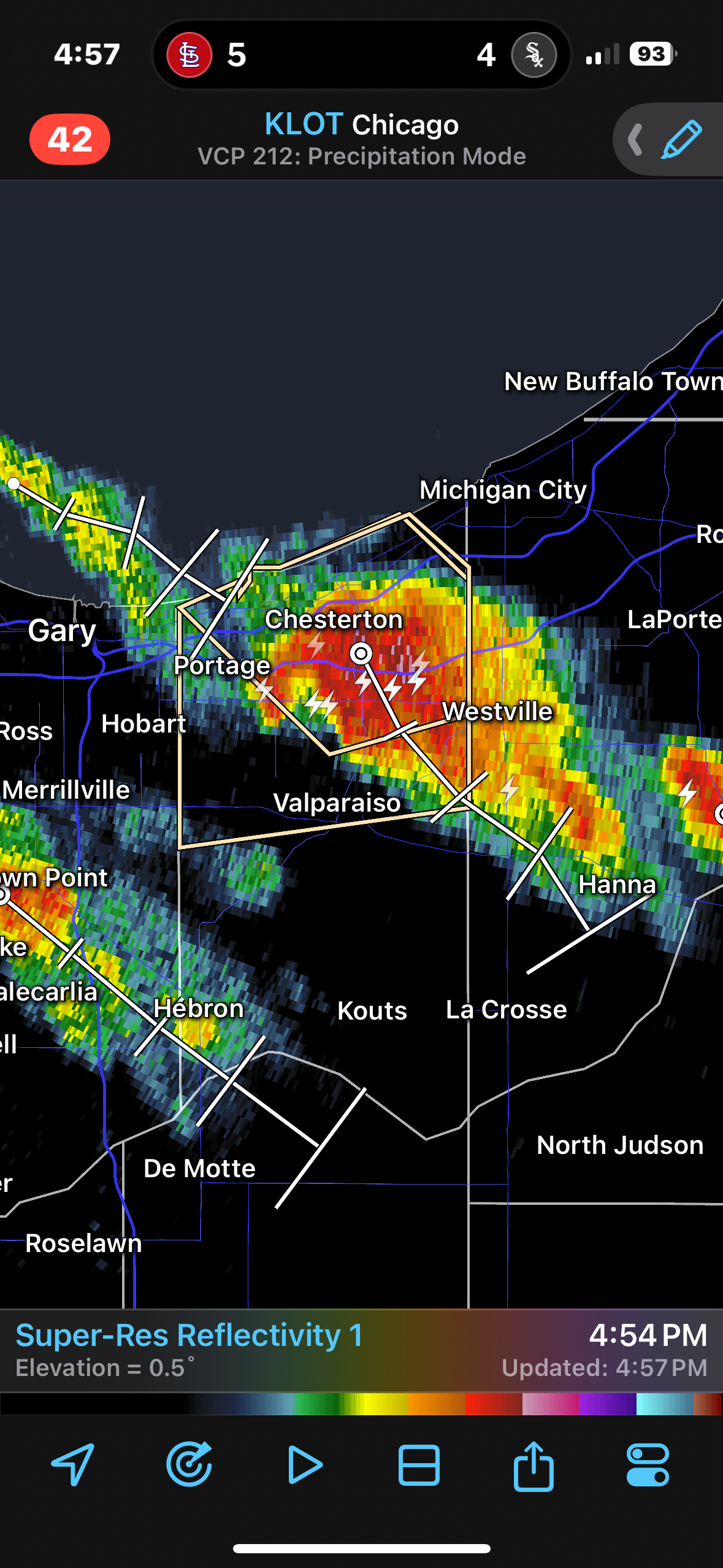
Gnarly looking storm over Porter County.

-
I still got a good front-end thump of 50-55 mph winds. It knocked the power out at work for a few seconds before the generator kicked in.
-
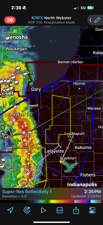
The line is weakening a bit up here. I think it’s outrunning the best dynamics.
-
It's hauling. ...A SEVERE THUNDERSTORM WARNING REMAINS IN EFFECT UNTIL 330 PM EDT/230 PM CDT/ FOR WHITE...PULASKI...NORTHWESTERN CASS...STARKE AND SOUTHERN LA PORTE COUNTIES... At 259 PM EDT/159 PM CDT/, severe thunderstorms were located along a line extending from Roselawn to near Wolcott to near Brookston, moving northeast at 75 mph. HAZARD...70 mph wind gusts and penny size hail. SOURCE...Radar indicated. IMPACT...Expect considerable tree damage. Damage is likely to mobile homes, roofs, and outbuildings.
-
One of the weirder warnings I’ve seen with a wide gap between the warning and actual line of storms. And it’s warned for 70 mph winds.
-
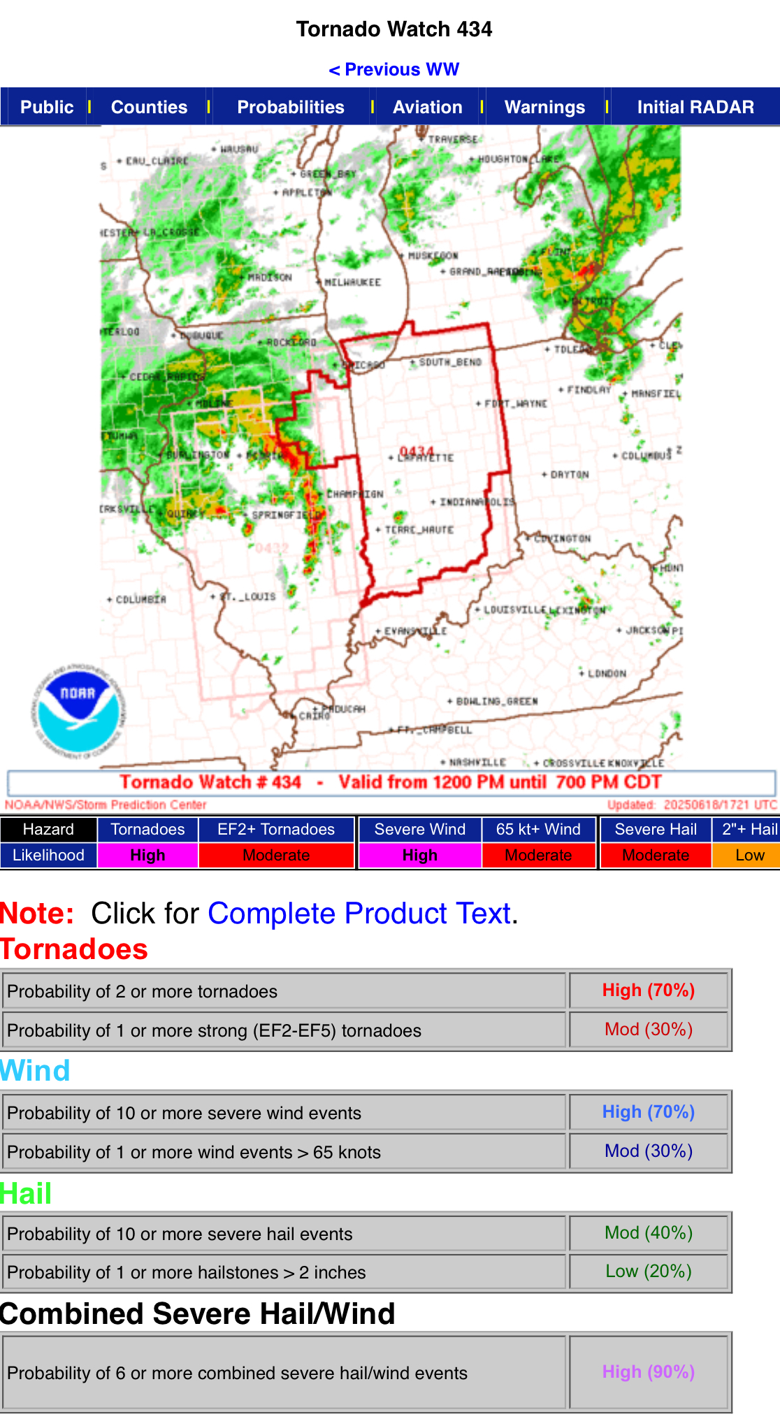
Let's goooo Mesoscale Discussion 1346 NWS Storm Prediction Center Norman OK 1244 PM CDT Wed Jun 18 2025 Areas affected...eastern IL and western/northern IN Concerning...Tornado Watch 432...434... Valid 181744Z - 181945Z The severe weather threat for Tornado Watch 432, 434 continues. SUMMARY...Tornado and damaging wind potential should increase into late afternoon amid multiple bands of thunderstorms spreading east-northeast from Illinois into Indiana. A strong tornado is possible. DISCUSSION...Primary midday tornado potential has been prominent near the immediate MCV/surface cyclone in west-central IL, including a damaging tornado in Morgan County, IL during the past hour. Enhanced surface vorticity within this persistent pocket of lower-topped storms should continue to pose a tornado threat across central IL. An expanding arc of broken to linear convection into east-central IL should have increasing tornado/damaging wind potential as it spreads into IN through late afternoon. Area VWPs have been a bit subdued on 0-1 km shear, but the PAH/VWX VWPs has gradually strengthened and this should spread north-northeast across the Wabash Valley. Tornado potential may be relatively maximized with 1) discrete, sustained supercells on the southern portion of the broader convective band and 2) in the more bent-back arc across northeast IL/northern IN with hybrid supercell/QLCS mesovortices.
-
Nice probs on the new Tornado Watch.
-
Correlation coefficient shows it’s on the ground. Looks like it may have clipped the west side of Jacksonville before going toward the airport.
-
Three tornado warnings before noon across Central Illinois. I think it might be one of those days.
-
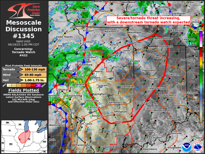
Mesoscale Discussion 1345 NWS Storm Prediction Center Norman OK 1057 AM CDT Wed Jun 18 2025 Areas affected...eastern IL...western/northern IN...far southwest Lower MI Concerning...Tornado Watch 432... Valid 181557Z - 181800Z The severe weather threat for Tornado Watch 432 continues. SUMMARY...Severe threat should increase substantially through mid-afternoon as an arc of storms intensifies to the east-northeast from central Illinois. A few tornadoes, scattered damaging winds, and isolated severe hail will remain possible. Downstream tornado watch issuance is anticipated to the northeast of Ww 432. DISCUSSION...While the primary surface cyclone and attendant MCV are centered near the northeast MO/west-central IL border area, a downstream arc of increasing deep convection is expected to strengthen across central IL. With mid 70s surface dew points common across southern IL/IN, a pronounced MLCAPE gradient is setting up from south to north. A compact belt of strong 700-500 mb southwesterlies in the LSX VWP, recently sampled by the ILX VWP as well, should support a broken band of supercells within this leading arc as it spreads northeast. The potential for tornadoes has increased and a 10 percent tornado probability will be added in the 1630Z D1 Outlook. The LSX VWP also indicates low-level SRH diminishing behind this leading arc, but some tornado threat should linger near the immediate MCV/surface low. ..Grams/Hart.. 06/18/2025 ...Please see www.spc.noaa.gov for graphic product... ATTN...WFO...IWX...GRR...IND...LOT...ILX...LSX...DVN...
-
Tornado Watch coming for much of Central and Southern Illinois.