

sbnwx85
-
Posts
1,927 -
Joined
-
Last visited
Content Type
Profiles
Blogs
Forums
American Weather
Media Demo
Store
Gallery
Everything posted by sbnwx85
-
Looks like more summer-like weather should return soon. So we got that going for us.
-
Decent. Constant lightning and thunder. No hail and winds gusting to about 40 mph. Nice wrinkle during an otherwise chilly pattern.
-
I was going to say this is a solid long-duration garden variety event. Then we got a Severe Thunderstorm Warning for a pretty decent looking cell just to my west. We’ll see how it holds up.
-
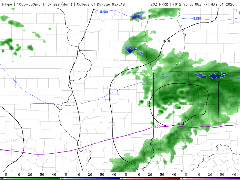
We got reports of snow mixing with rain in Ligonier, IN, this morning.
-
We'll add a little bit to this month's precipitation total tonight, but as of right now, South Bend has recorded 6.22" of rain in April. This makes it the 5th wettest April on record. If you combine March and April, South Bend saw 11.54" of precipitation, the 3rd most all-time for March and April combined.
-
Cold start. Might snow.
-
We might, albeit unlikely, mix in some snowflakes with the rain tonight. I’ll probably be asleep for it.
-
We're due to dry out. Shame it comes at the peak of tornado season. Still plenty of hope for derecho season. #teamderecho
-

Potential Sever Weather Outbreak 4/27/2026
sbnwx85 replied to pen_artist's topic in Lakes/Ohio Valley
Round 2 of thundery rain is almost here. -
Potential Sever Weather Outbreak 4/27/2026
sbnwx85 replied to pen_artist's topic in Lakes/Ohio Valley
70 mph gust reported in South Bend with the wake low moving through. -
Potential Sever Weather Outbreak 4/27/2026
sbnwx85 replied to pen_artist's topic in Lakes/Ohio Valley
HRRR at least makes things worth keeping an eye on for the rest of us tonight. -
Potential Sever Weather Outbreak 4/27/2026
sbnwx85 replied to pen_artist's topic in Lakes/Ohio Valley
The most exciting part of this event up here might be the wake low behind the rain this afternoon.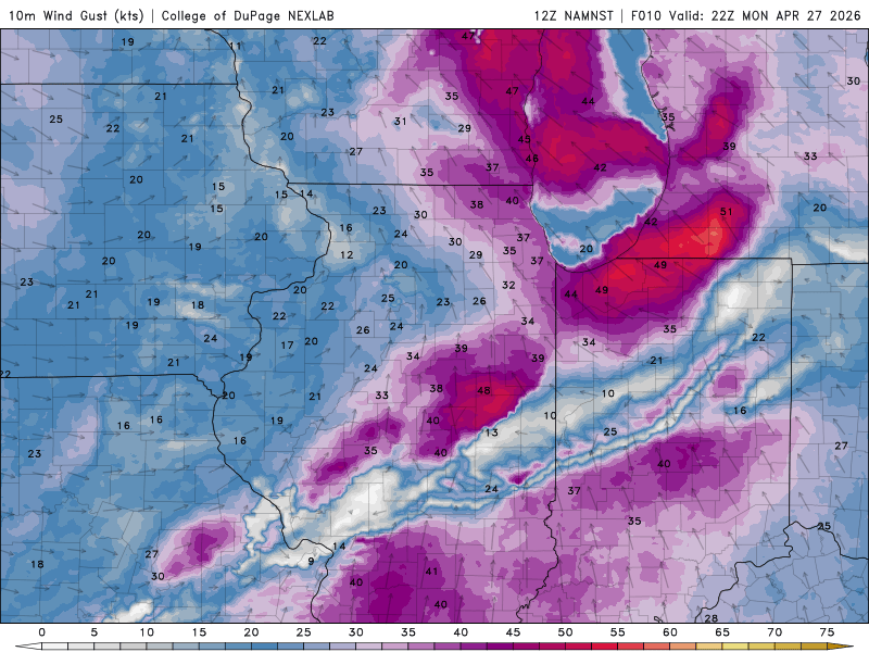
-
Potential Sever Weather Outbreak 4/27/2026
sbnwx85 replied to pen_artist's topic in Lakes/Ohio Valley
Jelly but will probably catch the very tail end of this late Monday -
Potential Sever Weather Outbreak 4/27/2026
sbnwx85 replied to pen_artist's topic in Lakes/Ohio Valley
Thinking another QLCS tornado threat this far east is best case scenario. -
What a difference 100 miles makes. We're nearly at 5 inches of rain for the month up here. 4.71" to be exact.
-
Record-breaking start to the severe weather season. Hope we can keep it going through August.
-
More good boomers out this way. Classic spring storm. Lightning strike believed to be the cause of a fire at a furniture store in Mishawaka.
-
Looks like some garden variety storms tomorrow evening across much of S. MI, IL, IN and OH.
-
Saw some lowering as a rotation signature moved to my northwest. Then the gust front hit with 50-55 mph winds. Lots of good CG lightning.
-
Tornado Warning!
-
Reminds me of the story of the 1965 outbreak and Northern Indiana issued a blanket tornado warning for every county because it couldn’t keep up. Completely different set up and reasoning but still gives me a chuckle
-
Hmm, well, I may be wishcasting again. From the current MCD: Eastward expansion of WW 131 will likely be needed in the coming hours across portions of eastern IL. Drier low-level conditions downstream across IN casts some uncertainty on how intense the line will be beyond roughly the 05-06 UTC time frame into IN, but convective trends will be monitored for the need for downstream watch issuance.
-
I count 16 Tornado Warnings from Oklahoma to Wisconsin right now. QLCS madness.
-
What a run. Congrats! I feel like this line is going to hold it together enough to get us a real strong gust front tonight.
-
Another Tornado Warning north of Rockford. Rockton getting rocked twice tonight. Like Night of the Twisters


