

sbnwx85
-
Posts
1,927 -
Joined
-
Last visited
Content Type
Profiles
Blogs
Forums
American Weather
Media Demo
Store
Gallery
Everything posted by sbnwx85
-

Winter 2025-26 Short Range Discussion
sbnwx85 replied to SchaumburgStormer's topic in Lakes/Ohio Valley
If you guys want to do a Sox/Tigers game sometime, I'd be down. Particularly on an Enhanced Risk day. -
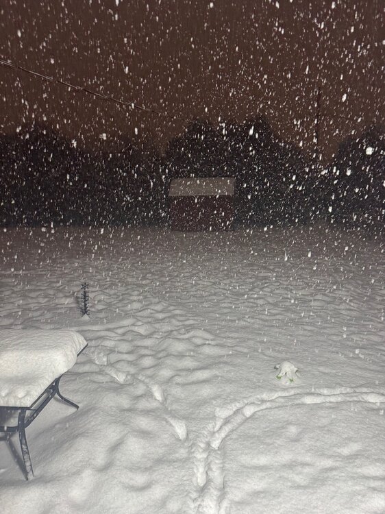
Picked up 3” at home this morning. Now at 3.6” for the month and 70.2” for the season. The official South Bend site saw 4.8”(!) bringing the seasonal total to 81.1”.
-
Winter 2025-26 Short Range Discussion
sbnwx85 replied to SchaumburgStormer's topic in Lakes/Ohio Valley
You’ll still be stuck hearing about Indiana’s great lake effect snows from me -
Ripping here. Eyeballing 3” so far. Two inch per hour rates with this band moving through.
-
Winter 2025-26 Short Range Discussion
sbnwx85 replied to SchaumburgStormer's topic in Lakes/Ohio Valley
Today's duster is just that. Coming down at a decent clip at times with visibility at 3/4 of a mile, but it's short-lived and not accumulating very efficiently. DAB seems like a good bet. HRRR shows an inch or two tomorrow before the lake kicks in. HRRR always overdoes lake-effect but it's showing 6+" over my area. I'd be impressed if we end up with 3". -
Historic day! I'm enjoying these. Thanks for sharing.
-
Winter 2025-26 Short Range Discussion
sbnwx85 replied to SchaumburgStormer's topic in Lakes/Ohio Valley
Duster incoming tomorrow. Followed by a DAB+ Friday. Lake effect looks paltry before another DAB+ Sunday. Stacking DABs -
Winter 2025-26 Medium/Long Range Discussion
sbnwx85 replied to michsnowfreak's topic in Lakes/Ohio Valley
Not excited to reveal the buried treasures left behind by the dogs since mid-January. -
Added about another inch. I’ll go measure later, but this is now the 18th day in a row with snow.
-
South Bend's high of 20 degrees today is the warmest in 7 days. South Bend spent 7 consecutive days below 20 degrees, the city's 9th-longest stretch in history. The 37.6" of snow in January (so far) is the 8th snowiest January on record. The official season snow total is 74.7" (north side of town). My backyard total is 65.9" (south side of town). By my calculations... this is the 7th snowiest winter through January on record. We'll see what the rest of the season holds!
-
Winter 2025-26 Medium/Long Range Discussion
sbnwx85 replied to michsnowfreak's topic in Lakes/Ohio Valley
I was about to say. The clipper and following lake-effect potential has piqued my interest... hopefully, slightly moderating temps will slow ice coverage on the lake. -
1/30-1/31 Lake Effect Snow Threat - SE WI, NE IL, and NW IN
sbnwx85 replied to A-L-E-K's topic in Lakes/Ohio Valley
Yeah, parameters weren't great on this side of the lake today, and we still ended up with 25:1 ratios. -
90 percent wind triple-hatched is going to be a big day.
-
Yeah, once the lake freezes over, we're all in the same boat hoping for system snow.
-
1/24-1/25 Major Winter Storm - S. IL, IN, and OH
sbnwx85 replied to A-L-E-K's topic in Lakes/Ohio Valley
Catchin strays left and right this week -
Finally someone willing to share real weather news:
-
A+ here but only for one reason
-
0.01" of precipitation recorded at South Bend today. 0.8" of snow. Just your typical 80:1 snow-to-liquid ratio.
-
Winter 2025-26 Medium/Long Range Discussion
sbnwx85 replied to michsnowfreak's topic in Lakes/Ohio Valley

-
I love winter but miss thunderstorms. The structure on this lake effect snow band is the best we’ll get for now.
-
Winter 2025-26 Short Range Discussion
sbnwx85 replied to SchaumburgStormer's topic in Lakes/Ohio Valley
IWX just issued a Winter Weather Advisory overnight tonight and Tuesday for the areas that got hit with lake effect. It’s to cover the 35 mph gusts that will blow this stuff around. We’re already getting gusts of 25-30 mph and it’s creating whiteout conditions at times. May get a true ground blizzard in rural areas, especially overnight. -
1/24-1/25 Major Winter Storm - S. IL, IN, and OH
sbnwx85 replied to A-L-E-K's topic in Lakes/Ohio Valley
Hit the daily double last night with lake effect and added another 3.4”. 6.8” storm total. 11” snow depth. It’s the fourth time this winter we’ve had double-digit snow depth. #blessed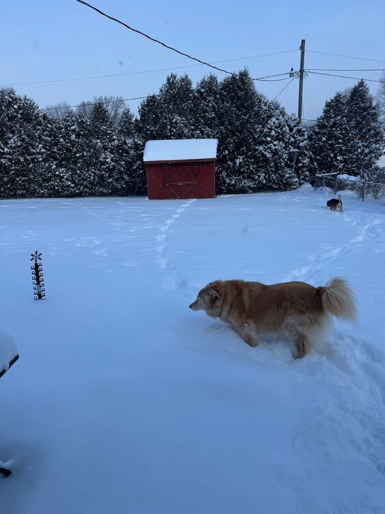
- 935 replies
-
- 10
-

-
1/24-1/25 Major Winter Storm - S. IL, IN, and OH
sbnwx85 replied to A-L-E-K's topic in Lakes/Ohio Valley
3.4” from the system. Standing by for the lake. -
1/24-1/25 Major Winter Storm - S. IL, IN, and OH
sbnwx85 replied to A-L-E-K's topic in Lakes/Ohio Valley
I see NYC has some mixing. Pretty happy about that -
1/24-1/25 Major Winter Storm - S. IL, IN, and OH
sbnwx85 replied to A-L-E-K's topic in Lakes/Ohio Valley
Eyeballing about 3” now. WSW are up just to my north and west for lake effect. The Advisory has been extended locally to account for the lake snow through tomorrow morning. Could see another 1-3”.


