sbnwx85
-
Posts
1,928 -
Joined
-
Last visited
Content Type
Profiles
Blogs
Forums
American Weather
Media Demo
Store
Gallery
Everything posted by sbnwx85
-

Winter 2025-26 Short Range Discussion
sbnwx85 replied to SchaumburgStormer's topic in Lakes/Ohio Valley
They were all over the Special Marine warning tho... -
Winter 2025-26 Short Range Discussion
sbnwx85 replied to SchaumburgStormer's topic in Lakes/Ohio Valley
my body is ready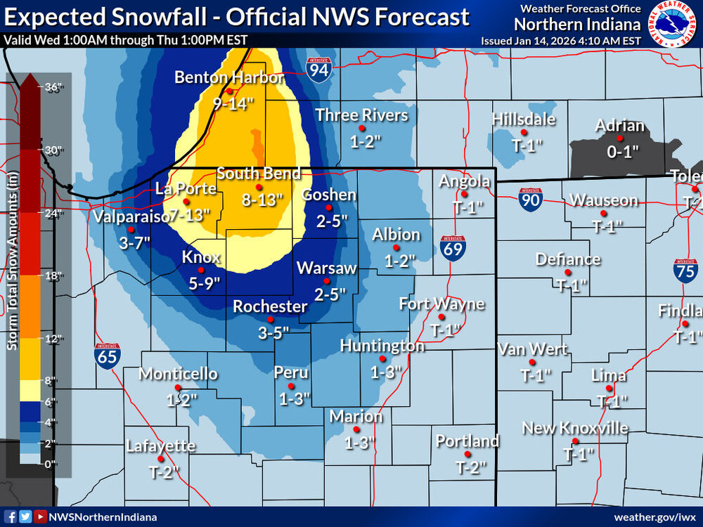
-
Winter 2025-26 Medium/Long Range Discussion
sbnwx85 replied to michsnowfreak's topic in Lakes/Ohio Valley
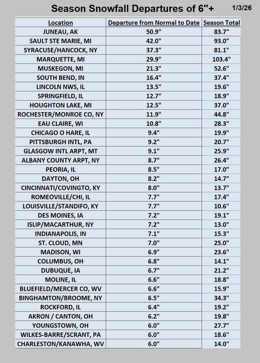
Incredible run. Put it in the Hall of Fame. While we obviously don't expect 40+" of snow, it's worth keeping an eye on if the signal for a massive storm is still there by the end of the week. Could be something special. -
Winter 2025-26 Short Range Discussion
sbnwx85 replied to SchaumburgStormer's topic in Lakes/Ohio Valley
-
Winter 2025-26 Short Range Discussion
sbnwx85 replied to SchaumburgStormer's topic in Lakes/Ohio Valley
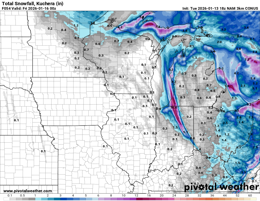
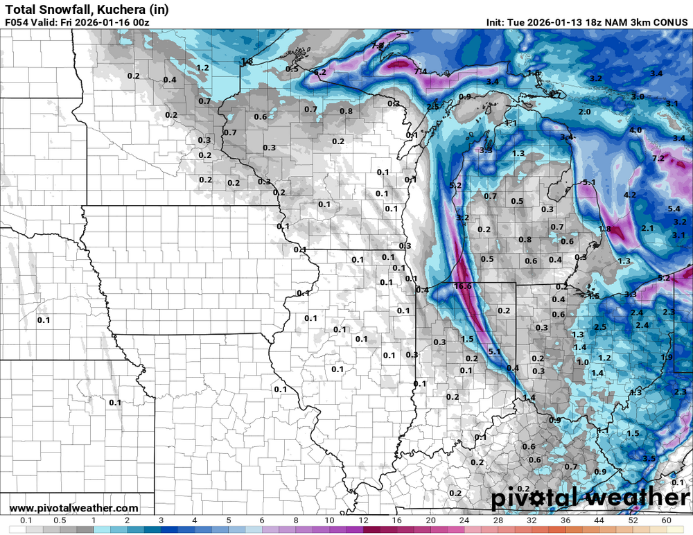
Locked and loaded for a significant lake effect snow event in North Central Indiana and extreme Southwest Michigan. Low end amount would be 3” if the band doesn’t set up overhead, but it will wobble before and after parking itself. High end would be 10”+. There may be a secondary band that sets up east of the main one. I just hope I don’t end up in between. -
Winter 2025-26 Medium/Long Range Discussion
sbnwx85 replied to michsnowfreak's topic in Lakes/Ohio Valley
A little concerned about a multi-band setup cutting potential big-time totals in half. But at least that spreads the wealth across Michiana a little more. NAM is really honing in on it. Still no room to complain, though. -
Winter 2025-26 Medium/Long Range Discussion
sbnwx85 replied to michsnowfreak's topic in Lakes/Ohio Valley
GFS moves the main band over South Bend. I'm all in. 12"+ or bust. -
Winter 2025-26 Medium/Long Range Discussion
sbnwx85 replied to michsnowfreak's topic in Lakes/Ohio Valley
Another 20 mile shift east would be ideal. -
Winter 2025-26 Medium/Long Range Discussion
sbnwx85 replied to michsnowfreak's topic in Lakes/Ohio Valley
The vibes would be immaculate. -
Winter 2025-26 Medium/Long Range Discussion
sbnwx85 replied to michsnowfreak's topic in Lakes/Ohio Valley
Somewhat surprisingly, the models keep pushing the main band closer to MBY. Getting interesting now. -
Winter 2025-26 Medium/Long Range Discussion
sbnwx85 replied to michsnowfreak's topic in Lakes/Ohio Valley
Liking the lake effect potential locally next weekend. -
Winter 2025-26 Medium/Long Range Discussion
sbnwx85 replied to michsnowfreak's topic in Lakes/Ohio Valley
Yeah. GFS and Euro both have it. GFS has it in more of IL. Euro is more Indiana. Looks like it’ll stay too far to my west but someone is going to cash in if it doesn’t wobble too much. -
Split job. Like summer time cells.
-
Winter 2025-26 Short Range Discussion
sbnwx85 replied to SchaumburgStormer's topic in Lakes/Ohio Valley
Best squalls will definitely miss South. Still might get some heavy bursts for a few minutes at a time. -
Rain changing to a rain/snow mix. Should get a DAB+ tonight and tomorrow.
-
Winter 2025-26 Medium/Long Range Discussion
sbnwx85 replied to michsnowfreak's topic in Lakes/Ohio Valley
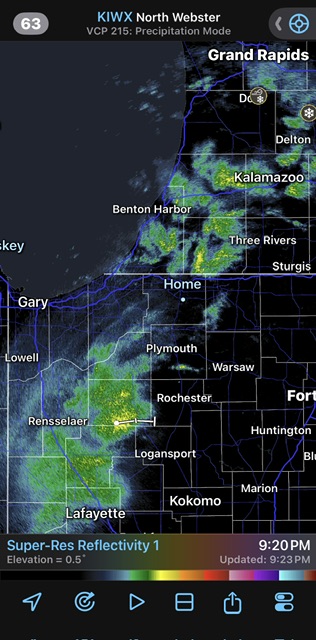
Hyper-local but the lake effect potential in NW Indiana looks real impressive Wednesday and Wednesday night. Michigan City to the IL/IN state line look like the early target. -
Ready2rumble Spring vibes today
-
it has been warm lately..
-
Might get my wish in about a week.
-
Winter 2025-26 Medium/Long Range Discussion
sbnwx85 replied to michsnowfreak's topic in Lakes/Ohio Valley
Yea i think it might be at least setting the table for a threat. Baby steps. -
Just begging for an arctic outbreak to get the lake-effect machine going. Would do numbers.
-
I had a mosquito in my house last night. wtf?
-
Winter 2025-26 Medium/Long Range Discussion
sbnwx85 replied to michsnowfreak's topic in Lakes/Ohio Valley
18z GFS would make the Bears/Packers game very entertaining. -
Amazing to see how long those Texas and California droughts last.
-
I guess I can’t complain yet.