sbnwx85
-
Posts
1,933 -
Joined
-
Last visited
Content Type
Profiles
Blogs
Forums
American Weather
Media Demo
Store
Gallery
Everything posted by sbnwx85
-

Nov 28-30th Post Turkey Day Winter Storm
sbnwx85 replied to Chicago Storm's topic in Lakes/Ohio Valley
UKIE stayed south FWIW. Is the Canadian delayed? -
Nov 28-30th Post Turkey Day Winter Storm
sbnwx85 replied to Chicago Storm's topic in Lakes/Ohio Valley
6z Euro held serve and the 6z GFS was another step in the right direction. Warm air nudging in too far north is definitely a concern moving forward, but so far, so good. -
Nov 28-30th Post Turkey Day Winter Storm
sbnwx85 replied to Chicago Storm's topic in Lakes/Ohio Valley
GFS is a step in the right direction. -
Nov 28-30th Post Turkey Day Winter Storm
sbnwx85 replied to Chicago Storm's topic in Lakes/Ohio Valley
Yea, I was thinking that based solely on climo, the rain/snow line ends up much further north than currently forecast. Not a bad look, though, for late November. As you say, hopefully a sign of good things to come. -
Nov 28-30th Post Turkey Day Winter Storm
sbnwx85 replied to Chicago Storm's topic in Lakes/Ohio Valley
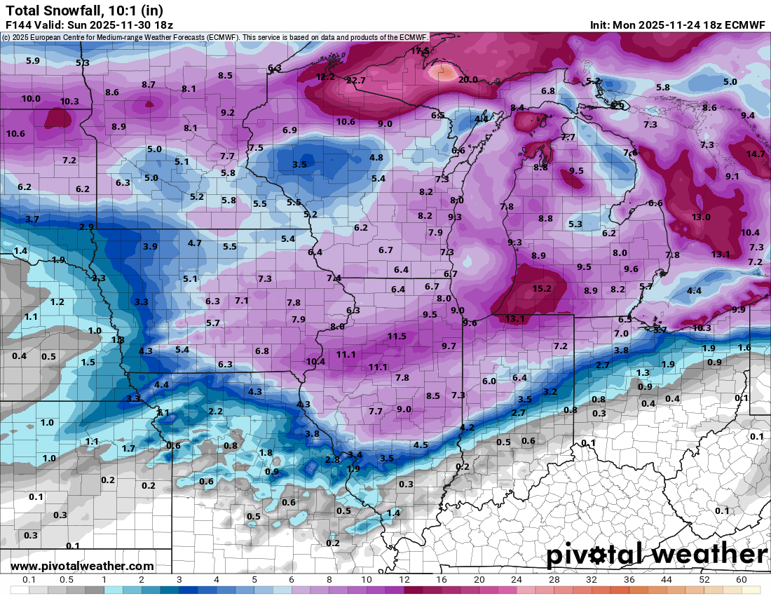
18z Euro a little further north again. Totals around N. IN and SW. MI includes the lake effect from Thursday.
-
Wednesday looks awfully windy. Gusts up to 50 mph across much of the sub.
-
Nov 28-30th Post Turkey Day Winter Storm
sbnwx85 replied to Chicago Storm's topic in Lakes/Ohio Valley
IWX favoring the foreign solutions early on. Friday through Monday... Some lake effect is likely to linger into Friday, possibly briefly shifting into NW Indiana for a period until the low level ridge axis finally passes through Friday night in response to the next area of low pressure taking shape. While models remain in agreement on a baroclinic zone establishing itself across the area over the weekend, timing and ptype issues persist, leading to an uncertain forecast for those likely travelling home from the holiday weekend. EC/GEM brings in precipitation during the day Sat with temp profiles cold enough for all snow through Sat night before shifting east. GFS delays precip till at least Sunday and maybe not till Monday, which would suggest more of a mix to possibly all rain. The current forecast leans towards the faster solution at this time with likely pops Sat/Sat night. As would be expected this far out, confidence in finer details is not overly high but worth watching. -
Fall 2025 Medium/Long Range Discussion
sbnwx85 replied to Chicago Storm's topic in Lakes/Ohio Valley
Euro pretty much the same as last night on snowfall. Maybe spreads the wealth a little more north. -
Fall 2025 Medium/Long Range Discussion
sbnwx85 replied to Chicago Storm's topic in Lakes/Ohio Valley
To be fair you are in peak form for November. -
Fall 2025 Medium/Long Range Discussion
sbnwx85 replied to Chicago Storm's topic in Lakes/Ohio Valley
I know @Chambanais pulling hard for the 00z Euro. -
Fall 2025 Medium/Long Range Discussion
sbnwx85 replied to Chicago Storm's topic in Lakes/Ohio Valley
The system Saturday is weaker and south. Then a cutter with rain which seems inevitable no matter what happens Saturday. -
Fall 2025 Medium/Long Range Discussion
sbnwx85 replied to Chicago Storm's topic in Lakes/Ohio Valley
12z GFS continues the trend. A long way to go but it’s a great hit for Iowa and the northern half of Illinois. Starts to lose steam into Michiana but I would take it.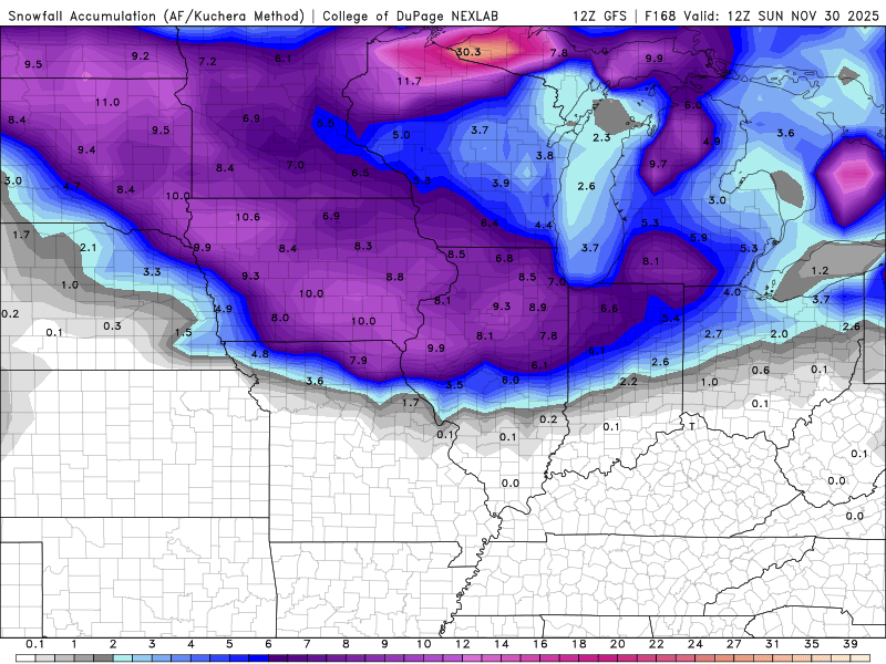
-
There was some sleet mixed in with the rain tonight. Temps in the upper 30's.
-
Still waiting for my first Snow Squall Warning. I'm surprised how many offices in the Midwest haven't issued one.
-
Snow pack went from 9” to 2” in just a couple days.
-
My penance for an early big dog is I’m socked under clouds and can’t see any aurora borealis
-
11/8-11/10 First Snow and Lake Effect Event
sbnwx85 replied to Geoboy645's topic in Lakes/Ohio Valley
You can make your own here! https://mesonet.agron.iastate.edu/plotting/auto/?q=207 Plot by state or CWA. The data goes back like 15 years or so. Happy plotting! -
11/8-11/10 First Snow and Lake Effect Event
sbnwx85 replied to Geoboy645's topic in Lakes/Ohio Valley
What a way to start the season! -
Same. Goodbye snow, hello sun.
-
11/8-11/10 First Snow and Lake Effect Event
sbnwx85 replied to Geoboy645's topic in Lakes/Ohio Valley
Padded another inch on the day at home. Saw closer to 3” at work. -
11/8-11/10 First Snow and Lake Effect Event
sbnwx85 replied to Geoboy645's topic in Lakes/Ohio Valley
A new snowfall record was set in South Bend Sunday. 8.2" of snow fell. The old record for this date was 8", in 1913. The jackpot in the IWX CWA appears to be Walkerton with 14". Round 2 is starting now . -
11/8-11/10 First Snow and Lake Effect Event
sbnwx85 replied to Geoboy645's topic in Lakes/Ohio Valley
We currently have 9.5” on the ground. 9” came from the lake effect yesterday. Could get another 6” this afternoon into tonight. -
11/8-11/10 First Snow and Lake Effect Event
sbnwx85 replied to Geoboy645's topic in Lakes/Ohio Valley
whiteout on the lakeshore. You can also drag the cursor back to see what the shot normally looks like. -
11/8-11/10 First Snow and Lake Effect Event
sbnwx85 replied to Geoboy645's topic in Lakes/Ohio Valley
Laporte getting wrecked thanks to the stalled mesolow. Current conditions at La Porte Municipal Airport (KPPO) Lat: 41.57°NLon: 86.73°WElev: 812ft. Heavy Snow Freezing Fog 30°F -1°C Humidity 100% Wind Speed W 16 G 35 mph Barometer 30.05 in Dewpoint 30°F (-1°C) Visibility 0.15 mi Wind Chill 19°F (-7°C) Last update 9 Nov 9:55 pm CST -
11/8-11/10 First Snow and Lake Effect Event
sbnwx85 replied to Geoboy645's topic in Lakes/Ohio Valley
Was in the “eye” but it’s starting to fill in. Heavy rates continued just 10 miles to my west and southwest. I’m sure they’ve cleared a foot. Sitting at 8” IMBY.