

sbnwx85
-
Posts
1,933 -
Joined
-
Last visited
Content Type
Profiles
Blogs
Forums
American Weather
Media Demo
Store
Gallery
Everything posted by sbnwx85
-
It was the frostiest morning of the season so far. If you squinted it kind of looked like snow.
-
Starting to get excited about the potential on this one.
-

Fall 2025 Medium/Long Range Discussion
sbnwx85 replied to Chicago Storm's topic in Lakes/Ohio Valley
Honored to present the first clown map of the season. We are so back.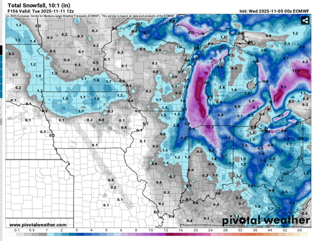
-
Fall 2025 Medium/Long Range Discussion
sbnwx85 replied to Chicago Storm's topic in Lakes/Ohio Valley
The first storm worth watching is showing up on the globals for the Sunday/Monday timeframe. Not thread-worthy yet, as there's still a lot to work out, but someone in the sub may see their first flakes/(sticking snow??) of the year. EDIT: Just saw ya'll talking about it in the November thread. -
Yeah, probably a couple feet in some spots. A promising sign of how primed the lake is again this season.
-
Nice rain bands coming off LM today.
-
Seeing quite a few hail reports in Michigan and N. Indiana.
-
Already up to 1.5”. Call looking good. What we’ve lacked in severe weather locally we’ve made up for in long-duration thunderstorms.
-
I think we can squeeze out a couple inches of rain this weekend.
-
Frost Advisory tonight. It'll be "low tire pressure light" season before you know it.
-
The things I like most about fall don't happen nearly often enough, but some of the best severe weather/wind events have occurred in October/November. Unfortunately, they're few and far between. Examples: 1. 10/24/01 Tornado outbreak in Northern IN 2. 10/18/07 Nappanee EF3 tornado 3. 10/26/10 High Wind Event 4. 11/17/13 Tornado Outbreak 5. 11/5/22 High Wind Event November, of course, can also bring an occasional big dog, but that's even more rare.
-
Under a quarter inch of rain so far here. Michigan doing much better.
-
It seems I say it most years but this warm fall should make for a rockin lake-effect season. Most of the lake-effect belts north and east of me cashed in last year. We just couldn't get the good dynamics on the southern end of Lake Michigan last winter. Too many glancing blows. Hoping for better arctic blasts this winter.
-
Scored two thunderstorms within a couple hours of each other tonight. Best rains were west and south of me but I still managed about 3/4 of an inch.
-
Rain is light but it’s thundering which is all I ever really need.
-
I did some digging and turns out it’s something called “rain”. It’s a relatively common weather phenomenon across some parts of the world. Exciting to see it so close by!
-
There are a lot of green, yellow and orange returns showing up on radar in southeast Wisconsin. I’ll investigate what it could be.
-
Edit: Low officially was 40. Tied daily record low from 1986.
-
Low at SBN was 41 but I had 39 on my thermometer at home.
-
Farmers probably happy to get harvest started
-
I woke up to 66 in the house. I considered turning on the heat but I just can't bring myself to do it in August.
-
Had a heavy lake-effect rain shower move through late this morning. Was hoping for one rumble to make it a rare lake-effect thunderstorm but no such luck.
-
When's the last time we had a legit fall tornado outbreak? The last few late-season outbreaks have been in December.
-
I see the theory but in reality it doesn’t really matter this time of year. As long as we don’t stay 20 degrees below normal until winter… and the winter brings arctic blasts over the lake in Nov, Dec, Jan we are good. Locally our best lake effect events come in January, historically, as long as the lake isn’t frozen over. But that would be the result of a frigid December.
-
Cranking the lake effect machine in late August. It’s gotta be a good sign for winter.


