sbnwx85
-
Posts
1,933 -
Joined
-
Last visited
Content Type
Profiles
Blogs
Forums
American Weather
Media Demo
Store
Gallery
Everything posted by sbnwx85
-
Tornado Watch coming for much of Central and Southern Illinois.
-
Yeah, 12z HRRR looks a little better but still messy. Hopefully we avoid too much crapvection before the main line moves through. Optimistically… I can hope whatever pops ahead of the line is rotating and interacting with the leftover boundaries from the storms that just came through here.
-
Watch for some strong winds behind the line of storms today, particularly around the mesolow.
-
00z NAM and HRRR have explosive storm development just to my southwest around 21z tomorrow. Shades of 3/30/25 which produced 60-70 mph gusts and small tornadoes across N. Indiana and S. Michigan. The tree damage was significant across the area… and that was without leaves on the trees.
-
Minnesota folks cashing in. Happy for you guys. Better than smoke.
-

2025 Short Range Severe Weather Discussion
sbnwx85 replied to Chicago Storm's topic in Lakes/Ohio Valley
I've started a thread for the week: -
A nice multi-day setup across the region. Currently, a Tornado Watch is up for much of Minnesota. But most of us are focused on the 18th. There is good potential for a severe complex of storms to plow through the most populated areas of our subforum. ...THERE IS A SLIGHT RISK OF SEVERE THUNDERSTORMS FROM LOWER MICHIGAN SOUTHWESTWARD INTO OKLAHOMA... ...SUMMARY... Scattered thunderstorms with severe wind gusts and hail are expected on Wednesday from the southern Plains to the southern Great Lakes, and over a small part of the Mid Atlantic. ...Synopsis... On Wednesday, an upper trough will move from the central Plains across the mid to upper MS Valley, with a lead wave moving from MO into Lower MI. A surface low is expected from eastern IA into lower MI during the day, with a trough extending southwestward across IL, MO, and OK. A very moist and unstable air mass will exist ahead of this main front with upper 60s to lower 70s F dewpoints. To the east, a weak surface trough is forecast to develop over the Mid Atlantic, where strong heating will lead to an unstable air mass beneath modest southwest flow aloft around western Atlantic high. ...MI southwestward into OK... Scattered storms may be ongoing Wednesday morning from IA into MO and northeast OK, with remnant MCS activity. It appears the greatest ascent will move across northern areas coincident with the shortwave trough, from northern IL into lower MI. Here, shear profiles will likely support supercells, including hail and perhaps tornado threat. Farther south, stronger instability and PWAT will exist along the front but with weaker shear. Substantial convection is expected with areas of damaging winds likely. Some of these storms may move south to southwest due to propagation. Given steep midlevel lapse rates, sporadic hail may occur as well.
-
2025 Short Range Severe Weather Discussion
sbnwx85 replied to Chicago Storm's topic in Lakes/Ohio Valley
Day 5 slight risk for much of us. -
Currently 72/66 at SBN but it feels much swampier than that. Maybe the recent dry dew points make it seem muggier.
-
Storms are firing overhead. Just some rain and a rumble of thunder at work. It looks like I missed out on the goods at home. Someone mPing'd pea-sized hail by my house.
-
Mid-60s and overcast. Best tranquil weather. No sweating and no sun in your eyes. Obviously, the best overall weather is a blizzard in winter and a 90+ mph downburst in summer.
-
Appears to be wafting this way https://www.star.nesdis.noaa.gov/GOES/sector_band.php?sat=G19§or=cgl&band=GEOCOLOR&length=24
-
-
That’s a good point, I think. Maybe to add to that, I’m not sure what farmers in Central Illinois are doing but there have been about four springtime “dust storms” over the last decade due to wind picking dirt while farmers are out in the field. And they’ve caused major problems for drivers on the interstates.
-
Nice, steady rain here. Good for the garden.
-
We have a reporter working on a story today about the crops ruined by the dust storm across portions of North Central Indiana. Soybeans were already planted and now farmers are re-planting this week.
-
Ope.
-
It's wonderful.
-
It’s wild tracking the correlation coefficient about 2 miles wide wobbling like the eye of a hurricane.
-
Yea big dud here. Excited for the miss south tomorrow.
-
Waterspout?
-
Low end severe thunderstorm warning issued here. Should at least get some boomers.
-
Going to be a real close call. Working on the north side of the county may be the only reason I see a storm.
-
Areas affected...Parts of northeastern into central Illinois Concerning...Tornado Watch 255... Valid 160036Z - 160130Z The severe weather threat for Tornado Watch 255 continues. SUMMARY...Severe hail and damaging winds are the primary concern, though the tornado risk could increase with any sustained supercells over the next couple hours. DISCUSSION...Severe storms are tracking eastward along the north/south-oriented dryline feature across northeastern/central IL. Storms have increased in intensity/coverage over central IL (along the southern portion of the line), where large-scale ascent in the exit region of a midlevel jet is maximized amid strong buoyancy (around 3000 J/kg MLCAPE) and minimal inhibition. Given the strong buoyancy and 60 kt of 0-6km shear oriented perpendicular to the line, these storms will continue to pose a risk of severe hail and damaging winds. Sufficient low-level shear (around 30-kt 0-1km per ILX VWP) and rich boundary-layer moisture will also support a tornado risk, especially with any established supercell structures. Farther north into northeastern IL, storm coverage has been limited owing to weaker large-scale ascent. However, as the dryline feature intercepts the old lake breeze boundary, an uptick in severe potential will be possible over the next hour or two. Ample buoyancy/low-level moisture and sufficient low/deep-layer shear will support supercell structures capable of damaging winds, large hail, and a tornado or two. ..Weinman.. 05/16/2025
-
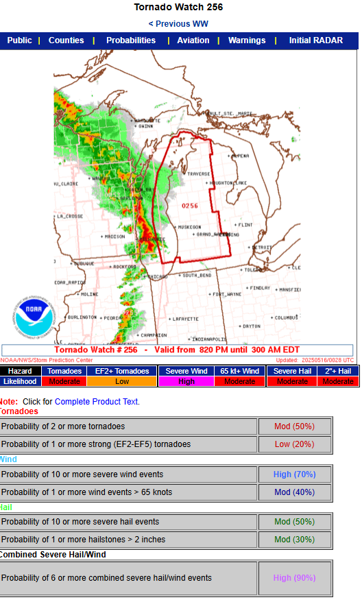
URGENT - IMMEDIATE BROADCAST REQUESTED Tornado Watch Number 256 NWS Storm Prediction Center Norman OK 820 PM EDT Thu May 15 2025 The NWS Storm Prediction Center has issued a * Tornado Watch for portions of Lower Michigan Lake Michigan * Effective this Thursday night and Friday morning from 820 PM until 300 AM EDT. * Primary threats include... A few tornadoes possible Scattered damaging winds likely with isolated significant gusts to 80 mph possible Scattered large hail and isolated very large hail events to 2 inches in diameter possible SUMMARY...Intense thunderstorms will spread east-northeastward this evening and overnight across much of Lower Michigan while posing a threat for scattered to numerous severe/damaging winds. Peak gusts may reach up to 70-80 mph. A few tornadoes may also occur within the line of convection. Large hail will be possible with any embedded supercells. The tornado watch area is approximately along and 60 statute miles east and west of a line from 60 miles north of Traverse City MI to 10 miles southwest of Kalamazoo MI. For a complete depiction of the watch see the associated watch outline update (WOUS64 KWNS WOU6). PRECAUTIONARY/PREPAREDNESS ACTIONS... REMEMBER...A Tornado Watch means conditions are favorable for tornadoes and severe thunderstorms in and close to the watch area. Persons in these areas should be on the lookout for threatening weather conditions and listen for later statements and possible warnings.