sbnwx85
-
Posts
1,933 -
Joined
-
Last visited
Content Type
Profiles
Blogs
Forums
American Weather
Media Demo
Store
Gallery
Everything posted by sbnwx85
-

11/8-11/10 First Snow and Lake Effect Event
sbnwx85 replied to Geoboy645's topic in Lakes/Ohio Valley
Vort max is coming ashore now. Band should shift towards Illinois. Strong meso low and a Lake Huron connection creating decent snows across Western Michigan. That should come south and keep the snow falling off and on until about midnight locally. -
11/8-11/10 First Snow and Lake Effect Event
sbnwx85 replied to Geoboy645's topic in Lakes/Ohio Valley
7.5” from today. 3.5” in the last hour. Storm total is 9” including yesterday’s system. -
11/8-11/10 First Snow and Lake Effect Event
sbnwx85 replied to Geoboy645's topic in Lakes/Ohio Valley
2” in the last half hour. My math isn’t great but I think that’s 4”/hour. Bonkers stuff. The rest of the winter is going to be boring after this. -
11/8-11/10 First Snow and Lake Effect Event
sbnwx85 replied to Geoboy645's topic in Lakes/Ohio Valley
Snow rates have exploded since sunset. Went from one inch per hour to at least two… maybe three. -
11/8-11/10 First Snow and Lake Effect Event
sbnwx85 replied to Geoboy645's topic in Lakes/Ohio Valley
Absolutely ripping under this band. I went to pick up pizza for me and gf. Left with moderate snow, 1/2 mile visibility and mostly clear roads. Coming home with heavy snow, 1/4 mile visibility and snow packed roads.
- 213 replies
-
- 17
-

-
11/8-11/10 First Snow and Lake Effect Event
sbnwx85 replied to Geoboy645's topic in Lakes/Ohio Valley
Got an inch in about an hour. 5-10” seems like a good bet before the band completely shifts west overnight. -
11/8-11/10 First Snow and Lake Effect Event
sbnwx85 replied to Geoboy645's topic in Lakes/Ohio Valley
A little ahead of schedule but we are rocking. -
11/8-11/10 First Snow and Lake Effect Event
sbnwx85 replied to Geoboy645's topic in Lakes/Ohio Valley
-
11/8-11/10 First Snow and Lake Effect Event
sbnwx85 replied to Geoboy645's topic in Lakes/Ohio Valley
I’m liking the trends on the HRRR locally. It keeps the main band overhead for several hours this late afternoon and evening before the mesolow swings through. Tomorrow afternoon and evening will have to be closely watched out here for round 2. -
11/8-11/10 First Snow and Lake Effect Event
sbnwx85 replied to Geoboy645's topic in Lakes/Ohio Valley
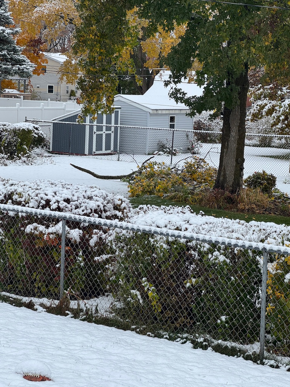
Just 1.5” took out a good-size tree limb next door.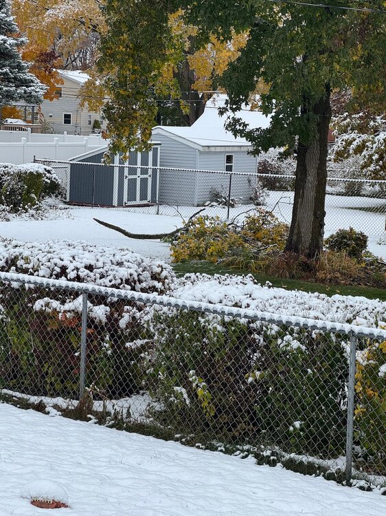
-
11/8-11/10 First Snow and Lake Effect Event
sbnwx85 replied to Geoboy645's topic in Lakes/Ohio Valley
Oh and quite a snippet from the LOT AFD By the time the lake effect ends on Monday, total snow amounts will vary considerably across short distances. Where the snow bands are most intense, total snow accumulations of 12 to 18 inches are expected with a ceiling of 2 to 4 feet if snow bands end up stationary. This threat appears to be most pronounced over Cook county, but may extend to Lake County Illinois and Lake County Indiana, as well. -
11/8-11/10 First Snow and Lake Effect Event
sbnwx85 replied to Geoboy645's topic in Lakes/Ohio Valley
Potential for historic snows in the city! The mesolow looks to come ashore out here in Indiana (which keeps me in the game for a potential big dog) but it will be what dramatically shifts the main band into Chicago. Considering how deep the cold air is and how warm the lake is, expect at least 3” per hour rates. This is an extraordinary set up, so 6-8” per hour isn’t out of the question at times. I’ve only experienced 4” per hour snows once in my life and it was bonkers. It’s exciting but be ready to have your heart broken. This is Game 7 of the World Series, tied at 4-4 in extra innings. It could be glory or it could be nothing. The band and mesolow will ultimately do what they want but this is as good of a setup for Chicago as I’ve ever seen. I’m hoping the band shifts back east and holds together for a few more inches on Monday. -
11/8-11/10 First Snow and Lake Effect Event
sbnwx85 replied to Geoboy645's topic in Lakes/Ohio Valley
1.5” from the system. Hopefully it doesn’t all melt before the lake effect kicks in. -
11/8-11/10 First Snow and Lake Effect Event
sbnwx85 replied to Geoboy645's topic in Lakes/Ohio Valley
It took a couple of hours but we finally started seeing accumulation. DAB+ -
11/8-11/10 First Snow and Lake Effect Event
sbnwx85 replied to Geoboy645's topic in Lakes/Ohio Valley
All snow now. -
11/8-11/10 First Snow and Lake Effect Event
sbnwx85 replied to Geoboy645's topic in Lakes/Ohio Valley
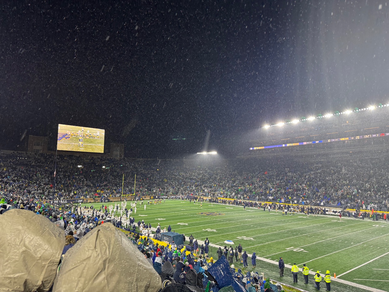
At the Notre Dame game and snow is already mixing in with the rain.
- 213 replies
-
- 10
-
-
11/8-11/10 First Snow and Lake Effect Event
sbnwx85 replied to Geoboy645's topic in Lakes/Ohio Valley
TV mets hanging onto the warm ground concerns which won’t be a factor at night with high rates. Lake snows have dropped 18” this time of year with less favorable synoptics. -
Yeah, even on this side of the lake you don’t really start getting your hopes up until the band is overhead
-
Winter Storm Watches are up along the southern shore of Lake Michigan from Cook County, IL to Berrien County, MI. 6-12” possible. Probably more in Porter and LaPorte Counties. Thundersnow possible. Rates of 2-4” per hour. The IWX forecast discussion is one of the best reads in a long time. Winds over 35+ mph, 6+” of snow and leaves on the trees are going to be a perfect recipe for major tree damage. The TV Mets going super conservative due to ground temps are going to have to backtrack big time. The rates and timing will overcome a warm ground in no time. This are going be a memorable event for localized areas.
-
Although putting 6” down before the lake effect even kicks in is crazy work.
-
A reminder that NAM stands for Never A Mistake.
-
NAM dumps overhead for a few hours. In another month that's like three feet of snow, but I'd take 8 in early November. Still lots of leaves on the trees so whoever gets dumped on will also have tree damage and power outages to deal with.
-
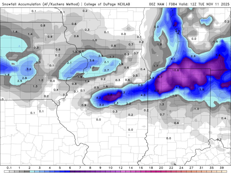
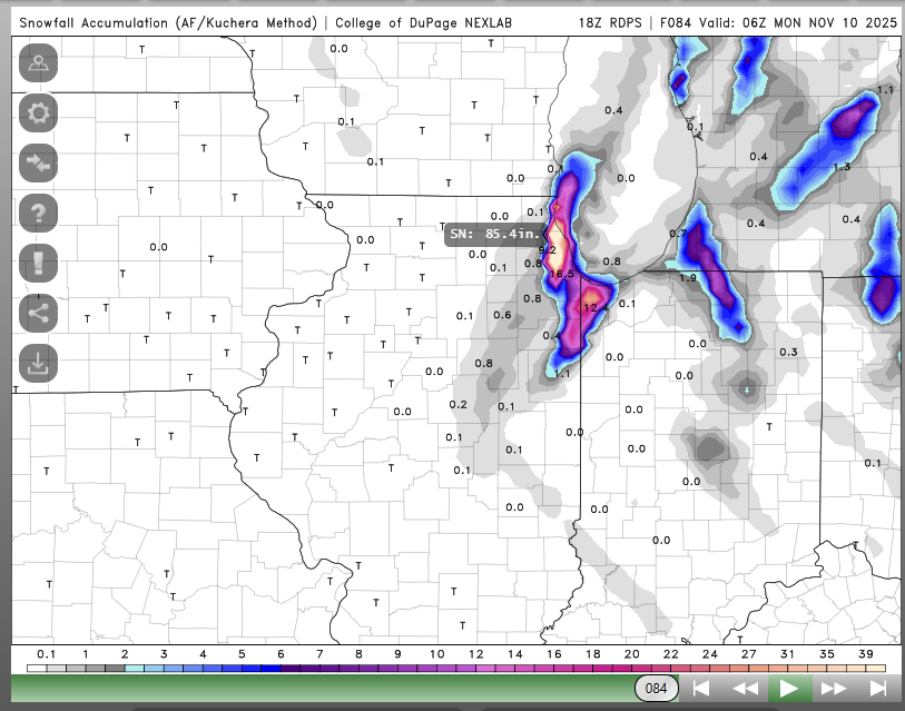
RGEM says congrats, Chicago. This might set some kind of record. /s In all seriousness, Pivotal's output isn't as wild (obvious error in COD's algorithm), spitting out 10" in Chicago thanks to an intense mesolow crashing ashore. NAM and Euro appear to be picking up on a mesolow, as well, but it's a little slower -- coming onshore overnight Sunday. The timing of this early-season lake-effect event favors localized "big dog" totals, as it occurs at night. Plus, lots of deep cold air and a possible Lake Superior connection. Of course, where the bands set up/mesolow forms will be key. Happy tracking!
-
https://www.wpc.ncep.noaa.gov/Prob_Precip/ Speaking of updates, WPC has a good one for its snowfall/ice probability maps.
-
Getting damn near giddy. More persistent lake-effect snow appears most likely during the Sunday night through Monday evening time frame as very cold north- northwesterly low level flow sets up along Lake Michigan with H85 temperatures plunging to near -10 deg C above a still very warm lake surface (Lake-H85 difference around 20 C), courtesy of yet another (this time rather vigorous) short wave diving across the western Great Lakes during the day on Sunday. While it is difficult to iron out any specifics at this time range, this does appear to be something to watch over the next several days. The latest NBM shows roughly 60 percent probabilities of 4+ inches of 24-hour snowfall accumulation across Berrien, La Porte, and St. Joseph (IN) counties. Further, latest ECMWF EFI shows values of around 0.9 downwind of LM with Shift of Tails (SOT) values of 2 to 5. This would generally indicate greater confidence in potential for a more significant event relative to climatology. Stay tuned.