

Chinook
-
Posts
10,933 -
Joined
-
Last visited
Content Type
Profiles
Blogs
Forums
American Weather
Media Demo
Store
Gallery
Everything posted by Chinook
-
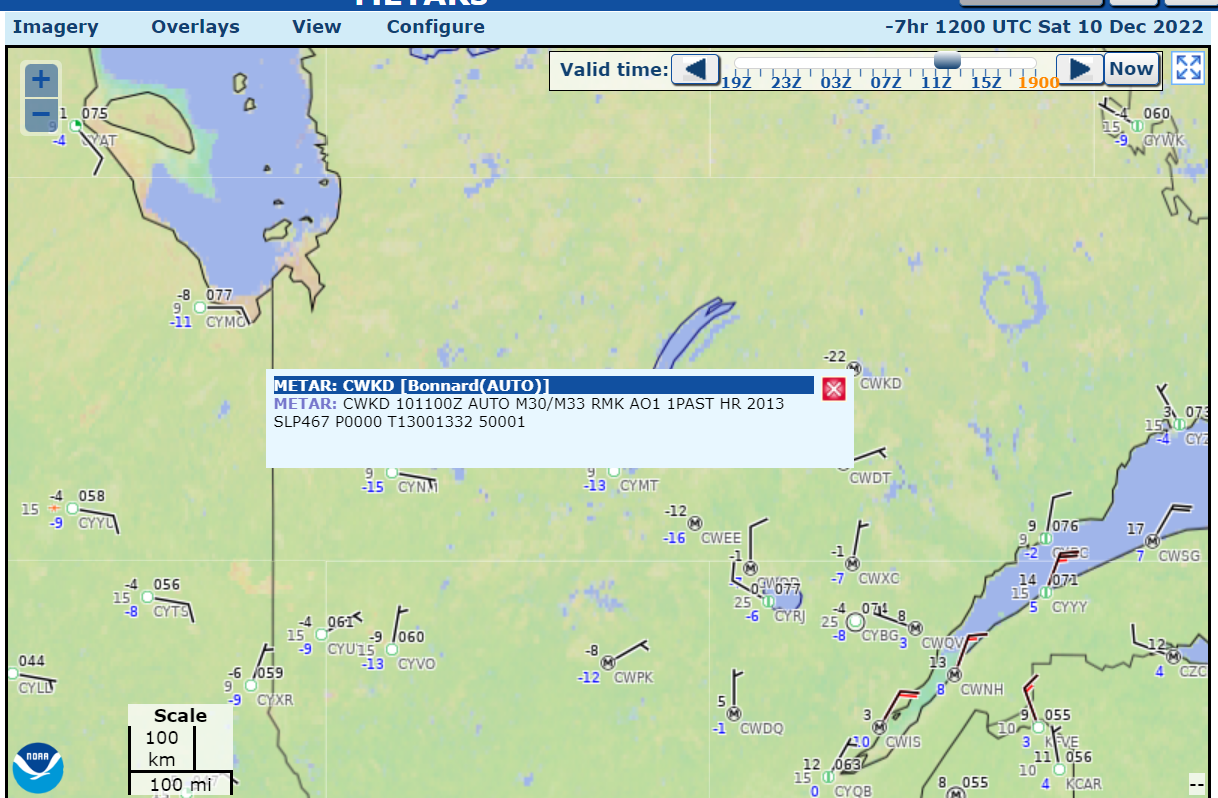
sea level pressure: 1046.7mb and -22 degrees F.

-

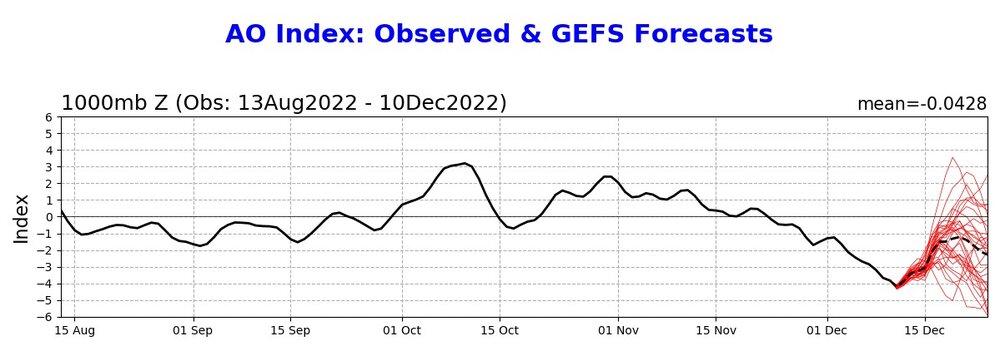
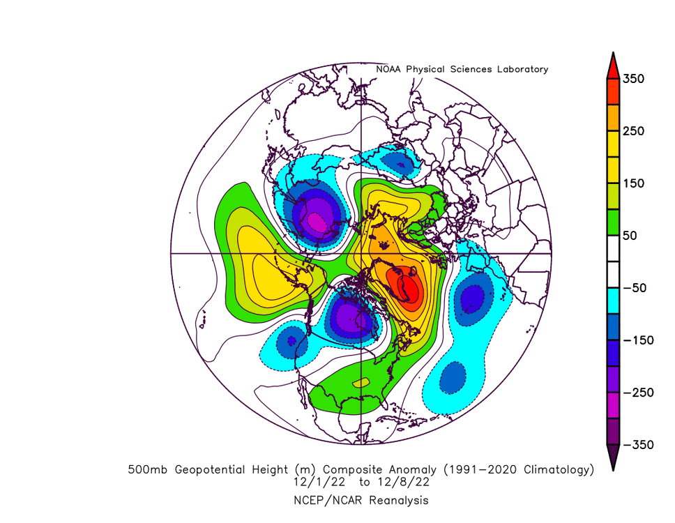
Winter 2022/23 Medium/Long Range Discussion
Chinook replied to Chicago Storm's topic in Lakes/Ohio Valley
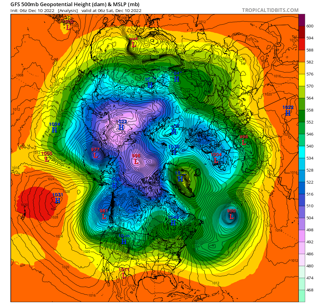
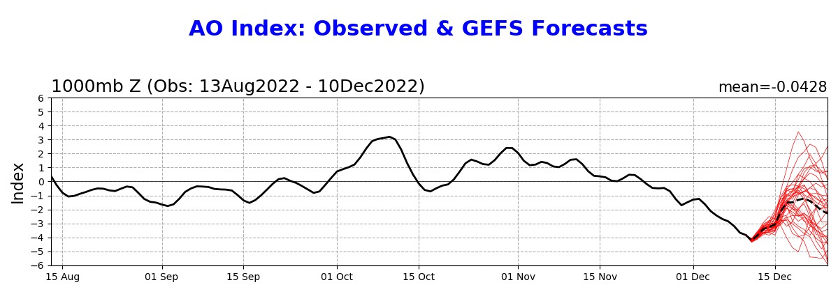
well I guess the NAO is negative, specifically if think that one of the ways to express the NAO index is the SLP anomaly in Ponta Delgada, Azores Islands, minus the SLP anomaly in Iceland and the AO index, which is effectively calculated by SLP (really, 1000mb heights) shows a very negative value today December 1-8 analysis shows a strong negative NAO value and yet the eastern USA had higher than normal heights at 500mb
-
Here are observations from yesterday's high winds and dust storm. The cold front drove a wall of dirt, which shows up on the colorized visible satellite image shown below. Apparently there are dust storm polygons. (Who knew?)
-
11/29/22 MDT Outlook Issued -- Regional outbreak possible.
Chinook replied to CryHavoc's topic in Central/Western States
I actually don't know if this was a confirmed tornado, but hey, huge hole in the storm. -
11/29/22 MDT Outlook Issued -- Regional outbreak possible.
Chinook replied to CryHavoc's topic in Central/Western States
tornado video tweeted by @LandonWX10 on twitter -
11/29/22 MDT Outlook Issued -- Regional outbreak possible.
Chinook replied to CryHavoc's topic in Central/Western States
large and complicated velocity signature with reported multi-vortex tornado
-
11/29/22 MDT Outlook Issued -- Regional outbreak possible.
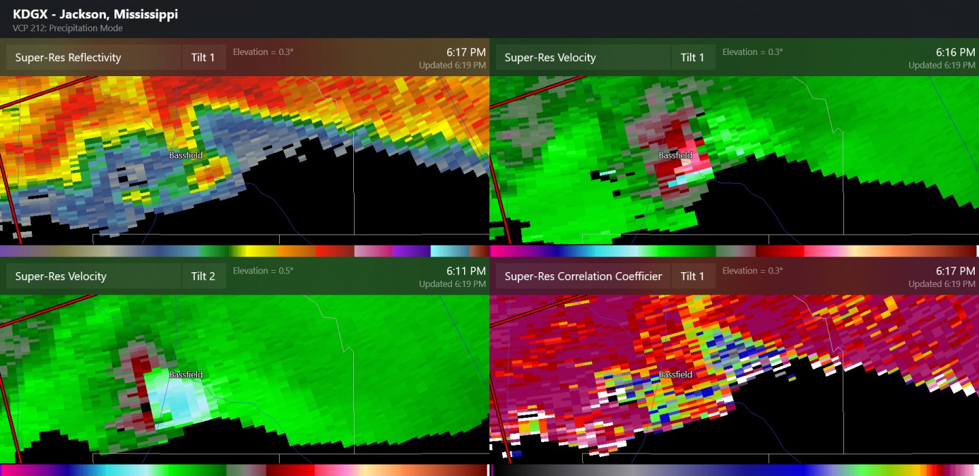
Chinook replied to CryHavoc's topic in Central/Western States
confirmed tornado as of about 6:05 or 6:10 eastern time, Bassfield -
Even though there is a strong emphasis on tornadoes today, the SPC has meteorologists issuing MDs for snow in the Midwest.
-
11/29/22 MDT Outlook Issued -- Regional outbreak possible.
Chinook replied to CryHavoc's topic in Central/Western States
pretty much all convection-allowing models have numerous discrete thunderstorms at 06z tomorrow night -
11/29/22 MDT Outlook Issued -- Regional outbreak possible.
Chinook replied to CryHavoc's topic in Central/Western States
The Day-3 enhanced outlook is very concerning for this region. Maybe this could go into a moderate risk outlook for tornadoes and wind when we get to the event. The severe weather parameters such as the STP will greatly increase from 21z to 06z. The NAM and GFS have much different values for the 850mb wind in the region in this time frame, as the NAM has up to 60kt in E Arkansas but the GFS is lower. Note the GFS has values of STP of 1.0-2.0 in the Louisiana area. That's still impressive, but not as impressive as this chart. -
NWS web page "weather story"
-
The global models have some general agreement on this. There is an open 500mb trough powering up this snow event on possibly Tuesday.
-
looks pleasant and sunny, with a minimum of snow in this field
.thumb.jpeg.25e74bddcd7f820bb9c23d6e4410d24d.jpeg)
-
Happy Thanksgiving. 72 years ago, Thanksgiving Day was on the 23rd of November. On the 24th, deep upper level low was over the central USA. This drove an arctic air mass into the Ohio Valley. A surface low pressure intensified in North Carolina, then moved north and stalled in Ohio. Heavy snow and blizzard conditions hit Ohio. This was one of the most impactful weather events for northern West Virginia of all time. http://greatlakes.salsite.com/maps/nov2327_1950_sfc_loop.gif
-
Winter 2022/23 Short/Medium Range Discussion
Chinook replied to Chicago Storm's topic in Lakes/Ohio Valley
00z ECMWF has a low in Illinois with 34 degrees, wind, and snow at St. Louis on Black Friday. Essentially no model has been very consistent with what's happening around Thanksgiving/Black Friday. anybody know where it's going to rain or snow?
-
It's kind of funny the 10:1 to 12:1 is still quite common even when the models with Kuchera snow ratios calculations say that won't happen. Another idea I had over the last few years. With streets that don't receive any plowing or salting, the total liquid equivalent of the snow is pretty much the main factor for how much snow/ice is packed onto the street after a day or so, given temperatures below freezing. Then, of course if it's 60 degrees the next day, that total liquid equivalent goes into puddles quickly.
-
looks like 2.0-3.5" at Fort Collins and Loveland with maybe 10:1
-
Historic Lake Effect Event?! 11/17-11/21
Chinook replied to BuffaloWeather's topic in Upstate New York/Pennsylvania
In all respect to Jeb walking, I have called this activity "Wethafella Walking. " At the time, Wethafella was a retired, or nearly retired guy from Boston who went out on fun walks during blizzard conditions in Boston, back in the days when I was relatively new to the forums. -
Historic Lake Effect Event?! 11/17-11/21
Chinook replied to BuffaloWeather's topic in Upstate New York/Pennsylvania
1/8 mile measured visibility -
Winter 2022/23 Lake Effect Snow Thread
Chinook replied to Chicago Storm's topic in Lakes/Ohio Valley
It reminds me of a hurricane, although possibly only 10 kt to 30 kt winds within the circulation(s). One other mesolow was over by Alpena earlier. -
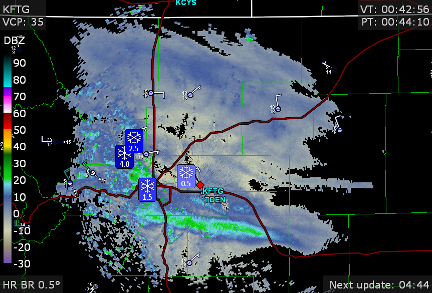
There have been snow reports of 1.5" to 4". The temperature is 16 degrees in Denver. There are light snowfall rates, with a few bits of heavier snow rates around Boulder and south Denver.
-
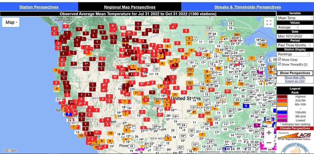
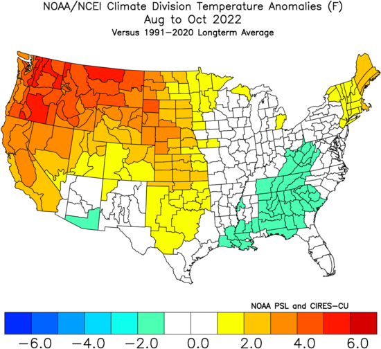
This shows the temperature ranking on the late summer to fall heat wave: #1 warmest Aug to Oct, basically for Washington, Oregon, Idaho, Montana.
-
There is a winter weather advisory for the Front Range
-
Historic Lake Effect Event?! 11/17-11/21
Chinook replied to BuffaloWeather's topic in Upstate New York/Pennsylvania
NWS-WPC has 2"-3" of total QPF (120 hours) just offshore from Jamestown NY/Erie PA with 1.9"-2.1" for Erie and the Southtowns of Buffalo. -
Here are the local storm reports for the last 48 hours.


.jpeg.3b6db5101f74243f657cc91ac3d28d31.jpeg)
