Chinook
-
Posts
10,933 -
Joined
-
Last visited
Content Type
Profiles
Blogs
Forums
American Weather
Media Demo
Store
Gallery
Everything posted by Chinook
-
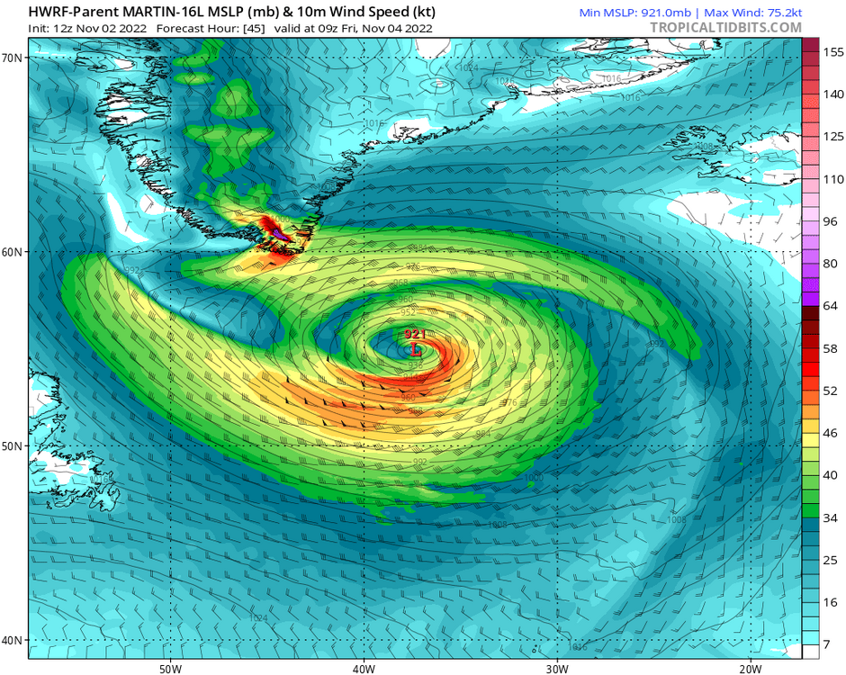
Hurricane Martin getting caught by the cold air aloft. The GFS has 100 kt winds close to the ocean surface as this transitions.

-
HRRR has band of moderate snow/rain at Denver at 22z (4:00PM) tomorrow (temperature is 37)
-
75-80 degrees up north
-
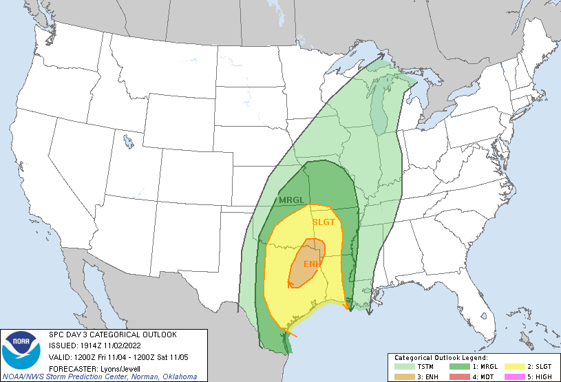
day 2/day 3
-
Models have this merging with the mid latitude trough to produce maybe 927mb near Greenland. I wonder if that's the sort of freak storm, that, sunk dozens of ships of Europeans going back and forth to North America in the 1700s and such. HWRF- large grid
-
I found one prickly pear cactus on the Oak Openings soil years ago, not sure if it was early 2000s or something. Then I moved to a place that had prickly pear cactus, (and only that type.) The Rocky Mountain foothills at ~5100 ft had prickly pear cactus.
-
Yes. It's kind of funny to see the perhaps specifically-planted white pine in there. The forest shouldn't have pine. It was my favorite outdoor place before the Rocky Mountains.
-
Here are some pics from about a week ago. I haven't seen the hardwoods change color for the last 16 years. The western cities had a relative few maples in town, but overall there were non-hardwoods. There were ash trees in the west, which apparently aren't here due to the emerald ash borer. The cottonwoods out west were bright yellow if you didn't get a nasty frost, but also could become brown quickly. The oranges were kind of absent out west. The aspens planted in town were a nice yellow. It was occasionally nice to see the aspens in the natural mountain environment, but the thing is, I missed the maple trees!
-
The 06z NAM has 1-4" of snow east of Greeley and east of DIA this week. The GFS/Canadian/ECMWF have amounts around 1" near and east of I-25.
-
Guess what? Maybe time for a winter thread. The models have some agreement on this cold air mass and higher chance of snow for the mountains on Thursday night, with some possibilities for snow on the Plains.
-
Major Hurricane Roslyn is close to the coast, near Puerto Vallarta. Intensity is 115 kt. Here is a segment of the discussion from 3:00PM Mountain time today (Oct 23)
-
A long, long time ago, the GFS predicted this 982 mb low in Nebraska. It's amazing how close it looks to the forecast for tomorrow. It's also amazing the GFS existed so long ago.
-
There are less than 10mph winds at Fort Collins this afternoon, with summer-like temperatures. Meanwhile, it is snowy, rainy and windy in parts of the Mountain West today. There are high wind and fire weather concerns for tomorrow on the Plains. The first snow, and by that I mean, only a winter weather advisory, has been posted for areas over 9000 ft at the Front Range in the near future. I guess the forecast has finally gotten to the point where there are winter storm warnings for the west, i.e. San Juan Mountains. say goodbye to summertime-type views like this
-
Wow, I actually didn't see this storm until today because it's south of the normal USA maps, and I assumed nothing was happening in the tropics.
-
You guys can feel free to start a winter discussion, but as of right now, only a dusting of snow at 12000 feet means it's hardly much of a winter discussion yet. In Ohio today, the freezing level is 2950 ft above sea level, as we are in a polar air mass that is nearly the worst weather we could have at this time of year.

-
We have a late-fall type polar-air trough in Canada. I wanted to point out that the plot of the 500mb wind speed and heights always hides the subtropical jet. The second plot is the cross-section from western Ontario to the Yucatan area of Mexico. The significant change in the altitude of the -12 degree C isotherm occurs at lower altitudes than the polar jet, which maxes out its wind speed at 300mb. The subtropical jet has its max speed at 200mb and the stronger winds are almost entirely at higher altitudes than 500mb. The 0 degree C, -12 degree C, and -18 degree C isotherms dip much closer to the ground in Ontario, perhaps much closer to the ground with any of our normal-ish jet stream patterns.
-

2022 Short/Medium Range Severe Weather Discussion
Chinook replied to Chicago Storm's topic in Lakes/Ohio Valley
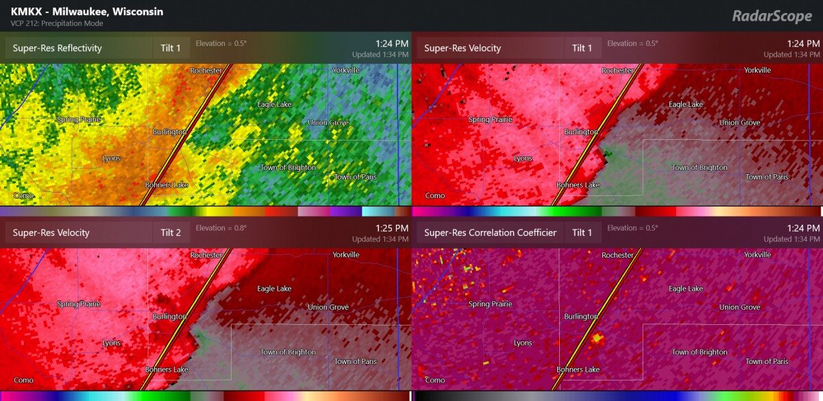
This velocity bulge was a reported tornado at Frankville, next to Racine. When I was 5 years old, my parents rented a place outside of Racine. And that's where and when I actually survived a -30 degree temperature by staying inside.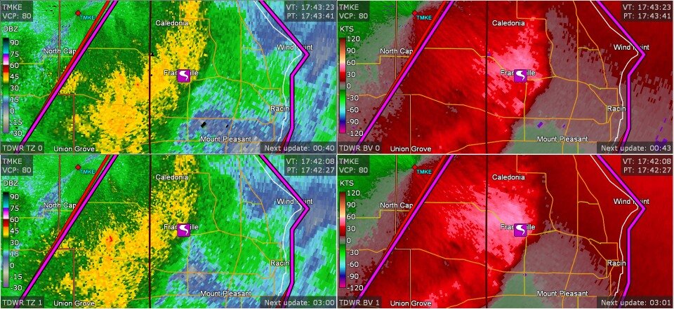
-
2022 Short/Medium Range Severe Weather Discussion
Chinook replied to Chicago Storm's topic in Lakes/Ohio Valley
reported tornadoes reported tornado near Burlington Wisconsin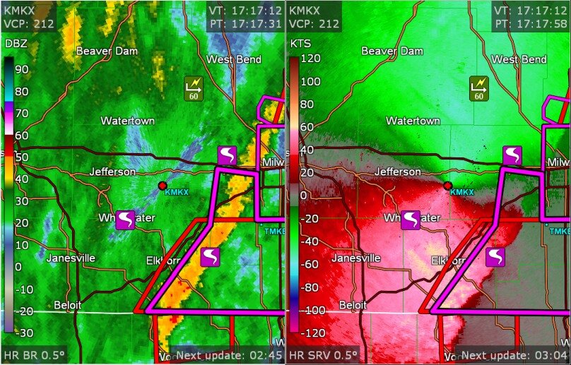

-
2022 Short/Medium Range Severe Weather Discussion
Chinook replied to Chicago Storm's topic in Lakes/Ohio Valley
Confirmed tornado warning North Prairie, WI -
Julia | 85 mph 982 mb peak | EPAC Crossover #2
Chinook replied to Iceresistance's topic in Tropical Headquarters
Potential Tropical Cyclone 13 - Here is the first section of Discussion #1 -
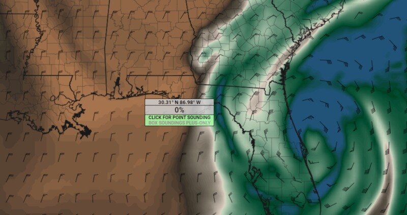
there could be blue skies west of the tropical storm
-
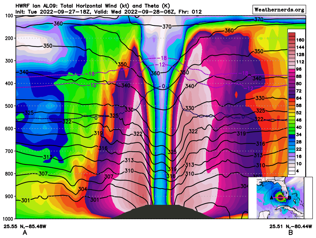
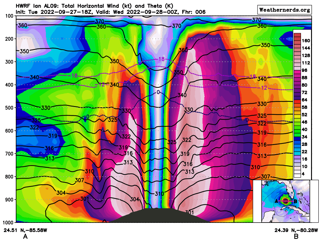
The wind speeds are the bright colors, regardless of wind direction. in this case, it is a slice from west to east across the hurricane, so west is to the left. The 64 knot winds (hurricane force) are purple and higher, and the 96 knot winds (category 3) are light pink and other pink colors. The isotherms (0 degree C, -12 degree C, -18 degree C) are the small dashed lines that bump up in the middle of the storm. Hurricanes concentrates the warmer air at the eye, due to the latent heat release at the eyewall. The solid black lines are a little confusing as it represents potential temperature. When they dip down, then it is warmer. The 96 knots to maybe 115 knots on the east side of the eye reach very high into the air, about 35000 feet. Winds weaken at 40000 feet. The west side of the storm has some slightly different qualities in terms of how the winds change with height. The gray bump is due to the fact that the sea level pressure is around 950 mb, which is much different than the typical 1000mb. The highest winds are above the surface, but certainly winds of up to 120 knots are not far from the surface. This is a 12 hour forecast from the HWRF, for 06z

-
Buoy 42026 with 63mph gusting to 85mph wind (time: 0135z)
-
latest storm cross-section

-
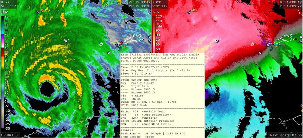
first gust of 46 knots at Key West