Chinook
-
Posts
10,933 -
Joined
-
Last visited
Content Type
Profiles
Blogs
Forums
American Weather
Media Demo
Store
Gallery
Everything posted by Chinook
-
Here is a picture of the sunset before the fireworks. There was not really much rain going on in the whole area at this time. I saw a couple of distant flashes of lightning while I was trying to watch fireworks.
-

2022 Short/Medium Range Severe Weather Discussion
Chinook replied to Chicago Storm's topic in Lakes/Ohio Valley
this large storm has already produced 90mph wind gusts at 16:26z -
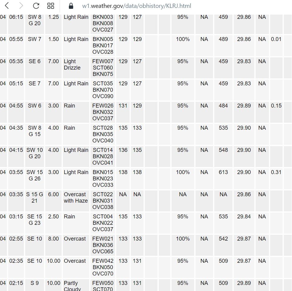
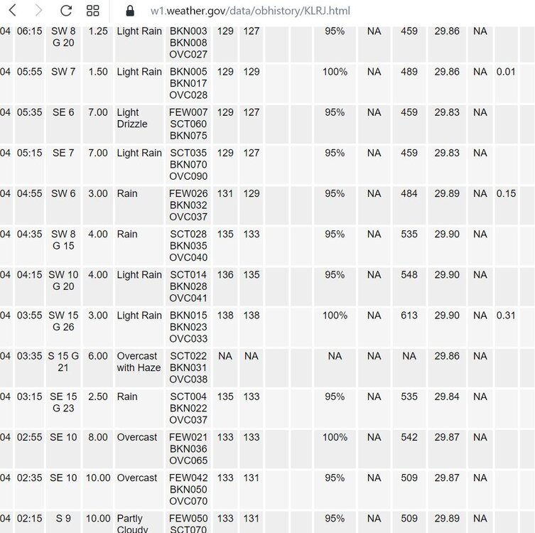
There's a soupy 84 degree dew point at Denison Iowa right now. I think it's tied for the highest (USA) dew point I've seen on a weather map, ever. Le Mars Iowa says dew point of 91 but I honestly believe this is an error. In fact, Le Mars 99/91 would result in a heat index of 149.9 if it were true. Le Mars has had a really screwed up weather sensor with temp of 138, dew of 138, H.I. of 613.
-
2022 Short/Medium Range Severe Weather Discussion
Chinook replied to Chicago Storm's topic in Lakes/Ohio Valley
I noticed that close to midnight for me (1:00AM central time) and I was pretty surprised this was not associated with a notable individual cell. There must be some damage around US-34 on the edge of the city of Grand Island, and perhaps tracked northeastward for over 1 mile. I usually look at the Day-1 outlook issued at 06z (midnight for me) so I was looking at radar. -
Precip yesterday
-
the Southwestern states, partially covered with thick clouds and rain today two views of this month's precipitation
-
apparently my area got some rain at midnight to 2:00AM without thunder The northeast Texas panhandle went from 100 degrees to 58 degrees in under 24 hours with this cold front and is still just at 61 degrees this afternoon. (station: HHF)
-
I wonder what's the hottest possible Stanley Cup combination of cities, including one city from the Western Conference and one city from the Eastern Conference. On average, Stanley Cup final games occur on about June 1st-7th, unlike this year. It is difficult to keep the ice in perfect condition at this time of the year with outside temperatures of 80 or 90 with higher humidity in many areas outside of the desert. Maybe the hottest combination could be Phoenix and Miami. Then, Las Vegas and Tampa are also quite similar. Dallas is a possibility, but I think that Las Vegas and Phoenix average hotter high temperatures on June 7th. When Dallas played Tampa, it was the end of September 2020, so that is certainly not time of the year with the greatest temperature.
-
tonight's sunset
-
completely clear last night
-
Coldest June 21st in New Mexico?
-
some long-awaited monsoon rainfall for New Mexico and Arizona, as well as SW Colorado
-
It was Cameron Pass. I walked 100 yards in various directions. I couldn't really hike due to the fact that it was pretty much a swamp with 1 ft deep snow drifts. There is water running down the mountainside in random directions. I couldn't find the snowshoeing trail, but there was a sign that said the Cameron Connection trail was closed. There are some trees that have been cut down and stacked next to the parking lot due to an avalanche. The Cameron Peak fire didn't burn the pass. The area west of Rustic has completely burnt mountainsides. I also noticed trees down next to the Crags campground. Now, you can see plenty of evidence of both the High Park fire and the Cameron Peak fire if you drive the canyon.
-
Here's a rare extremely clear day for the Midwest. I noticed that some of the crops seem to be quite light-colored today. Here is the black/white visible and also colorized visible. I wonder if the corn is showing a lot of light-colored tassels in a bunch of areas. I have also always wondered why eastern Arkansas has a light color on visible imagery at almost all times. I guess the other possibility is that Ohio is a desert today-- lots of sand! Wow, there's really not sandy soil. I just made that up.
-
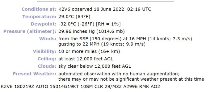
This eastern Colorado airport (Yuma) has a moisture sensor that has been bad for a couple of days at least. That's a little weather comedy for you. My place never got to the 90's yesterday with clouds. The dew point did drop after the storm over the mountain ended, but it never got sunny enough to get Fort Collins or Loveland to 90 degrees. Some areas west of Albuquerque had 1" of rain yesterday with the monsoon surge.
-
tomorrow: the NWS has issued a somewhat rare heat advisory for us. The moisture from tonight should mix out and we will have dew points in the 30's again while the temperature increases to 98-99 degrees.
-
lightning a new storm developed to the west of a storm that dropped large hail at Platteville near sunset
-
supercell near Ajax/Scarborough, with possible 1" hail
-
some severe weather warnings in Canada
-
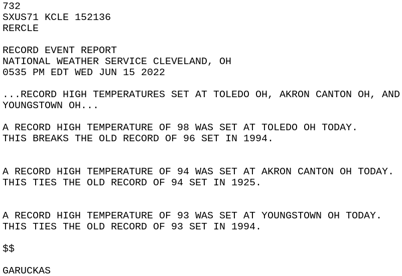
Record highs -- RECORD EVENT REPORT NATIONAL WEATHER SERVICE WILMINGTON OH 452 PM EDT TUE JUN 14 2022 ..RECORD HIGH TEMPERATURE SET AT DAYTON OH A RECORD HIGH TEMPERATURE OF 95 WAS SET AT DAYTON OH TODAY. THIS BREAKS THE OLD RECORD OF 94 SET IN 1895 --
-
If you like sports...
-
2022 Short/Medium Range Severe Weather Discussion
Chinook replied to Chicago Storm's topic in Lakes/Ohio Valley
2-d slice into the vertical for this large radar-detected wind of 80kt-90kt -
Late night tornado warning in an Iowa, not too far from Council Bluffs and Omaha
-
The cold front is coming through, now. We have had a few days of mid to upper 90's. There are much cooler temps in Utah/Wyoming at this hour. Today, the upper level winds moved some wildfire smoke from central Arizona up here and it was hazy, perhaps visibility 20 miles to the mountains. I went to the mountain pass, and obviously not enough haze to inhibit seeing nearby mountains. I felt some cool wind gusts and walked on some snow drifts. I saw several areas of burnt trees from the fire in the upper Poudre Canyon in 2020. It's nice to know that there are many trees and structures near the road that were not burnt. I am guessing a lot of the forest beyond this trailhead has burnt trees
-
There's a very broad but noticeable rotation with severe storm at the IN/MI border near Angola. This storm brought 75mph wind gusts to Sturgis MI recently.