Chinook
-
Posts
10,933 -
Joined
-
Last visited
Content Type
Profiles
Blogs
Forums
American Weather
Media Demo
Store
Gallery
Everything posted by Chinook
-

Central/Southern Plains Severe Weather Palooza (4/29 - 05/05)
Chinook replied to Powerball's topic in Central/Western States
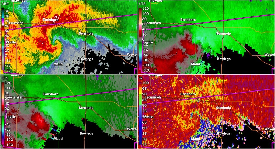
new tornado warning a long way southeast of Oklahoma City. confirmed tornado at 7:54 central time mentioned in the warning. edit: debris field was 1 mile wide at an area a couple of miles west southwest of Seminole.
-
Central/Southern Plains Severe Weather Palooza (4/29 - 05/05)
Chinook replied to Powerball's topic in Central/Western States
There are two non-confirmed tornado warnings near Tulsa. I think the southern storm has broad rotation that may be evolving into a higher coverage of wind or possibly a higher coverage of hail in the metro. There is some possibility of a new tornado developing out of it. -
Central/Southern Plains Severe Weather Palooza (4/29 - 05/05)
Chinook replied to Powerball's topic in Central/Western States
new tornado warning with maybe a couple areas of rotation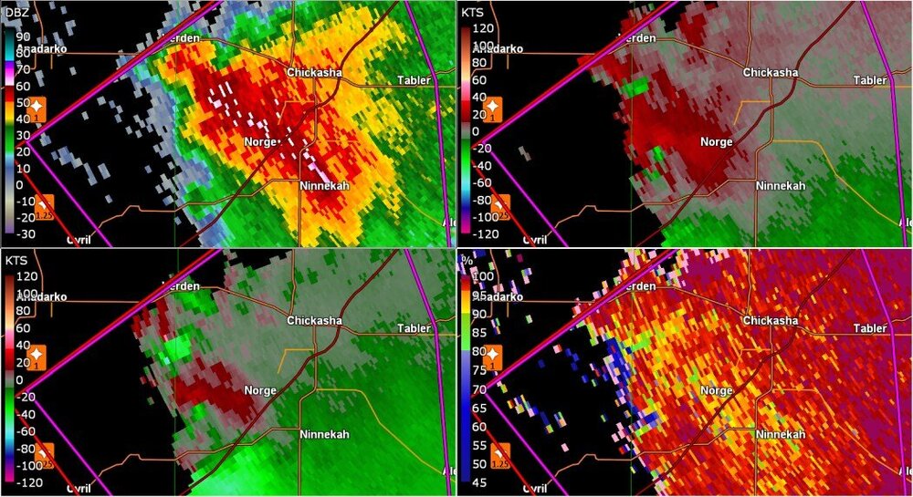
-
Central/Southern Plains Severe Weather Palooza (4/29 - 05/05)
Chinook replied to Powerball's topic in Central/Western States
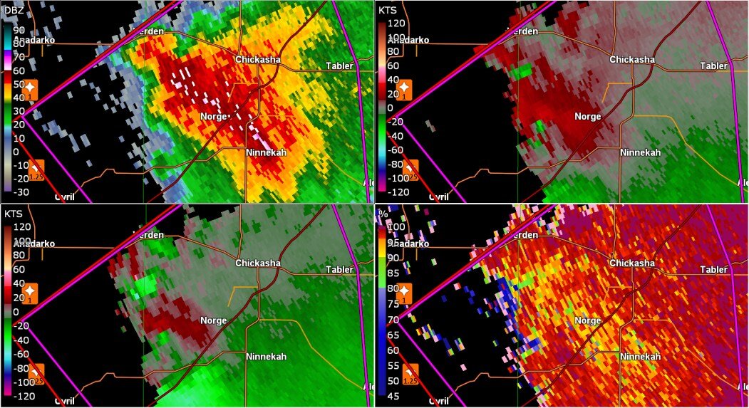
that was a roughly 1 mile wide CC drop for the debris, so, obviously pretty notable damage and debris in the air. -
Central/Southern Plains Severe Weather Palooza (4/29 - 05/05)
Chinook replied to Powerball's topic in Central/Western States
Enid, max wind of 55 kt from the northwest with rain. wind must have shifted from the southeast. Just think if you had to walk to your car. -
Central/Southern Plains Severe Weather Palooza (4/29 - 05/05)
Chinook replied to Powerball's topic in Central/Western States
I think the rear flank winds kind of busted out there and started up the spin next to Enid. -
Central/Southern Plains Severe Weather Palooza (4/29 - 05/05)
Chinook replied to Powerball's topic in Central/Western States
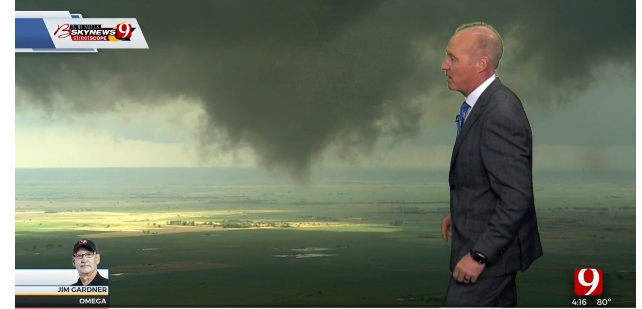
I haven't had a whole lot of reasons to watch the Oklahoma City TV stations since May 2013, when of course the helicopter crew caught the developing Moore tornado. And I think there was something on the May 30th or 31st in that same year. -
Central/Southern Plains Severe Weather Palooza (4/29 - 05/05)
Chinook replied to Powerball's topic in Central/Western States
the helicopter crew caught another brief tornado on the ground at 4:26, but then it was kind of gone -
Central/Southern Plains Severe Weather Palooza (4/29 - 05/05)
Chinook replied to Powerball's topic in Central/Western States
yeah, watonga, Loyal, real brief tornado, as they said on the air at maybe 4:15 central time
-
Central/Southern Plains Severe Weather Palooza (4/29 - 05/05)
Chinook replied to Powerball's topic in Central/Western States
helicopter view of tornado from Oklahoma City - News 9 -
Central/Southern Plains Severe Weather Palooza (4/29 - 05/05)
Chinook replied to Powerball's topic in Central/Western States
maybe distinguishable funnel cloud near Watonga -
Central/Southern Plains Severe Weather Palooza (4/29 - 05/05)
Chinook replied to Powerball's topic in Central/Western States
Storms by Alva seem to all being showing the curvature such that they might be supercells. I would suppose they could compete quite a bit. Still kind of awesome to see every single storm looking like a kidney bean. I would think one or more storms will produce a tornado in that group. -
Central/Southern Plains Severe Weather Palooza (4/29 - 05/05)
Chinook replied to Powerball's topic in Central/Western States
It should be a surface-based updraft. Perhaps a brief moment when I believed the CC (correlation) looked low, as if a debris signature. But I don't know if the debris signature ever happened, or I suppose, nobody ever reported a tornado. -
Central/Southern Plains Severe Weather Palooza (4/29 - 05/05)
Chinook replied to Powerball's topic in Central/Western States
already looking a lot like a possible tornado producer near Bucklin, Kansas (radar from 1959z)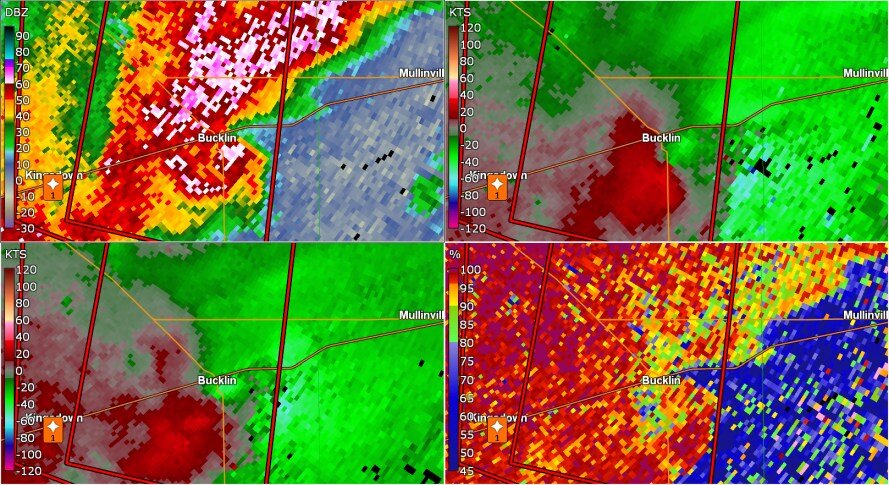
-
My area had 0.11" rain in April and 0.30" rain last night. The grass has been quite dry. I don't think many lawns can run their sprinklers, because they probably activate sprinklers after the chance of frost is gone. We've got 85% humidity today. That's something. edit: western Nebraska really does have accumulating snow today, so, kind of a rude awakening for May, but it should help with the drought, with maybe some 0.5" water equivalent going to help the crops as soon as it melts.
-
Central/Southern Plains Severe Weather Palooza (4/29 - 05/05)
Chinook replied to Powerball's topic in Central/Western States
3-d view of tornado warned storm at Andrews a few minutes ago two updrafts -
Central/Southern Plains Severe Weather Palooza (4/29 - 05/05)
Chinook replied to Powerball's topic in Central/Western States
WRF-NSSL really has a large cluster of storms, stretching some 150-200 miles along I-20. I wonder if this is possible. -
Central/Southern Plains Severe Weather Palooza (4/29 - 05/05)
Chinook replied to Powerball's topic in Central/Western States
I'd say there is a strong case for a tornado outbreak in Oklahoma, as long as they can hit the 70's after the morning storms. -
Central/Southern Plains Severe Weather Palooza (4/29 - 05/05)
Chinook replied to Powerball's topic in Central/Western States
Convection-allowing models showing numerous storms from SE Colorado down into New Mexico, Texas, and Mexico. Each model shows the storms heading eastward, rather than stalling. This particular model has has a storm near Wichita Falls. The overall scenario looks very good, with mid-50's dew points, 0-6km shear of about 50 kt, and, as mentioned in the long SPC discussion, increasing storm relative helicity. By the way, the people of the region might freak out if they see a raindrop, let alone heavy rain or a tornado. Last rain over 0.01" at Tucumcari, NM was March 31st. -
2022 Short/Medium Range Severe Weather Discussion
Chinook replied to Chicago Storm's topic in Lakes/Ohio Valley
Near Bloomington, Illinois -
2022 Short/Medium Range Severe Weather Discussion
Chinook replied to Chicago Storm's topic in Lakes/Ohio Valley
confirmed tornado warning at I-294 and Westchester, Elmhurst -
2022 Short/Medium Range Severe Weather Discussion
Chinook replied to Chicago Storm's topic in Lakes/Ohio Valley
Update: the 06z outlook has slight risk with the typical 5% tornado outlook, for primarily Illinois, but also over to Indianapolis and southeast Missouri and nearby Arkansas. -
2022 Short/Medium Range Severe Weather Discussion
Chinook replied to Chicago Storm's topic in Lakes/Ohio Valley
Convection-allowing models show some somewhat-discrete storms going directly into Chicago tomorrow. I'm decently impressed by the 0-6km shear and 0-3km storm-relative helicity in the area of several of these cells. -
Central/Southern Plains Severe Weather Palooza (4/29 - 05/05)
Chinook replied to Powerball's topic in Central/Western States
current tornado-warned storm at Minden, NE (no confirmed tornado that I know of) -
2022 Short/Medium Range Severe Weather Discussion
Chinook replied to Chicago Storm's topic in Lakes/Ohio Valley
The 00z convection-allowing models have high coverage of thunderstorms near the Illinois-Indiana border on Saturday afternoon. There are some disagreements on shear, possibly varying from 30 kt to 50 kt. Storm-relative helicity will not be too high. CAPE values could be 1500 - 2000 J/kg.