

Chinook
-
Posts
10,934 -
Joined
-
Last visited
Content Type
Profiles
Blogs
Forums
American Weather
Media Demo
Store
Gallery
Everything posted by Chinook
-
It has been a snowy time for me, and a bunch of the country, but not far west.
-
Here are my long loops of the radar for this storm and the GFS surface/precip images. It took me 83 hours of saving radar images for this. Of course, did use the archive feature, but I really did take 4 days of occasional saving of data. http://www.greatlakes.salsite.com/Feb_1_to_4_2022_radar_loop1.html http://www.greatlakes.salsite.com/Feb_1_to_4_2022_GFS_surface_loop1.html
-
I think I really got 8.5" to 8.7" and 0.58" of water equivalent. These are the last 2 runs of the NOHRSC analysis.
-
radar and precip type from every station
-
My place got a bunch of high-ratio fluff, by my estimation, we went from 2.0" at 8:30PM to 7.7" at 11:00PM. Then, I think the snow packed down and we got a much lower snowfall rate. Storm reports 7-11" for Loveland, 7-12" Fort Collins, somewhere around 8" at my place.
-
radar and all METAR precip types
-
first accumulation on pavement: 4:00PM or perhaps a little later 8:30PM, 2" on ground or more, snow rate 0.5"-1" per hour, winds 15mph plus, away from town. Probably 5-10mph in town.
-
Loveland stayed above 50 degrees for a few hours while some cooler air moved in through every other area. The cold air from central Canada is blasting into the Dakotas tonight with 40mph to 55mph wind gusts. NWS Boulder has made some small adjustments: 6-8" Fort Collins, Greeley, Boulder, Evergreen, Colorado Springs, 4-6" Estes Park, Denver Castle Rock, 3-4" Denver Airport, approximately 4"- most of the plains of Colorado. The 00z GFS and Canadian still have pretty high QPF values with 0.6" to 0.9" for west of I-25, which is effectively higher than the NWS expects. And the joke of the day award goes to the ... NAM, with zero snow for me.
-
pretty cool to be able to make images of frontogenesis for a major event like this
-
My place is now getting the downslope winds before the storm. It wasn't windy an hour ago, or really, not windy for a few days. Here is what NWS Boulder posted before. This storm is going to hit my homeland of northwest Ohio pretty bad, I think.
-
Denver will probably issue a winter storm watch or winter weather advisory. It seems like they would already have done something like that with the "weather story" graphic from their web page.
-
my radar loop of the storm (ending this morning) http://www.greatlakes.salsite.com/Jan_28_30_2022_radar_loop.html
-
Models are back up to QPF of 0.3" to 0.7" for west of I-25. I believe that it will snow over 3" for my place, perhaps much more, as snow ratios could be above 12:1 or 13:1. I just hope it starts after I get home from work on Tuesday. That would be nice. I'm not sure were Mayjawintastawm used to live, but this may generate some interest. (Magenta color is 30dBz). Wind gusts have been even 60mph to 70mph at Cape Cod.
-
Talking about Groundhog's Day, how about 2/2/2011. This was the Midwest's Groundhog's Day Storm, which was part of a bigger system that brought some of the coldest air I've seen in Fort Collins, with a -19F outside Fort Collins and -17F at Denver Airport, -38F at Laramie. Our localized Groundhog's day storm 2/2/2012 (I think a significant portion of the snow fell on 2/3/2012) Then, there was our other Groundhog Storm, 2016. That was the one where I saw the 500mb trough on the GEFS ensembles something like 12 or 13 days in advance.
-
Models generally have more than 0.3" of QPF for Tuesday, with some variations in timing.
-
My area probably got 1" today, possibly a bit more. Storm reports say 1.5" Fort Collins and Loveland, 2"-3" from Longmont down to Denver, possibly 2-4" south Denver
-
Looks like GFS/Canadian tonight still have a strongly cooling temperatures and snow for Tuesday (2/1) (as discussed before)
-
Nothing in reality looks exactly like the GFS 180 hour forecast. Nevertheless, we've certainly had times when you've been sort of right. It seems like we have broken out of the very long dry period. It seems like this sort of upper level trough is supported by ensembles.
-
Snow reports from Denver are 4" to 5", similar to my area. The snow award goes to some rural area outside of Goodland, with apparently some awesome dynamics
-
The heavier snow is at Denver right now with 1/2 mile visibility at DEN, Erie, BKF (1/4 mile) APA (1/4 mile) As for me, the storm is done. I am pretty sure I got 4".
-
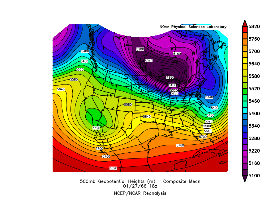
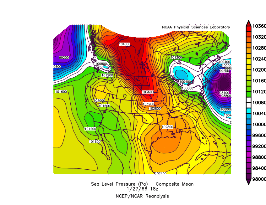
Several significant weather features came together for a large storm in the Mid-Atlantic area on January 30, 1966. This was a strong phasing situation, that is, a combination of troughs at 500mb. The western lobe of the polar vortex was over the Great Lakes and then dropped in to the Mid-Atlantic, combining with a southern disturbance, which looks like a smaller bump in the 500mb plot. The southern disturbance carried most of the moisture northward. The large divergence at the jet stream level helped to intensify the surface low coming up from the Gulf of Mexico. The low pressure went east of Washington DC and moved northward to Vermont at about 975 mb. On one of the maps posted below, you can see that a combination of multiple events gave over 30" to central Virginia and Maryland within Jan. 20th- Feb 2nd. Lake effect snow under the polar vortex went nuts later in the storm and gave Oswego NY, 60" to 100" a lot coming on January 31st-February 1st. January 30th official NWS Analysis http://greatlakes.salsite.com/maps/jan2931_1966_500_loop.gif http://greatlakes.salsite.com/maps/jan2931_1966_sfc_loop.gif http://greatlakes.salsite.com/Phasing/1960s/Jan_29_1966/500mb_speed_loop.html http://greatlakes.salsite.com/maps/jan2931_1966_850_loop.gif
-
Hey Mid-Atlantic friends. I found this new model output giving probabilities of precipitation for the GFS Ensembles. Right now, some of the Mid-Atlantic has a 40% chance of 1" of snow and eastern Massachusetts has a 70% chance of 1" of snow. (later model hour than this.) I guess we'll see if this type of ensemble output is helpful in the next 2 days. After that, certainly the operational models will be most helpful.
-
Models generally have snow for eastern Colorado on Monday night-Tuesday with a 500mb shortwave from the northwest
-
My area got some freezing drizzle and maybe 0.5" snow or better.
-
We have a new winter weather advisory for freezing drizzle tonight/tomorrow. I didn't really see that one coming.


