Chinook
-
Posts
10,964 -
Joined
-
Last visited
Content Type
Profiles
Blogs
Forums
American Weather
Media Demo
Store
Gallery
Everything posted by Chinook
-
Yesterday's long-range GFS came up with a fantasy storm for mid-Lake Erie to Windsor ONT. Today, fantasy for CLE-BUF.
-
NWS point&click and MEX-MOS has 4 out the next 5 mornings at or below 0 for Toledo area. The average low for these days is 23!
-
Toledo is just 0.7" away from tying the record snowiest February. (25.2" and 25.1" are the top 2, separated by 111 years)
-
A few wind gusts in northwest Ohio have reached 48-49mph. It must be very annoying and dangerous, for the people out there who might be more likely to get frostbite.
-
Toledo had a light glaze tonight, then some sleet, then some snow. Unknown Precipitation "UP" in the ASOS reports is frequently sleet (although I have no idea why) KTDZ 090016Z AUTO 03010G17KT 3SM FZRA BR OVC005 00/M02 A2981 RMK AO2 UPB12E13FZRAB13 P0000 I1001 T00001017 TSNO KTDZ 090353Z AUTO 03011G18KT 3SM -SN BR OVC009 M02/M04 A2989 RMK AO2 SNB26 CIG 006V013 SLP125 P0001 T10221044 TSNO TOL KTOL 090352Z 04010KT 8SM FEW007 OVC016 M02/M03 A2988 RMK AO2 UPE02B49E51FZRAB02E13SNB13E49 SLP124 P0003 T10221033
-
Toledo area storm totals. CoCoRAHS shows 11-14" in the Toledo area, 9-12.5" in Henry County Ohio, 15.3" in Monroe County MI, 8" in Sandusky County OH. Edit: 12" of snow at Toledo Express. NWS public information statements/LSRS Michigan
-
My brother just asked me what they will get in Canton. Wow. Hard call. I think some rain will happen in the middle of the storm, if any rain.
-
I see freezing rain/sleet at CAK and freezing rain at AKR, and spotter reports of freezing rain from Canton/Akron to Pittsburgh.
-
A few radar images of OH/IN from yesterday/last night
-
Well, PCW airport ASOS has reported some slightly weird things since it came online (less than a year ago?). Maybe that -14 temperature wasn't one of the weird ones. I don't remember this ASOS being there before 2014. http://www.portclintonairport.com/
-
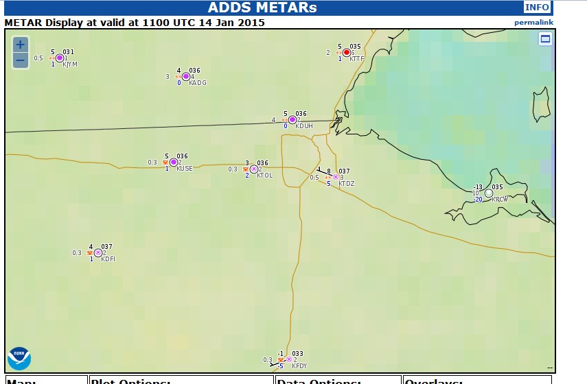
It was an unusual morning with various levels of radiational cooling around Toledo. At 11z, Toledo ranged from 3 to 8 degrees, it was -1 at Findlay, and Port Clinton (PCW) had a low of -14. Toledo (TOL) reached its low of -2 around midnight, and warmed to 3 by sunrise. Does anyone know if Port Clinton (PCW) is experiencing problems with the ASOS device? This is a very low temperature considering it must be close to the lake. image
-
What do you guys think for the LES potential on Jan. 7th? I see 850 and 700mb temps pretty darn cold. 700mb temps down to -34C over the lake, with a 30kt NW wind from the surface to 700mb. I wonder if snow bands will organize to make for a big snow event for NE Ohio. On the other hand, I wonder if this is -too- cold and dry. Then again "too dry" seems a little dumb seeing as how the RH values aren't too bad on the GFS.
-
I'm dreaming of a power outage for Christmas, just like the ones I used to know.
-
High wind watch for northern Ohio.
-
As for northern Ohio discussion: my call is for a 50% chance for a wind gust over 50 kts (58mph) at KTOL on Christmas Eve- very early Christmas Day.
-

Central/Western Medium-Long Range Discussion
Chinook replied to andyhb's topic in Central/Western States
5-10 inch rain amounts have affected the Pac NW. This weekend another 1-3" should affect the Pacific coast ranges. Apparently, the Hurricane Ana remnants will affect the Pac NW on Monday. I'm glad to see the Pacific coast get some rain. Not much for California though. Halloween-November 2nd seems to be cool and dry east of the Mississippi. That's over 168 hours though. It really doesn't seem too weird, perhaps just the first temps below 32 degrees for northern areas.
-
Central/Western Medium-Long Range Discussion
Chinook replied to andyhb's topic in Central/Western States
I was at the Ohio Severe Weather Conference a few years back. I saw Harold Brooks talk about climatological CAPE and shear. I believe Brooks said that the fall severe weather season is partly ruined by bad lapse rates from the Mexican Monsoon. Weak lapse rates are typically advected in from Mexico, they are much closer to moist adiabatic than the EML of springtime. -
Central/Western Medium-Long Range Discussion
Chinook replied to andyhb's topic in Central/Western States
The NAM is advertising some 5-10 EHI values for Iowa, Minnesota, and Missouri tomorrow. That's pretty high for September! -
Alaska/Western Canada obs and discussion
Chinook replied to patrick7032's topic in Central/Western States
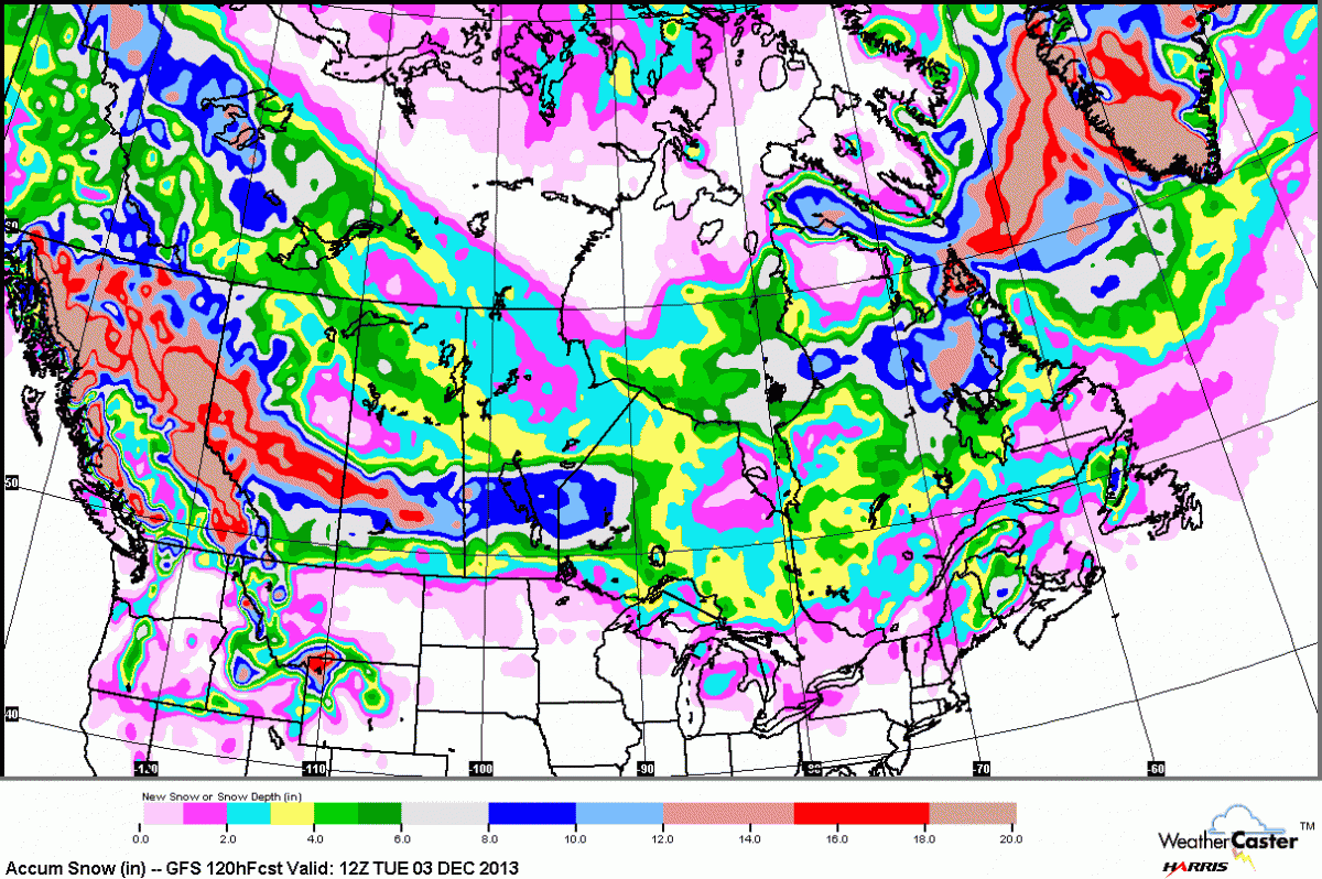
heavy snow for Canadian Prairies shown in 3-5 days on the recent runs of the GFS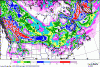
-
Alaska/Western Canada obs and discussion
Chinook replied to patrick7032's topic in Central/Western States
-38F and -32F at Fairbanks Ft Wainwright (-38F) PAFB 211855Z 00000KT 6SM BR FEW008 M39/ A3014 RMK PWR PLNT PLUME FEW008 Fairbanks Airport (-32F) PAFA 210753Z 00000KT 7SM CLR M36/ A3031 RMK AO2 SLP287 T1356 PNO -
Alaska/Western Canada obs and discussion
Chinook replied to patrick7032's topic in Central/Western States
This is kind of old news now. Fairbanks got to 92 degrees, only 4 degrees below its highest June temperature ever (96) on June 25 and 26 2013. The highest all time temp is 99, so that's still several degrees above the 92 of this year. ------------ FairbanksYears: 1904-2013RANK 4 92 6/26/2013, 6/25/2013, 6/22/1987, 6/20/1958, 6/25/1916 ----------- Nome AK tied its highest all time temperature on June 19 2013 ---------- NomeYears: 1906-2013Rank Value Ending Date 1 86 6/19/2013, 7/31/1977, 7/8/1968 ----- McGrath AK, also highest temperature ever ------- Mcgrath Area (ThreadEx Station)ExtremesHighest Daily Maximum Temperature (degrees F)Days: 1/1 - 12/31Length of period: 1 dayYears: 1941-2013Rank Value Ending Date 1 94 6/17/2013 2 91 6/18/2013 3 90 6/16/2013, 6/15/1969 -
Alaska/Western Canada obs and discussion
Chinook replied to patrick7032's topic in Central/Western States
Mayo Yukon, -47C CYMA 011900Z 00000KT 20SM VCFG SKC M47/ A2994 RMK VIS W SLP245 -
Bowling Green Ohio- book by county weather historian. "Back in the extremely cold winter of 1918, a severe blizzard commenced.... snow drifts ten feet high and dropped the temperature to 18 degrees below zero." Bowling green went from +24 to -18 that day. I can't exactly say what the wind chill was at any hour. It might have been 0F with a wind of 30mph, resulting in a wind chill of -25.9F. That's probably conservative.
-
Alaska/Western Canada obs and discussion
Chinook replied to patrick7032's topic in Central/Western States
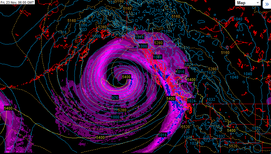
nice pacific low
-
Alaska/Western Canada obs and discussion
Chinook replied to patrick7032's topic in Central/Western States
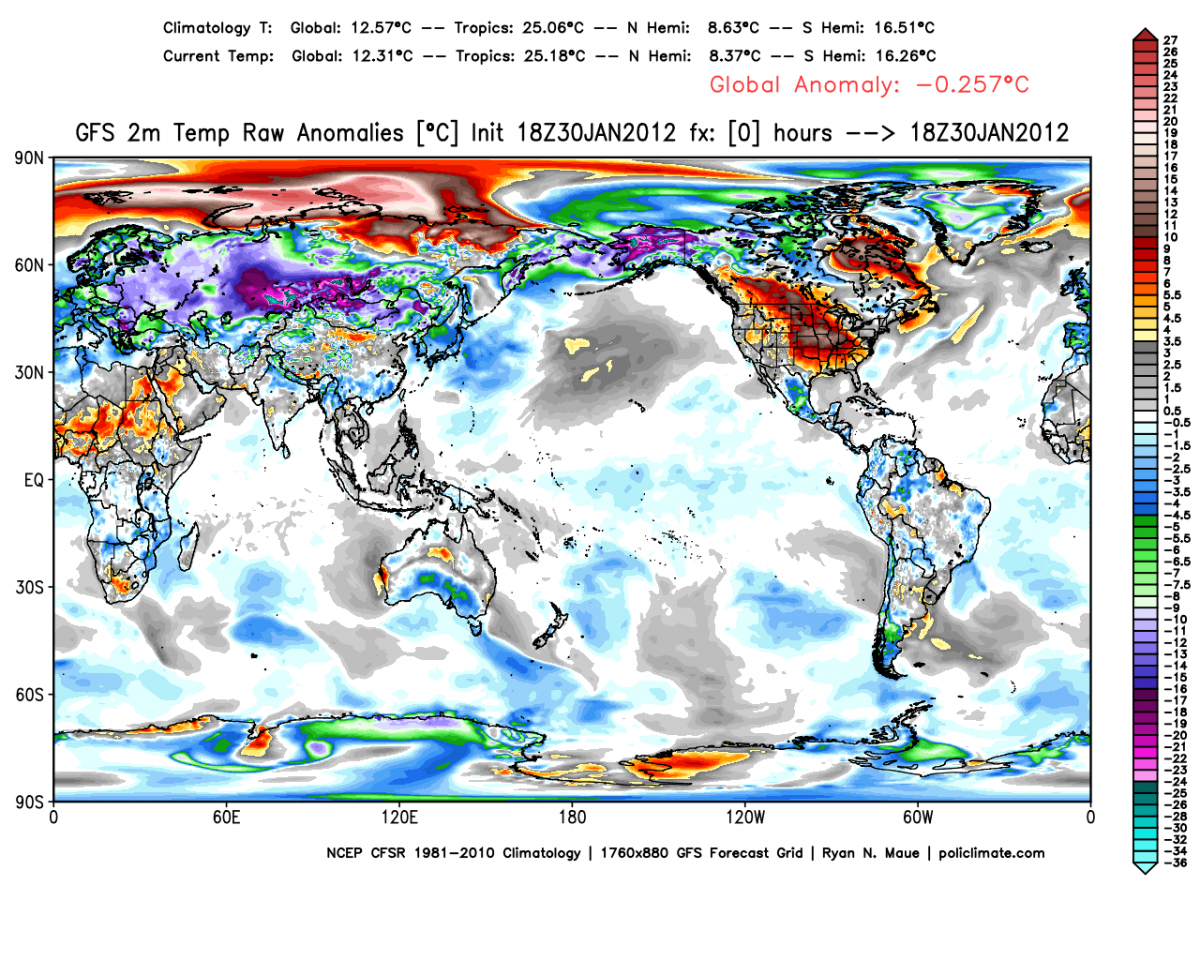
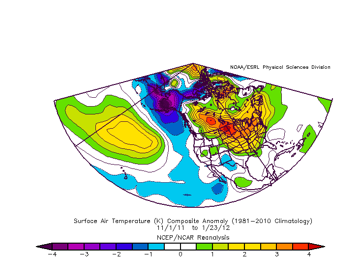
Part of Siberia and Alaska more than 32 C below normal. That's the turquoise colors. That's 58 F below normal. source for this plot: http://policlimate.com/weather/current/raw_temp_c.html November 1st to January 23rd temperature anomalies on NCEP reanalysis. Wow. cold times in Alaska. Quite the La Nina surprise in western Canada and North Dakota.