high risk
-
Posts
2,916 -
Joined
-
Last visited
Content Type
Profiles
Blogs
Forums
American Weather
Media Demo
Store
Gallery
Everything posted by high risk
-
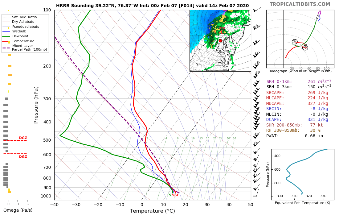
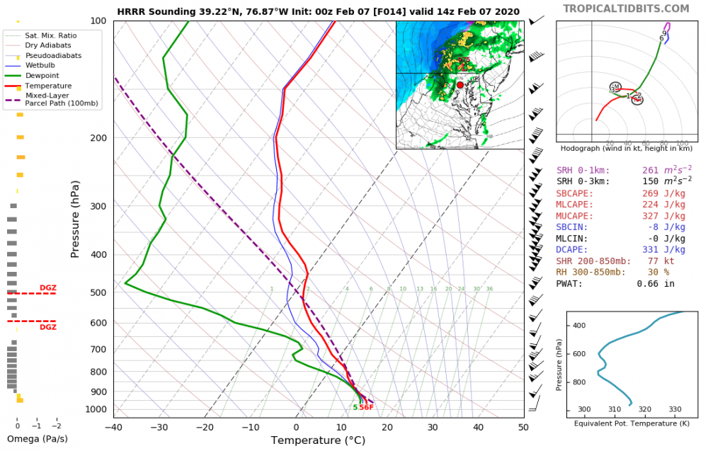
Some folks are thinking about snow showers in northern MD tomorrow, and that is on the table, but I'm more interested in the "warm sector" along the I-95 corridor tomorrow morning ahead of the occluded front. A lot of guidance briefly puts this area into the low-mid 50's, and there should be a band of convection along the front. Some of the CAMs develop a little bit of instability, and it's really cold aloft with decent lapse rates, so while I'm not ready to call for thunder, I'm wondering if some places might get a burst of graupel or small hail.
-
10:1 NAM maps have some "accumulation" for some of the metro area Wednesday evening. That's because the model microphysics have a mix of rain and sleet - definitely supported by the soundings which have a decent layer below freezing above temps around 34 at the sfc. Definitely could see some pingers around during those initial hours of rain early Wednesday evening before the column warms.
-
So yeah, the sfc temps look a tad high along the i-95 corridor, but even if it's 34, that's a wet snow sounding with such a shallow layer of "warmth" at the ground. Add in the fact that the GFS has been running warm at the sfc in recent winter events here and the fact that it's at night, and I'll be very happy with what will be falling if we can get some decent precip.
-
FWIW, the 18z GFS trended way better with the weekend shortwave. Edit: LOL. Looked nice at 132 but then got flattened 6h later.....
-

Mid January/Mid February Medium/Long Range Discussion
high risk replied to WinterWxLuvr's topic in Mid Atlantic
While obviously acknowledging that it's not worth parsing details 84 hours out, that NAM solution verbatim at 12z Thursday has surface temps a few degrees below freezing in the local area, and even though the sfc high is shifting east across New England, surface winds in the mid-Atlantic are progged weak and from the northeast, suggesting a damming scenario that could persist well into Thursday. -
roads are ok here in southern Howard County, but there is a pretty glaze on the trees.
-
This is a legit concern. Most of the 00z hi-res guidance increases the lull time.
-
This is a good catch, but the idea of that initial band having some sleet in it is an outlier solution, and the associated forecast soundings have a warm layer that is just barely above freezing. Something to watch for in the evening runs, though.
-
because the snow falling tomorrow morning will fall at temperatures in the 20s which always causes problems
-
Fantastic agreement among the hi-res models for the initial band of snow at some point during the 7-10am or so time frame (earlier for those further west) followed by a break for a few hours before the main batch of precip arrives with snow changing to sleet to (maybe a period of freezing rain) to rain through the mid/late afternoon hours (with the temps taking extra time to crack the freezing mark north of I-70). I still believe that the morning snow band is going to cause a lot of road problems with the temps in the 20s.
-
It's worth noting that there is really good agreement that there will be a band of snow pushing across the area during the morning tomorrow. It's narrow, and it won't last long (and it's not clear how far south it will extend), and accumulations won't be great. BUT, it will fall with temps in the mid 20s, so it will likely cause some travel troubles. It's also clear that we then get a break before the primary precip band arrives from the west. How much we can warm before it arrives will of course determine the impacts from that.
-
No doubts at all about the shear. NAM nest showed a strongly forced line of convection moving through very early Sunday. As Yoda notes, instability is pretty meager, but temps will be rising through the 60s Saturday night, so being able to mix down some momentum to the sfc isn't a total fantasy.
- 2,802 replies
-
- 1
-

-
- severe
- thunderstorms
- (and 4 more)
-
Getting stickage now in southern Howard County. Impressive rates.
-
Later tonight???? This event is over by 8pm at the latest.
-
Cwg calling for 65 5 days from now I think it's legit and may actually end up too low. Most guidance shows 850 temps approaching +15 here. Saturday and Saturday night are likely toasty, and Sunday could be too if the GFS solution is too fast.
-
Ah, so it's a Kuchera-derived product. And I missed that you were referring to areas well west of DC Metro. Thanks!
-
I'll bite. Where are you getting that the NAM ratios are 11-12:1???
-
I like what I've seen from the Kuchera plots. I'll admit that it drives me nuts when it's going to be an all sleet or a white rain event, and people post the 10:1 maps screaming "The GFS/NAM/whatever is predicting 14" here. LOL." The models are NOT doing that. Any sleet or snow gets tallied together into a liquid amount, and then the web sites slap on a generic ratio that makes a product with already severe limitations 5x worse.
-
I'd respectfully argue that it's way better than 10:1 maps in any sort of sleet or mixed events or in a daytime event with lousy rates or super warm ground. It fails in the events with it knows that that the temps are marginal and cuts amounts that can stick, but in the real world the rates overcome the marginal temps.
-
Nope. Still going strong....
-
This isn't true. It absolutely still is an operational system.
-
NAM actually takes most of the area up to 40 tomorrow ahead of the precip (low to mid 40s in southern MD) but has strong cooling as the precip arrives to bring most areas down into the lower 30s.
-
It's always worth remembering in these marginal events that the 10:1 maps do NOT represent what the model thinks will be on the ground. There is a total snowfall liquid equivalent parameter that reflects how much liquid is falling as snow out of the model. It makes no attempt to answer what the SLR will be or whether it will stick; those maps are TT throwing a 10:1 ratio on that liquid total. The accumulated snow depth plots DO reflect what the model thinks will actually accumulate on the ground.
-
THIS. We've had many instances over the years with temperature well below freezing leading up to an event, and even a small amount of snow turns the roads into a disaster. Tonight's event will feature temps well above freezing slowly falling to maybe around freezing. Any place that gets under a significant band could certainly see some slick spots, but it's hard to imagine a scenario with widespread travel problems (until you get further north and northwest from the 95 corridor).
-
Guidance had been pretty consistent on weakening this snow band and confining the remnants to northern MD, but the 00z NAM and the Hi-Res Windows now bring a dusting all the way south to Montgomery/Howard Counties (and some even into northern part of DC/PG County). Hoping to wake up to a coating here in southern Howard.