CAPE
-
Posts
36,289 -
Joined
-
Last visited
Content Type
Profiles
Blogs
Forums
American Weather
Media Demo
Store
Gallery
Everything posted by CAPE
-

2023 Mid-Atlantic Garden, Lawn, and Other Green Stuff Thread
CAPE replied to mattie g's topic in Mid Atlantic
It's time to start the incremental reseeding/overseeding process. More grass has survived than usual, so it won't be a near complete do over. Normally clover takes over as the grass withers away, but it has not done so this year. The key might be getting 10" of rain in July lol. Normal rainfall never made a difference. -
58 at dawn.
-
Well its 6am- still dark lol. Got used to being in the higher latitudes. Winter is coming.
-
After 2 weeks away was thinking of doing a bit of mowing (as nice as it feels out now), but a couple drinks in + weed, eff that. With the mixing/lowering dews, should be prime mowing weather around 6am- about 60 f.
-
75/56 Drier air working in here.
-
^With the once again/as usual/seen this before depleted CB group (at least in the short term), the front end of the D will need to do some good work.
-
Seems like a good signing. Needed a vet and he is much younger than the remaining options like Houston.
-
2022 BCBS for HH. Just a bit different than the HH stouts I was drinking the last couple weeks
-
Had a brief shower overnight, enough to wet the ground.
-
Incredible. Been to Yellowstone. Glacier is at the top of my list.
-
The weekend looks pretty damn nice, esp the early part. We shall see what happens next week, but for now on the GEFS, it looks like a brief spike in heat and humidity Mon/Tues, followed by seasonable temps/relatively comfy dewpoints mid to late week as the C US upper ridge retrogrades westward with lower h5 heights arriving from the N/NE under a building NAO ridge. Appears to be a rather dry period regardless.
-
Man, get me back to the UK. This shit sucks. Doesn't snow so much there(lol and?), but easy to grab a flight from there to Iceland and the Scandinavian countries, etc. I could live there, for lots of reasons, some of which are OT.
-
Back home and back to reality now. Nice break from warm and humid. It appears 2.3" of rain fell here for the first half of August.
-
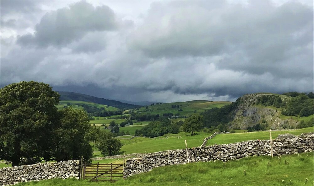
A proper British Sunday roast dinner at noon with a pint of Guinness, and a photo from Yorkshire Dales. I'll post a few more later.
- 225 replies
-
- 14
-

-
It's still ongoing. Yesterday was "hot" here. Around 80. Heading to Yorkshire Dales tomorrow, but the weather looks more showery.
-
Without even looking I'm sure snowmannumbs has parroted that tweet in the main thread to support his 'opinion'.
-
Enjoy it while it lasts. Can't keep winning if the young talented players smartly drafted and developed in the minors end up Yankees and Dodgers in a few years. They won't pay. Worst ownership in sports now that Snyder was finally booted.
-
2023 Mid-Atlantic Severe Wx Thread (General Discussion)
CAPE replied to Kmlwx's topic in Mid Atlantic
I'll be monitoring my security cam from here beginning around midnight. Hoping not to see tree debris flying all over the place.- 2,785 replies
-
- 2
-
-
- severe
- thunderstorms
- (and 3 more)
-
It's whatever. He adds nothing of substance and has a clear agenda. Not sure why a member who is deemed a useless turd in another sub is able to be a nuisance here though.
-
The daily post limited member from another sub forum is still pissed that no one cares what he thinks lol.
-
who cares about a daily post limited member's opinion? anyone?
-
53 currently. Nice sunset after a damp day. Just took a long walk and back at dusk, around 930. Probably won't experience anything like this at home until maybe early Nov.
-
CPC/NCEP continues to favor a moderate to strong event. Plenty of opinions in the twittersphere and elsewhere. Some are hyperbolic and baseless, driven by an agenda.
-
With all the travel yesterday, I didn't really have a chance keep on top of the trade deadline moves. Nice pick up for the Os, but that's it? I kind of agree with this take. The Baltimore Orioles and Cincinnati Reds are cowards It’s all right there for two division leaders far too worried about tomorrow https://deadspin.com/mlb-trade-deadline-orioles-reds-verlander-no-hitter-1850699165