All Activity
- Past hour
-

July 2025 Obs/Disco ... possible historic month for heat
powderfreak replied to Typhoon Tip's topic in New England
Low of 70F… +15. BTV hasn’t been below 77F tonight. That’s a tough night if you don’t have A/C. Nocturnal storms and clouds, and away from the cooler maritime air mass up this way.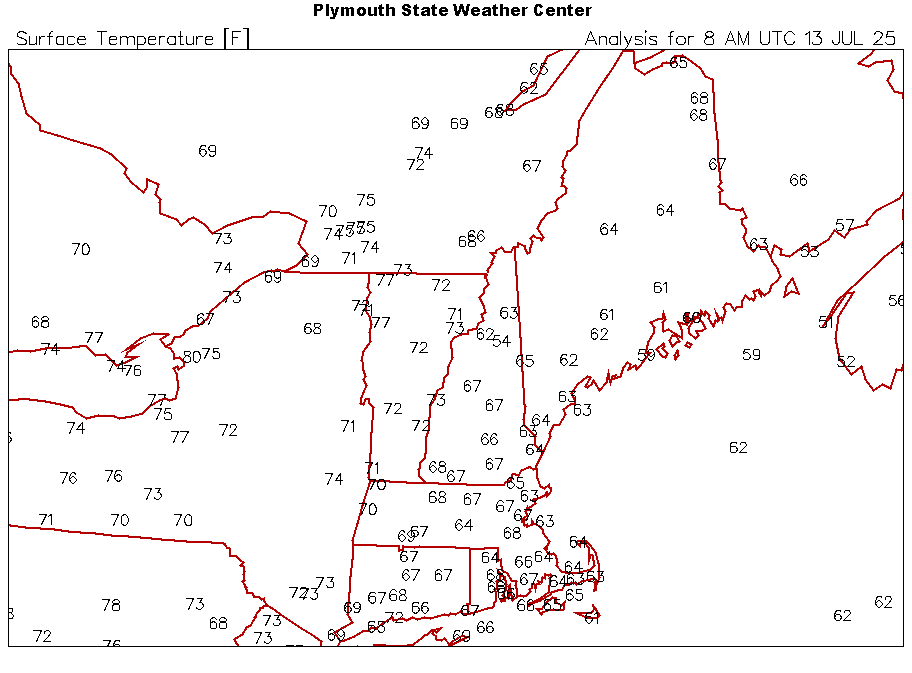
-

Gulf AOI Watch: The Season’s Not Sleeping Yet! (0/20)
tiger_deF replied to BarryStantonGBP's topic in Tropical Headquarters
I’m expecting the models to back on and off of development of this feature, especially given the background state, but this ICON run is an eye opener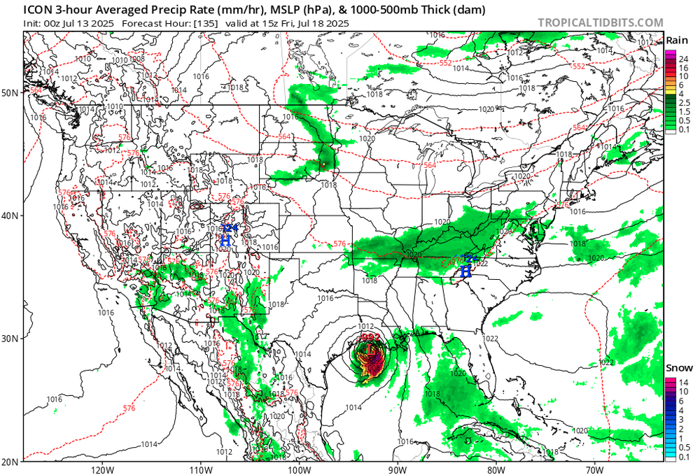
- Today
-

July 2025 Discussion-OBS - seasonable summer variability
JerseyWx replied to wdrag's topic in New York City Metro
Our summers have always been hazy, hot and humid. That's just typical Jersey and New York climate. Yes I know that it has gotten worse, with dewpoints averaging higher than they used to, but it's not like we were ever arid like the high desert out west. -
another day of dews 75-80F. Just unreal.
-
July 2025 Obs/Disco ... possible historic month for heat
powderfreak replied to Typhoon Tip's topic in New England
You can toss overnight lows all you want, but it’s why everyone in the SNE hills, NNE, mtns, ME coast is installing A/C these days compared to 10-15 years ago. I get why folks often want to toss those temps once you’ve given into artificial cooling and are tucked soundly in bed next to the hum of a cooling source… but there’s been a “real feel” effect and you see it with every mini split or AC install that wasn’t there a decade ago. People used to get through summer with windows open at night. The warm mins have had a real societal impact. -
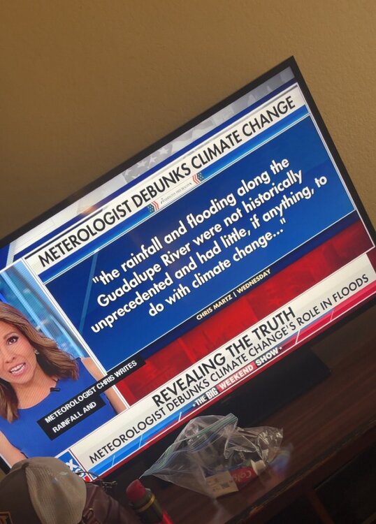
Hey Chesco, Maybe so. That was a disaster waiting to happen even without CC. We’ll never know for sure about the possible influence of CC on this terrible incident as well as on many other specific incidents. But CC/GW has meant ~ a 7% increase in moisture held in the air per degree C increase. So, CC does make these incidents of very heavy rains within a fairly short period more frequent overall worldwide than before. Tropical systems, themselves, have on average gotten slightly wetter. Another thing CC has apparently caused is a slight slowdown of average steering winds due to a lowered contrast of the temperature gradient between the tropics and Arctic. Thus, the slightly slower avg movement of slightly wetter tropical systems means more frequent extreme rainfall events from tropical systems.
-

July 2025 Obs/Disco ... possible historic month for heat
WxWatcher007 replied to Typhoon Tip's topic in New England
Really hadn’t thought about that. Runaway warmth… -

July 2025 Discussion-OBS - seasonable summer variability
FPizz replied to wdrag's topic in New York City Metro
Happens in plenty places outside the park, who cares except for the homeless that sleep there? -

2025-2026 ENSO
Stormchaserchuck1 replied to 40/70 Benchmark's topic in Weather Forecasting and Discussion
It's because it's not overpowering other forces. If we had an El Nino at +5c, there would no doubt be a trough in the North Pacific. -

July 2025 Obs/Disco ... possible historic month for heat
dendrite replied to Typhoon Tip's topic in New England
Yup…ice slows warming. It sucks up a lot of heat trying to phase change. Keep losing all of that year to year up there (permafrost, glaciers, sea ice) and all of thermal energy goes into warming instead of melting. Our Canadian source region gets hotter and warmer earlier and now it’s practically cut off for weeks or over a month at a time in the heart of summer. Just some impotent fronts that give us dew downs or ooze in from the NE via a BD. -

E PA/NJ/DE Summer 2025 Obs/Discussion
JTA66 replied to Hurricane Agnes's topic in Philadelphia Region
Looked like the Great Pumpkin rising in the east. -

July 2025 Obs/Disco ... possible historic month for heat
weatherwiz replied to Typhoon Tip's topic in New England
Our cold fronts are essentially dewpoint fronts lol -

2025 Atlantic Hurricane Season
BarryStantonGBP replied to BarryStantonGBP's topic in Tropical Headquarters
I could see that happening -

July 2025 Obs/Disco ... possible historic month for heat
CoastalWx replied to Typhoon Tip's topic in New England
Your comment a few years back stuck with me. We melted all the permafrost up there and we simply have cold fronts of bore vs yore. -
So great to see young professional Meteorologists getting time on major networks to help start to turn the tide on the old climate alarmist fake narratives on simple cyclical weather events!!
-
July 2025 Obs/Disco ... possible historic month for heat
dendrite replied to Typhoon Tip's topic in New England
ORH was 83° today…+3F. Yesterday was 81° (+1F). Like Scoot said…we need mank to go BN this time of year. It takes a miracle to do it with a cP airmass out of Canada now. -
July 2025 Obs/Disco ... possible historic month for heat
weatherwiz replied to Typhoon Tip's topic in New England
Well that explains the difference! Elevation and coastline will 99.9% of the time be cooler. Think of lapse rates. If you have higher elevations (say above 1000’) like ORH pushing 90 or into the lower 90’s…then you’re talking about some extreme heat region wide. For the most part days/nights have been above average. If 925/850 temperatures are above average and well above the the entire region is above…maybe some locations are a bit less but that is more reflective of local climate versus large scale pattern and the large scale pattern holds more weight -
I guess this was a failed attempt at a bit of humor...
-

E PA/NJ/DE Summer 2025 Obs/Discussion
ChescoWx replied to Hurricane Agnes's topic in Philadelphia Region
Nice moon shot over the ocean in Sea Isle City NJ this evening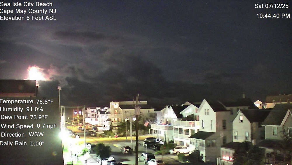
-

July 2025 Obs/Disco ... possible historic month for heat
ineedsnow replied to Typhoon Tip's topic in New England
1,068 -
July 2025 Obs/Disco ... possible historic month for heat
ineedsnow replied to Typhoon Tip's topic in New England
meh last few days haven't been maybe just above today -
July 2025 Obs/Disco ... possible historic month for heat
weatherwiz replied to Typhoon Tip's topic in New England
What’s your elevation? -
July 2025 Obs/Disco ... possible historic month for heat
dendrite replied to Typhoon Tip's topic in New England
lol if everyone around you is AN then you are too. Your avg high is just lower. What are we even doing? -
July 2025 Obs/Disco ... possible historic month for heat
ineedsnow replied to Typhoon Tip's topic in New England
81.3 for a high here is upper 80s got it -
July 2025 Obs/Disco ... possible historic month for heat
weatherwiz replied to Typhoon Tip's topic in New England
Climate change is definitely roaring its head. I mean the last few days down here have been equivalent to probably some of the hottest days we’ve had this summer. The only difference is the super high sun angle…that sun is strong and you can get burned within minutes. But outside right now…it doesn’t feel much different than the warm nights up there


