All Activity
- Past hour
-
0z Euro looked much better for early May
-
Love the pick hate the cost
-
So so early
-
Sweep up that garbage team into the trash as far as I’m concerned.
-
Big average high temperature spread between the LI and CT Shorelines and NJ since March 1st. AEROFLEX-ANDOVER AIRPORT WBAN 65.4 ESTELL MANOR COOP 63.9 PENNSAUKEN 1N COOP 63.3 MILLVILLE MUNICIPAL AIRPORT WBAN 63.0 SALEM COOP 62.8 SOUTH JERSEY REGIONAL AIRPORT WBAN 62.8 MOORESTOWN 4 E COOP 62.4 MCGUIRE AFB WBAN 62.4 PHILADELPHIA/MT. HOLLY WFO COOP 62.1 Atlantic City Area ThreadEx 61.8 OCEAN COUNTY AIRPORT WBAN 61.8 ATLANTIC CITY INTL AP WBAN 61.8 SOMERSET AIRPORT WBAN 61.7 New Brunswick Area ThreadEx 61.5 Data for March 1, 2026 through April 24, 2026 Average High temperature Click column heading to sort ascending, click again to sort descending. NJ CALDWELL ESSEX COUNTY AP WBAN 61.2 NJ NEWARK LIBERTY INTL AP WBAN 60.7 NJ TETERBORO AIRPORT WBAN 60.5 NY PORT AUTH DOWNTN MANHATTAN WALL ST HEL ICAO 60.3 NJ TETERBORO AIRPORT COOP 60.1 NJ HARRISON COOP 59.5 NY NY CITY CENTRAL PARK WBAN 59.4 NY LAGUARDIA AIRPORT WBAN 58.3 NY MONTGOMERY ORANGE COUNTY AP WBAN 58.3 CT DANBURY MUNICIPAL AP WBAN 57.8 NY SHRUB OAK COOP 57.6 NJ CHARLOTTEBURG RESERVOIR COOP 57.3 CT DANBURY COOP 56.8 NY WESTCHESTER CO AP WBAN 56.7 NY RIVERHEAD RESEARCH FARM COOP 56.5 NY STEWART FIELD WBAN 56.4 CT MERIDEN MARKHAM MUNICIPAL AP WBAN 56.3 NY PORT JERVIS COOP 56.2 CT NORWICH PUBLIC UTILITY PLANT COOP 55.8 NY JFK INTERNATIONAL AIRPORT WBAN 55.5 NY BAITING HOLLOW COOP 55.5 NJ CANOE BROOK COOP 55.2 NY FARMINGDALE REPUBLIC AP WBAN 55.0 NY SYOSSET COOP 55.0 NY ST. JAMES COOP 54.8 NY ISLIP-LI MACARTHUR AP WBAN 54.3 CT OXFORD WATERBURY WBAN 54.2 CT IGOR I SIKORSKY MEMORIAL AIRPORT WBAN 53.8 NY CENTERPORT COOP 53.8 NY CARMEL 4N COOP 53.4 CT GUILFORD COOP 53.4 NY UPTON COOP - NWSFO NEW YORK COOP 53.2 CT NEW HAVEN TWEED AP WBAN 53.1 NY SHIRLEY BROOKHAVEN AIRPORT WBAN 52.3 NY ORIENT POINT STATE PARK COOP 52.1 CT GROTON NEW LONDON AP WBAN 51.3 NY WESTHAMPTON GABRESKI AP WBAN 50.7 NY BRIDGEHAMPTON COOP 50.3 NY MONTAUK AIRPORT WBAN 48.9
-
Wheel of rhea
-
No idea but i was figuring it would be truly horrendous with the cold shelf water after this winter, but to me at least it hasn't been all that bad. Next 10 days might change that opinion!
-
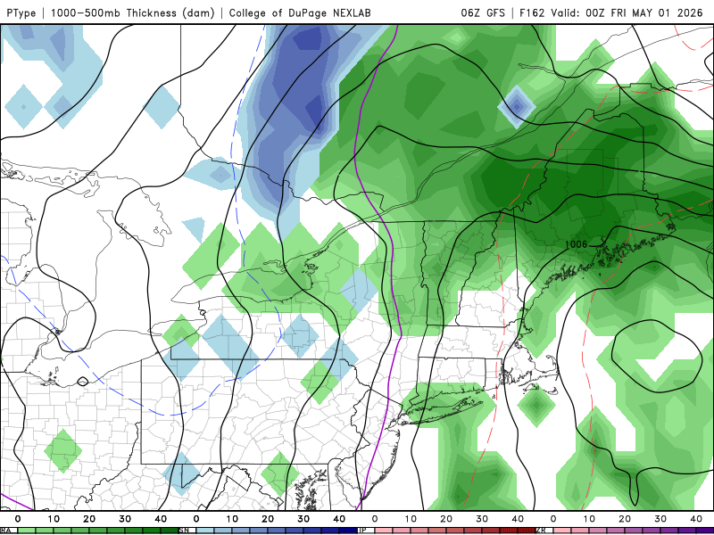
What a way to start May
-
This year seems to have been a bigger and deeper bite
-
I don’t have the data to support, but it seems to be very cloudy most days. Very few sunny days
-
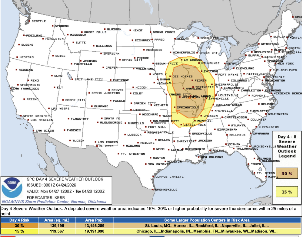
Large D4 30% contour for much of IL and parts of WI, IN, IA, MO, AR, TN and KY. Mention of strong tornadoes but not as strong of wording as I'd expect. Regardless, shaping up to be another all hazards possible event especially if things can remain more supercellular. ...DISCUSSION... Latest medium-range model output suggests that a significant short wave perturbation emerging from the Southwest will pivot northeast of the middle/lower Missouri Valley, into the upper Great Lakes region, Monday through Monday night. It appears that the warm sector of an associated sub-1000 mb surface cyclone will become characterized by at least moderately large CAPE, ahead of the dryline/cold front overspreading much of the middle Mississippi Valley during the afternoon into evening. In the presence of strong deep-layer shear, organized severe thunderstorm activity appears probable. It remains a bit unclear the extent to which sustained supercell development will be maintained, as opposed to convection quickly growing upscale into one or more clusters/lines, but there appears at least some potential for a few strong tornadoes, in addition to large hail and potentially widespread strong to severe wind gusts.
-

2026-2027 El Nino
snowman19 replied to Stormchaserchuck1's topic in Weather Forecasting and Discussion
Yet the very strong WWBs, DWKW’s, TC’s and very impressive, rapid subsurface and surface (especially in region 1+2) warming continues unabated -
I have Sirius but also FM AM and Spotify. I listen to Boomer and Gio in the morning on my way to work and listen to Yankee games on 660 AM. Brooms are out
-

2026-2027 El Nino
SnoSki14 replied to Stormchaserchuck1's topic in Weather Forecasting and Discussion
The comparison doesn't make sense because waters are so much warmer overall now vs 97. You have to consider the anomalies compared to currents sst norms. -
I don’t think it will be that dire.
-
I'd be lying if I said I knew a thing about Makai Lemon. It sucks we had to trade with the Cowboys, but the Cowboys are dumb asses, so hopefully Howie fleeced them! Crowded receivers room, sounds like SOMEONE has to go.
-
I knew the warm March and 90s in mid April would come back to bite us.
-

Central PA Spring 2026 Discussion/Obs Thread
NepaJames8602 replied to Voyager's topic in Upstate New York/Pennsylvania
Snow is back in the grids here in the Poconos Sat night LOL. Saturday Night Rain and snow showers before 4am, then a chance of snow showers. Low around 33. East wind around 10 mph, with gusts as high as 21 mph. Chance of precipitation is 80%. Little or no snow accumulation expected. Sunday A chance of snow showers before 7am, then a chance of rain and snow showers between 7am and 8am, then a chance of rain showers after 8am. Partly sunny, with a high near 51. Northeast wind around 10 mph, with gusts as high as 20 mph. Chance of precipitation is 30%. -
The SOI has dropped back down to -11. It may drop further temporarily. However, the models are not suggesting a further sustained drop to the 3 day long -30ish level of April 9-11 in the immediate future. So far, the SOI hasn’t been overly impressively negative for an oncoming very strong Nino vs history.
-
Hopefully it can get to the areas in upstate NY where the reservoirs are located.
-
I feel like we've done ok here. Alot of sunny days which I'm fine with even if it's cold.
-
According to my weather app, today is the last sunny day for a week and a half
-
I might take a ride to monticello casino, i'm hearing they may get a few inches of snow tomorrow! Gamble a little blackjack and get some snow best day
-
Can’t remember the last time I turned on a radio, in the car or elsewhere. Min of 24F.
-
Even if the KW were to verify as strongest in history (however long the recorded history of KWs is), why the “Very very massive yikes”? That wording implies to me that that’s worrisome. Why would that be something to get worried about? Are we in trouble? To me this is just more of his being over the top and not professional.
.thumb.gif.f92b16c631a1d15d405ed77b33f0710d.gif)


