All Activity
- Past hour
-

2025-2026 ENSO
40/70 Benchmark replied to 40/70 Benchmark's topic in Weather Forecasting and Discussion
Yes, that part of his post doesn't make much sense. I have no idea why the west warm pool is all of a sudden going to become prohibitive to +TNH...it never has been. He also says we will need a SSW to avoid an early end to winter....probably true, but if you look at the east-leaning cool ENSO/strong easterly QBO/high solar data set, it would be very surprising if we didn't one. -

White Christmas Miracle? December 23-24th
CPcantmeasuresnow replied to Baroclinic Zone's topic in New England
Whiteout conditions. Awesome. -

White Christmas Miracle? December 23-24th
SouthCoastMA replied to Baroclinic Zone's topic in New England
Hail Mary here would be to get 1" via the sagging inverted trough on Christmas Eve. -

Possible Light Snowfall (1" - 4") on Tuesday Dec 23
sussexcountyobs replied to Northof78's topic in New York City Metro
Will Central Park measure .1" of snow? They'll probably clock in with .08". -

Possible Light Snowfall (1" - 4") on Tuesday Dec 23
MJO812 replied to Northof78's topic in New York City Metro
Gfs.thumb.png.634bb9545e9618817c5df3d3ed938596.png)
-
2025-2026 ENSO
40/70 Benchmark replied to 40/70 Benchmark's topic in Weather Forecasting and Discussion
This is exatly why I am saying that you don't use them to forecast.....consider them as either confirmation or a a voice of dissent. IDC what the weeklies do, or how much they waffle.....my money has been on a pretty strong PV throughout a good portion of January since last fall. -
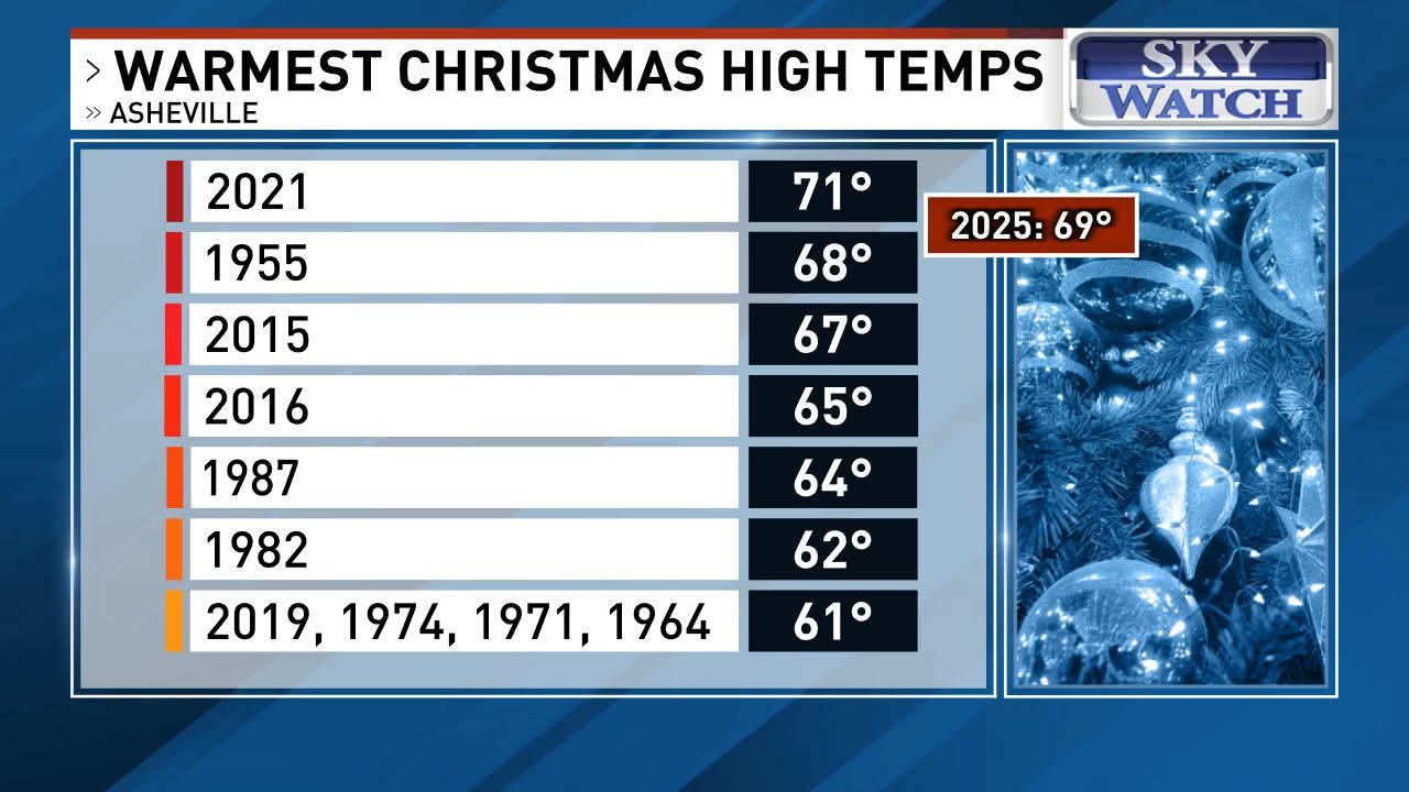
4 of the top 5 record highs on Christmas in Asheville are in the past 10 years.....

-

White Christmas Miracle? December 23-24th
bristolri_wx replied to Baroclinic Zone's topic in New England
You don’t even really need a map for the forecast: Coating to an inch: S/E I-95 1-3”: N/W of I-95 to I-90 2-4” I-90 N to NH/VT/ME Mountains 3-5”+ NNE mountains Probably won’t be model agreement until tomorrow, as again northern stream energy is windshield wipered on the models every time a reindeer farts in the wind. It might snow near Christmas. Expect disappointment and be pleasantly surprised if it does. Happy holidays! -
Gfs
-
FFC is forecasting 4 days of 70s highs in ATL: 12/24-7 with 12/28 in the mid 60s. As has been said, the 4 days of 70+ in late Dec would be pretty historic although not as high as a few years that had 5-6 days of 70+ in late Dec.
-

E PA/NJ/DE Winter 2025-26 Obs/Discussion
RedSky replied to LVblizzard's topic in Philadelphia Region
.30" snow in Allentown with that juggernaut -

RONI vs. ONI
so_whats_happening replied to so_whats_happening's topic in Weather Forecasting and Discussion
I do not have an issue with the idea of what RONI is to show, which is the impact we have seen from a warming world in response of increases with CO2 and others. My issue is say we get to a point where there is such a difference that is large enough to become an error in a way. An example would be if ONI reads -.5 but RONI reads it as moderate event so < -1 creating a difference of nearly 0.5 or more do we believe the RONI value to be more representative of the atmosphere or do we believe ONI has a better handle? I guess this is the million dollar question of course. I mean they even mention it towards the end themselvesThe cyclical aspect will be interesting to follow coming up here, AMO seems to be throwing some curveballs right now I would have liked to have seen just how much difference does continue to show and maybe was used more in conjunction with seeing differences and the impact on atmospheric events in comparison to ONI values. BOM must know something more than we do in now using RONI versus ONI values. @donsutherland1 -
Possible Light Snowfall (1" - 4") on Tuesday Dec 23
MJO812 replied to Northof78's topic in New York City Metro
Temps will be similiar as the last event for NYC with less precip. No Temps in NYC will be in the low 30s. -
Very windy, gusting into the 40s to near 50
-

White Christmas Miracle? December 23-24th
WinterWolf replied to Baroclinic Zone's topic in New England
True. -
December 2025 regional war/obs/disco thread
WinterWolf replied to Torch Tiger's topic in New England
Lol right…Cuz it’s stupid. -
White Christmas Miracle? December 23-24th
bristolri_wx replied to Baroclinic Zone's topic in New England
Not sure how we have epic meltdown’s in a 1-3” region wide event. -
December 2025 regional war/obs/disco thread
WinterWolf replied to Torch Tiger's topic in New England
Wouldn’t that be rain for Jerry on that depiction? -

Possible Light Snowfall (1" - 4") on Tuesday Dec 23
NEG NAO replied to Northof78's topic in New York City Metro
even in NYC immediate metro ? whats it going to be well inland ? -
So be it then. I’d be fine with that.
-

Possible Light Snowfall (1" - 4") on Tuesday Dec 23
Northof78 replied to Northof78's topic in New York City Metro
The snow will not be wet, temps in mid to upper 20s for most of accumulating snow time -
Possible Light Snowfall (1" - 4") on Tuesday Dec 23
sussexcountyobs replied to Northof78's topic in New York City Metro
Yup. I posted that hours ago. This may be a very nice little snow event. -

December 2025 regional war/obs/disco thread
Damage In Tolland replied to Torch Tiger's topic in New England
There’s Jerry’s icer -
.thumb.png.4150b06c63a21f61052e47a612bf1818.png)
December 2025 regional war/obs/disco thread
HIPPYVALLEY replied to Torch Tiger's topic in New England
I was just thinking about how fun it would be to have no power after Christmas. -
Why is South Dakota highlighted?
.png.0f0170e77debf3d686699eee8449f29e.png)