All Activity
- Past hour
-
I want to say that was around the time the city started to experience it's development boom (well before the 70's) but would be a reasoning to explain the rapid increase in overnight mins (urban heating)...very similar to that of Las Vegas
-
75” of snow that started in mid-November. Constant LES. Tundra-like feel at times. No ice storms. A well-timed torch in February with thunderstorms before more snow. Solid A. Would be A+ if we had one more good synoptic event.
-
Compacted now like the ol squeezebox
-
Yup, meh. But it could end up giving us a better shot at the SWFE the more it fades
-
Yardstick jamming notwithstanding
-
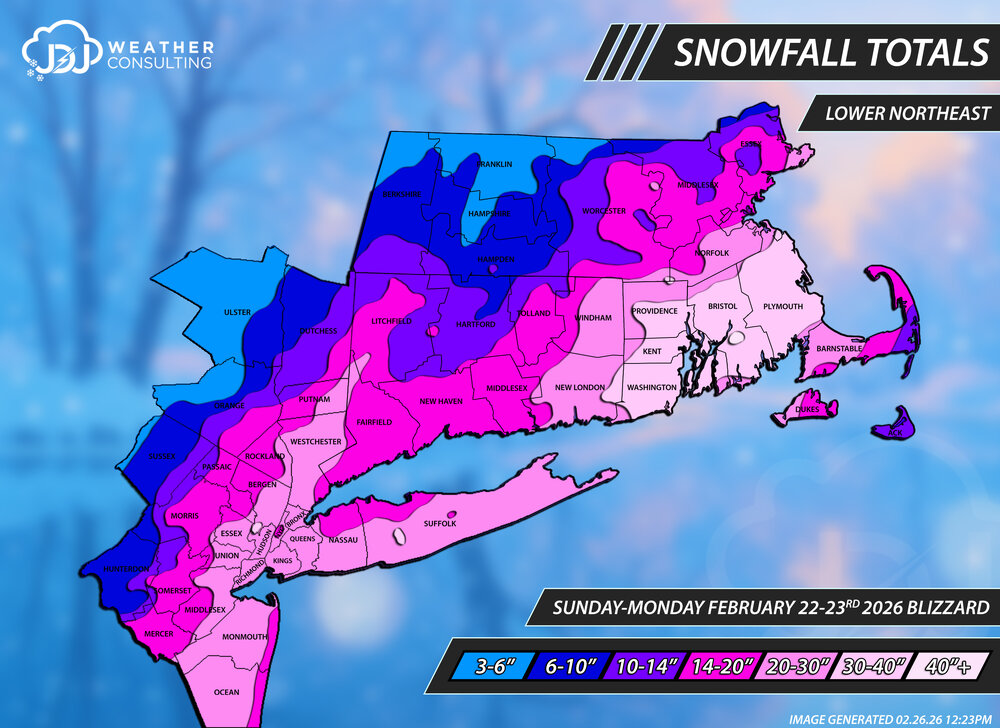
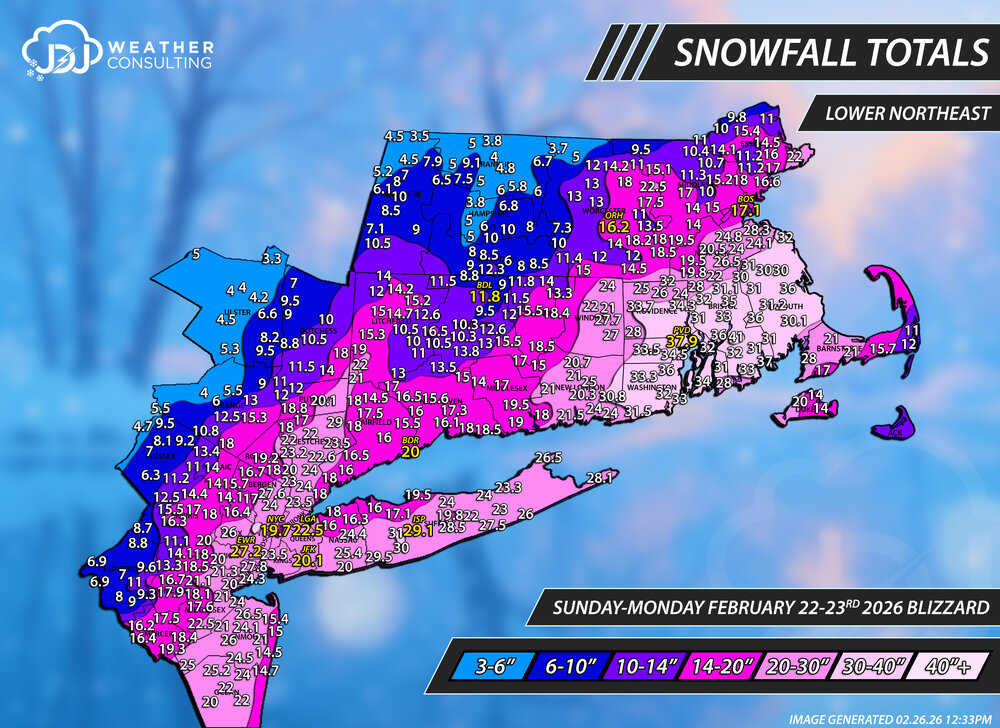
Updated snowfall analysis maps for the Blizzard of 2026. SNE & CT only maps are up as well. This may be updated in the future. A full page with radar/sfc/upper air maps coming soon. https://www.jdjweatherconsulting.com/winter-25-26 Lower Northeast Contours Only Tri-Sate Area
-
A limited edition accordion was just smashed into pieces…
-

E PA/NJ/DE Winter 2025-26 Obs/Discussion
Physicsteve replied to LVblizzard's topic in Philadelphia Region
Honestly think best case is cashing in snow-wise Monday like Euro AI shows, realizing most or all will be melted and washed away by the weekend. -

Outta gas and Outta Time: Early March Winter Storm finale
SnowenOutThere replied to Ji's topic in Mid Atlantic
Hell yeah I’m considered a met -
It won’t matter…all you need is rates. If the rates are good..it sticks. Period!
-
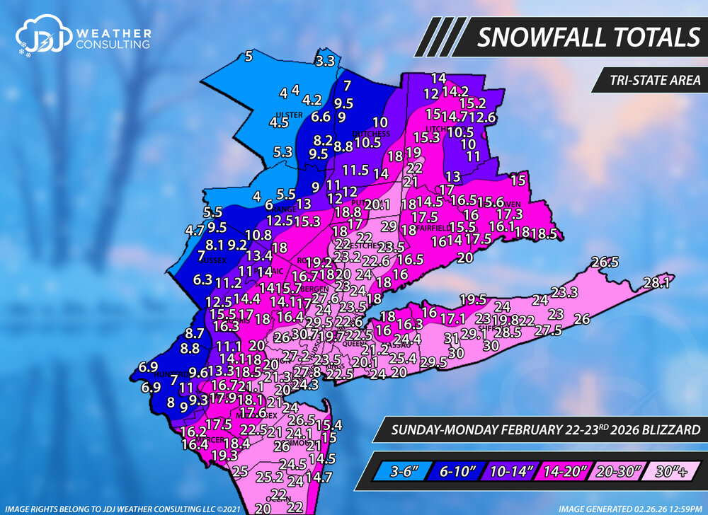
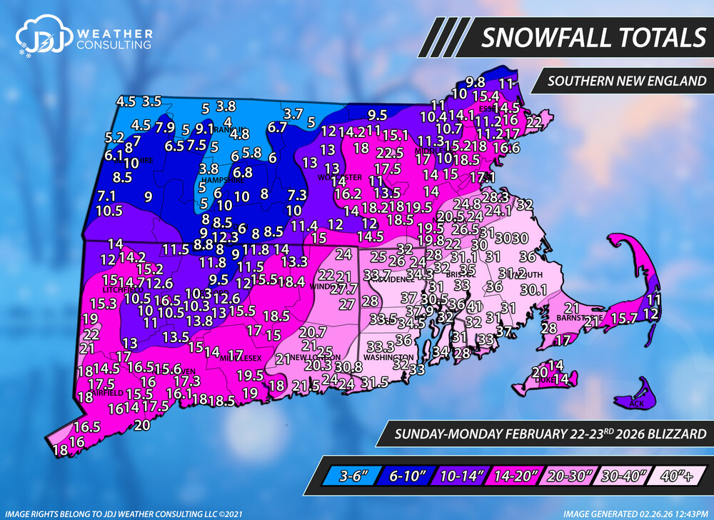
Updated snowfall analysis maps for the Blizzard of 2026. Everything is updated on the site, a full page with surface maps/H5 and radar will come soon. CT and Tri-State only maps are up as well. https://www.jdjweatherconsulting.com/winter-25-26 Lower Northeast Contours Only Southern New England


-
Their average high for winter (DJF) so far is 54.2°. 13.4” of snow so far. Their 2 weeks before Xmas was mostly 60s and 70s
-

Outta gas and Outta Time: Early March Winter Storm finale
psuhoffman replied to Ji's topic in Mid Atlantic
Right but the point is it was LESS WRONG then all the other models day 5-8 and so on a chart of verification scores it would look good. -

Outta gas and Outta Time: Early March Winter Storm finale
TSSN+ replied to Ji's topic in Mid Atlantic
Perfect lol -
Looking season to date totals, if anyone has them, for 3 CT locations; Southbury, Woodbury and Newtown... Thanks in advance...
-
It went from a dusting to a dusting
-

Outta gas and Outta Time: Early March Winter Storm finale
Steckstacks replied to Ji's topic in Mid Atlantic
To me this seems like a storm that the mountains will dry out. No moisture coming from gulf and progressive flow usually kills us. . -
Outta gas and Outta Time: Early March Winter Storm finale
TSSN+ replied to Ji's topic in Mid Atlantic
Ok now out far enough. Ya that’s noting going to get it done. Needs to beef up -
Nothing worse than a met hyping model run that falls on its face
-
Euro is minor
-
Outta gas and Outta Time: Early March Winter Storm finale
TSSN+ replied to Ji's topic in Mid Atlantic
More than the last? -

Outta gas and Outta Time: Early March Winter Storm finale
NorthArlington101 replied to Ji's topic in Mid Atlantic
I think the broader point is that verification scores aren’t gonna translate to specific areas for specific events… just not how it works. You can take or leave them as how a model performs if you want to but it’s kinda the only objective measure And it’s correct to say the AIFS was first to ID a big east coast storm. It was just wrong for us. But thr GFS was even more wrong! -
yeah i wonder why, Euro ai shows a decent hit
-
No. The record for Denver is 40.2° during Winter 1933-34.
-

Outta gas and Outta Time: Early March Winter Storm finale
stormtracker replied to Ji's topic in Mid Atlantic
Just skip this run. It's not horrific like Ji said, but it's pretty paltry


