All Activity
- Past hour
-
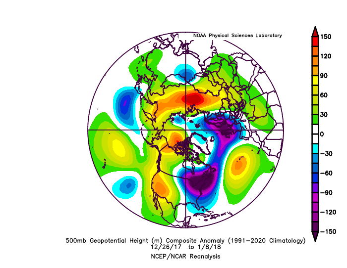
The most significant cold in my area over the last decade was 12-26-18 to 1-8-18. It was mostly Pacific driven. This is why my comment about other factors having a greater influence on the Northeast than the NAO. You can see the generally lower heights over Greenland to Iceland. The best blocking was over Western North America.
-
I just looked at the national weather map and hadn’t realized how bad the smoke was in the northeast and around the Great Lakes.
-
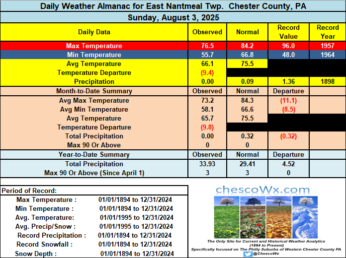
The first 3 days of August have featured temperatures nearly 10 degrees below normal. We see temperatures rebound this PM to near normal with highs in the low to mid 80's. Similar temperatures tomorrow before we turn again a few degrees below normal to close out the work week. Near normal temperatures return next weekend. Rain chances look slight but more clouds and maybe a shower on Wednesday.
-

E PA/NJ/DE Summer 2025 Obs/Discussion
ChescoWx replied to Hurricane Agnes's topic in Philadelphia Region
The first 3 days of August have featured temperatures nearly 10 degrees below normal. We see temperatures rebound this PM to near normal with highs in the low to mid 80's. Similar temperatures tomorrow before we turn again a few degrees below normal to close out the work week. Near normal temperatures return next weekend. Rain chances look slight but more clouds and maybe a shower on Wednesday.
-
Yep that was intense. Had numerous trees down in my neighborhood too. As usual with the east side of any tropical system here-a couple showers but very high wind. Luckily it didn’t hit NC as a borderline cat 2/3, in that case power here could’ve been off for weeks.
-
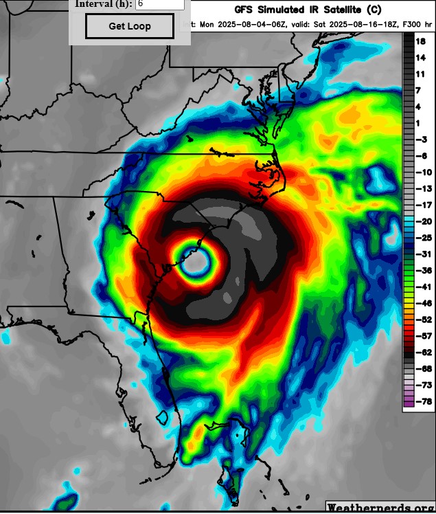
 2 fish storms, possibly 3, depending on how close to shore the one off the SE coast forms, if it forms.
 -
Good day view and this morning but not a cloud to be found

-
Roofers are crazy brave dudes. That is all.
-
krispy erin
-

2025-2026 ENSO
PhiEaglesfan712 replied to 40/70 Benchmark's topic in Weather Forecasting and Discussion
Last cold winter month, yes. But there have been really cold months since JFM 2015, albeit in other seasons, like April 2018, November 2018, November 2019, and June 2023. -
The wind held off in Queens until that line of storms rotated through with the circulation toward the end of the event. Our strongest winds came with sunshine ironically, but they were really strong, the airports gusted to 70mph.
-
Starting next Monday we torch for a week or 10 days then finish out with some more AN days August +1.5
-
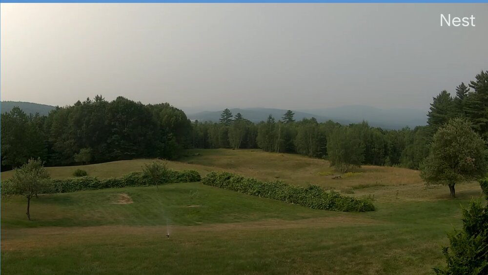
 Hazy look to the sky today. Smoke is back!
 -
49 degrees at 6:30 felt like fall. Chilly CAD with cloudiness should hold afternoon temps. down Tuesday/Wednesday.
-
I'm surprised that you were able to sneak this post in before Climate Change. He loves to promote cold weather records.
-
More spots in the CONUS finished with below average snowfall than above average snowfall for the 24-25 season.
-
 Not until at least my son finishes college (he's only starting high school this fall).
 -
 The area to watch in the coming 1 - 2 weeks off the s central atlantic.
 -
Records: Highs: EWR: 100 (1993) NYC: 100 (1944) LGA: 99 (1944) JFK: 93 (2006) Lows: EWR: 58 (1945) NYC: 55 (1874) LGA: 62 (1964) JFK: 57 (1964) Historical: 1609: Sir Thomas Gates, future governor of Virginia, was on his way to England from Jamestown. On Saint James Day, while between Cuba and the Bahamas, a "most terrible and vehement storm" raged for 44 hours. One of the small vessels in the fleet sank to the bottom of the Florida Straits. Four of the remaining vessels reached Virginia soon after the storm...followed a few days later by three other ships. The flagship, known as Sea Adventure, disappeared and was presumed lost. A small bit of fortune befell the ship and her crew when they made landfall on Bermuda. Although the vessel was damaged on a surrounding coral reef, all survived and spent ten months on the unsettled isle. The Spaniards, though shipwrecked on the island many times, had failed to colonize there. The British claimed the island and quickly settled the subtropical isle. In May 1610, they set forth for Jamestown, this time arriving at their destination. This near catastrophe provided the inspiration and background for William Shakespeare's play, The Tempest. (Ref. The Tempest) 1882 - A vivid aurora was visible from Oregon to Maine, down the east coast as far as Mayport FL, and inland as far as Wellington KS. Observers at Louisville KY noted merry dancers across the sky, and observers at Saint Vincent, MN, noted it was probably the most brilliant ever seen at that location. (The Weather Channel) 1915: Tropical storm from the North Bahamas moved over the Washington, DC area on a northeast track gave 2.34 inches of rain and winds to 46 mph from the SE. (Ref. Washington Weather Records ) 75 people died in flooding at Erie, PA. Many streets were flooded and bridges washed away. (Ref. AccWeather Weather History) 1930: The temperature at Moorefield, WV soared to 112 degrees to establish a state record, having reached 110 degrees the previous day. Widespread drought after April of that year caused some towns to haul water for domestic use, and many manufacturing plants were barely operational.(The Weather Channel) (Ref. Additional Temperatures Listed On This Link) 1930 - The temperature at Moorefield, WV, soared to 112 degrees to establish a state record, having reached 110 degrees the previous day. Widespread drought after April of that year caused some towns to haul water for domestic use, and many manufacturing plants were barely operational. (The Weather Channel) 1961 - Spokane, WA, reached an all-time record high of 108 degrees. Kalispell, MT, set an all-time record with a reading of 105 degrees. (The Weather Channel) 1980 - A record forty-two consecutive days of 100 degree heat finally came to an end at the Dallas-Fort Worth Airport. July 1980 proved to be the hottest month of record with a mean temperature of 92 degrees. There was just one day of rain in July, and there was no measurable rain in August. There were 18 more days of 100 degree heat in August, and four in September. Hot weather that summer contributed to the deaths of 1200 people nationally, and losses from the heat across the country were estimated at twenty billion dollars. (David Ludlum) (The Weather Channel) 1981: This was a day to remember in portions of south central South Dakota as an unusually long lived thunderstorm wind event hit the area. In St. Francis a radio station reported a gust of 86 mph, but that was only the beginning. For the next 20 minutes winds of 50 to 70 mph hammered the area doing massive damage to trees and a few trailers in the area. (Ref. Wilson Wx. History) 1982: The low temperature at Billings, MT was 60°. This began a string of 19 consecutive days on which the low temperature did not drop below 60°, the record longest such streak in August. (Ref. Wilson Wx. History) 1987 - A cold front brought relief from the heat to a large part of the Midwest, while hot weather continued in the south central and eastern U.S. Morning thunderstorms in Nebraska deluged the town of Dalton with 8.71 inches of rain, along with hail three inches in diameter, which accumulated up to four feet deep near the town of Dix. (Storm Data) (The National Weather Summary) 1988 - Thunderstorms produced severe weather from eastern Iowa to Lower Michigan during the afternoon and evening hours, producing golf ball size hail and spawning several tornadoes. A thunderstorm at Maquoketa, IA, produced wind gusts to 75 mph. (Storm Data) (The National Weather Summary) 1989 - Thunderstorms produced severe weather from eastern Nebraska and northeastern Kansas to the Great Lakes Region, with 150 reports of large hail or damaging winds during the afternoon, evening, and nighttime hours. Thunderstorms produced tennis ball size hail at Claremont, MN, and wind gusts to 75 mph at Milwaukee, WI. Thunderstorms representing what once was Hurricane Chantal produced five inches of rain at Grant, MI, and deluged Chicago, IL, with more than three inches of rain in three hours. (Storm Data) (The National Weather Summary) 1994: Boston, Massachusetts had 16 days from July 20 to August 4 giving the greatest number of days with temperatures of 70 degrees or above. (Ref. NOAA Boston Weather Events) 1995: Thunderstorms over northwest Iowa storms grew quickly, producing golf ball to baseball size hail over Palo Alto County near Ayrshire and Webb. As the storms moved south, a copious amount of hail was dropped. Just north of Rush Lake in Palo Alto County, pea-sized hail covered the ground to a depth of 12 inches. The storms then moved into northern Pocahontas County where they dropped softball size hail, which has a diameter of 4.50 inches, just north of Laurens. Golf ball size hail also continued to fall over Pocahontas County near the communities of Pocahontas and Havelock. The storms weakened a bit as they moved into Sac and Calhoun Counties. Crop damage totaled about $335,000 from these storms. Record heat prevailed across parts of the East. Record highs included: Philadelphia, PA: 98°, LaGuardia Airport (NYC), NY: 96°, Wilmington, DE: 96° and Bridgeport, CT: 93°. (Ref. Wilson Wx. History) 1998: College Station, Texas: The last of a string of 30 consecutive days with temperatures greater than 100 °F. 49 such days will be recorded in the blistering Summer of '98. (Ref. WxDoctor) Dallas, TX saw its streak of 29 consecutive days with temperatures 100° or hotter come to an end. It was the second longest streak of 100° plus days in the city's history. Record highs occurred across the southwest including Borrego Springs, CA: 116°, Redding, CA: 112°, Victorville, CA: 110°, Stockton, CA: 109°, Sacramento, CA: 108°, Riverside, CA: 106°, Escondido, CA: 99°, Idyllwild, CA: 96°, Palomar Mountain, CA: 95° and Big Bear Lake, CA: 88° and San Francisco (Airport), CA: 87°. (Ref. Wilson Wx. History) 2006: Washington DC: The temperature at Ronald Reagan National Airport reaches 101 °F the hottest ever for that day in the nation's capitol. (Ref. WxDoctor) 2008: Severe storms moved across northern Illinois and Indiana with tornadoes and stiff winds reported. With tornado sirens blaring, the game at Wrigley Field between Cubs and Astros was stopped as fans were told to evacuate to the lower concourse. Passengers at O’Hare International Airport were evacuated to lower levels of buildings as well. An estimated 350 flights were canceled. 2012: Third of the top ten weather events - Summer Heat Wave. June 22-August 4. Extreme heat that began over the High Plains, expanded to the Fast Coast, and then centered on the Heartland broke thousands of temperature records and resulted in July 2012 edging out July 1936 as the hottest month on record for the contiguous United States. The heat, which was blamed for over 100 deaths, contributed to the drought that affected much of the country. Top 2012 Weather Events (Ref.Weatherwise May/June 2013 volumn 66 /number3 page 17) 2020: Tropical Storm Isaias hit the eastern third of Virginia hardest on Tuesday morning during its brief but destructive journey up the Eastern Seaboard. Several hours of torrential rain flooded dozens of roads, while winds gusting past 45 mph downed trees and put hundreds of thousands of homes and businesses in the dark. The storm left scattered road closures and power outages in metro Richmond and more widespread disruption across the Tidewater region, where winds approached 70 mph. No serious damage was reported in the western half of the state. (Ref. The Richmond Times Dispatch)(Ref. The Richmond Times Dispatch)
-
Can we get a hell ya. Wow another top tenner.
-
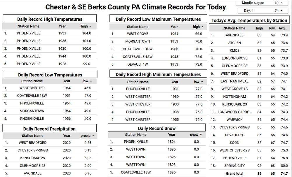
BRR.. .CLIMATE... The low temperature of 41 degrees was observed in Bradford on August 2nd, which tied the previous record set back in 1985. The low temperature of 47 degrees was observed in Altoona on August 3rd, which broke the previous record of 48 degrees set back in 1959.
-

2025-2026 ENSO
40/70 Benchmark replied to 40/70 Benchmark's topic in Weather Forecasting and Discussion
You can always find a random spot that doesn't do well with snowfall even though the overall CONUS did decently last winter. -
-
70 / 60 . Clear cloud-wise but smoke gets in your eyes. Warm mid - upper 80s , smoke may hinder the hottest spots from a 90 return. More cloudy Tuesday but still warm with mid - upper 80s hottest spots maybe to 90 but could be cloudy. We'll see how much rain can get north of SNJ later Wed / Thu AM. The late week and weekend look beautiful. Overall onshore barrage the next 4-5 days before the flow comes around next week warm-hot / humid and wetter overall with tropcial activity heating up. Atlantic ridge remains expanded or anchored off the coast offshore so storms may be steered and aimed towards the SE/EC. 8/4 - 8/8 : near normal - dry overall - (limited 90s to the hottest spots Mon/Tue) 8/8 - 8/12 : Warm - Hot / Humid - wetter (Tropics) 8/13 - Beyond : Overall warmer than normal - periods of heat , Wetter
-
You can always find a random spot that does well with snowfall even though the overall CONUS snowfall was below average last winter.