All Activity
- Past hour
-

Strong Nor'Easter/Hybrid Storm Late September 2026
GaWx replied to Rjay's topic in New York City Metro
Thanks. Do you see it having a chance to transition from cold core, which we all agree it will start as, to ST status? -

October Comes Early: Late September Multi-Hazard Hybrid Storm
weatherwiz replied to WxWatcher007's topic in New England
If there are trees or limbs hanging over an area where kids play, such as a playscape, and there is signs of tree rot or tree damage you could certainly make a case for negligence on the property owner. No different if you say hurt yourself walking through a parking lot of an establishment because of torn up pavement or concrete -
I can already see the models festering in their schemes to create a snow chance in October ... Probably continues deepen these odd fast moving cold knifes that'll eventually mean early Lake Effect cold/LR convection grapple. post the 15th this all gestates into a synoptic chance perhaps. Or not, but the synoptically supportive. **This isn't associated with ENSO
-

October Comes Early: Late September Multi-Hazard Hybrid Storm
WxWatcher007 replied to WxWatcher007's topic in New England
Anyway, back to wx. Our area of interest is still strung out. It's going to take a while to consolidate but when it does this loop is going to be very interesting to look at. -
October Comes Early: Late September Multi-Hazard Hybrid Storm
weatherwiz replied to WxWatcher007's topic in New England
Have to wonder if the NAM is going a bit too wonky with the deepening but it keeps this warm core for some time -

Strong Nor'Easter/Hybrid Storm Late September 2026
MJO812 replied to Rjay's topic in New York City Metro
Nam is a dangerous scenario -
October Comes Early: Late September Multi-Hazard Hybrid Storm
WxWatcher007 replied to WxWatcher007's topic in New England
I'm always fascinated when we hop down this societal rabbit hole. Can't two things be true? Some of the things we do have come to reflect an overly cautious nature. But some of the things we do also aren't the smartest. You can't cancel school on every windy day, sure. But you also can't tell the parents burying their baby oh well, it was just an act of God when you lost their child on your watch. I don't care about your politics, age, or upbringing--nobody is going to want to hear that. Especially if forecasts explicitly said a storm was coming. -

Strong Nor'Easter/Hybrid Storm Late September 2026
lee59 replied to Rjay's topic in New York City Metro
Judging by recent model runs, the offshore track looks to be off the books. Looks like some significant impacts for our area. The coast is taking a beating with erosion, not a good sign so early in the season. -
euro selling decent action late next week
-
Septorcher 2026 Discussion - Endless Summer
dryslot replied to Damage In Tolland's topic in New England
First frost this am, Got down to 35.4°F, Coldest so far this fall. -

October Comes Early: Late September Multi-Hazard Hybrid Storm
Great Snow 1717 replied to WxWatcher007's topic in New England
Correct.. -

Strong Nor'Easter/Hybrid Storm Late September 2026
NJwx85 replied to Rjay's topic in New York City Metro
It will have some tropical characteristics, but it’s generated from baroclinic forcing. There might appear to be an eye, but that’s just dry air near the center. It’s a typical nor’easter that’s being enhanced because of warm SST and proximity to the Gulf Stream. So while it might look like a tropical storm the physics behind it are far different. -
October Comes Early: Late September Multi-Hazard Hybrid Storm
weatherwiz replied to WxWatcher007's topic in New England
That would be some good wind on LI and NJ tomorrow afternoon...probably some significant coastal flooding too -
October Comes Early: Late September Multi-Hazard Hybrid Storm
MJO812 replied to WxWatcher007's topic in New England
Looks like it will go into NJ -

October Comes Early: Late September Multi-Hazard Hybrid Storm
Bostonseminole replied to WxWatcher007's topic in New England
NAM is pretty far west.. -

Strong Nor'Easter/Hybrid Storm Late September 2026
mob1 replied to Rjay's topic in New York City Metro
Big change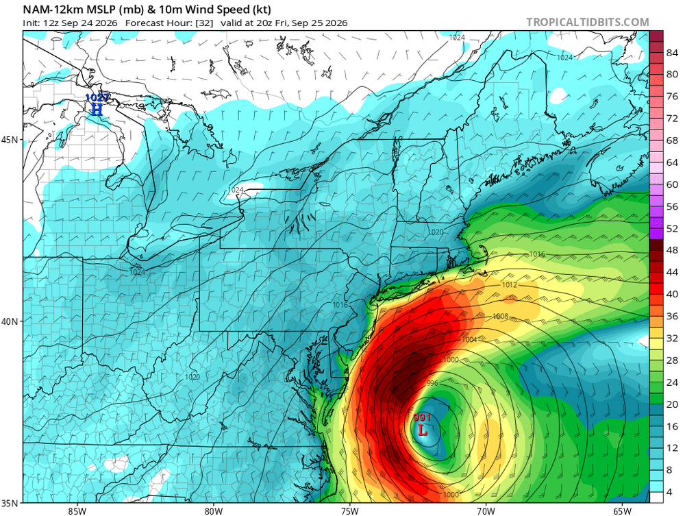
-

October Comes Early: Late September Multi-Hazard Hybrid Storm
CoastalWx replied to WxWatcher007's topic in New England
Convective models will go wild in these setups. -

Septorcher 2026 Discussion - Endless Summer
Typhoon Tip replied to Damage In Tolland's topic in New England
Yeah ...last night with a nearly missed frost here. 37 ping temp but it appeared to really hover around 38 ...whoosk. Chilly. Pretty sure this is ahead of schedule against conventional climatology, ... definitely is so against relative climo associated with CC! 58 now so explosive recovery I can already see the models festering in their schemes to create a snow chance in October ... before the compression of winter allows NINO to take over for whatever that's gonna entail ... Fun year for weather incoming. Doesn't say jack about whether that's coming with winter d-dripper's withdraw symptoms in mind, however -

2026 Atlantic Hurricane Season
olafminesaw replied to Stormchaserchuck1's topic in Tropical Headquarters
Not tropical, but perhaps the closest to a tropical impact we may see this year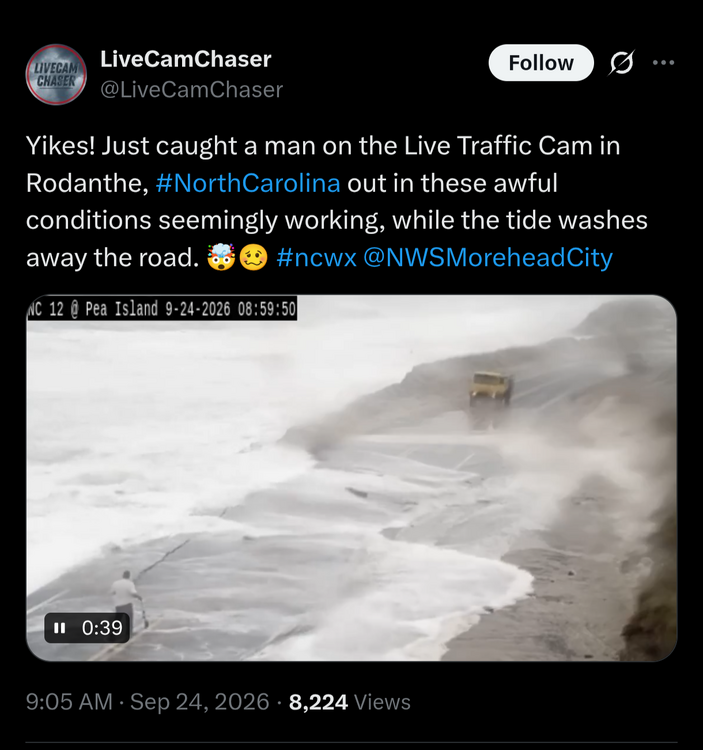
-
October Comes Early: Late September Multi-Hazard Hybrid Storm
Bostonseminole replied to WxWatcher007's topic in New England
HRRR looks pretty cool, but HRRR at 48 hrs.. so idk -
Strong Nor'Easter/Hybrid Storm Late September 2026
mob1 replied to Rjay's topic in New York City Metro
NAM is a fairly significant event for the coast -
Strong Nor'Easter/Hybrid Storm Late September 2026
MJO812 replied to Rjay's topic in New York City Metro
Yep much further west so far -

Strong Nor'Easter/Hybrid Storm Late September 2026
Brian5671 replied to Rjay's topic in New York City Metro
NAM looks west through about hour 20 -

October Comes Early: Late September Multi-Hazard Hybrid Storm
qg_omega replied to WxWatcher007's topic in New England
HRRRR gone wild -

October Comes Early: Late September Multi-Hazard Hybrid Storm
SouthCoastMA replied to WxWatcher007's topic in New England
Definitely part of it. Also, the game can be rescheduled. Not a huge deal