All Activity
- Past hour
-

November 2025 general discussions and probable topic derailings ...
WinterWolf replied to Typhoon Tip's topic in New England
But mornings keep getting later unfortunately…but I get what you mean. Sunsets, sunrises don’t bother me at all. The early darkness is comforting to me. But I understand how it affects some. -
 There seems to be a big perception that most of December will be wintry into and thru the holidays .
 -

November 2025 general discussions and probable topic derailings ...
dendrite replied to Typhoon Tip's topic in New England
19 more days until the sunsets get later. I’m literally counting down the days. -
Who hacked this account?
-

Central PA Fall Discussions and Obs
Mount Joy Snowman replied to ChescoWx's topic in Upstate New York/Pennsylvania
Low of 41 with .01” of rain. Madison was our first ever road trip many moons ago, loved it. Last year we were in Morgantown for the West Virginia game and I met Joe Calhoun at the hotel bar, our long-time local meteorologist on WGAL. Great guy. -

November 2025 general discussions and probable topic derailings ...
Torch Tiger replied to Typhoon Tip's topic in New England
Hopefully 11/20 to 1/20 flies by as quickly as the previous two. We're almost there! -
42 at home on a gloomy day. Day 2 of new job safety training. I coukd get used to working from home lol
-

November 2025 general discussions and probable topic derailings ...
CoastalWx replied to Typhoon Tip's topic in New England
-
Late last November into early December the EPS and GEFS were forecasting the +PNA -EPO to extend through the holidays. But they greatly underestimated the Pacific Jet and we got the big jet extension which lead to the record +EPO and warmer pattern later in the month. I was highlighting the warmer risks back in the threads going into early December last year. Then we got the big January suppression pattern with the record snowstorm on the Gulf Coast. There was a kicker coming into Western Canada at the time that contributed to that suppression. The MJO 8 was really brief in phase 8 on the RMMS last January but we had lingering forcing on the VP charts near the Maritime Continent which may have prevented the Pacific Jet from fully relaxing like our last successful MJO 8 in January 2022. Then in early February the extended EPS was trying to forecast a snowy gradient pattern near NYC. I mentioned that the gradient would probably shift to the north. Then we got the record Great Lakes cutter with the -5SD Greenland block which linked with the Southeast ridge and Toronto hot the record snows. Since the models underestimated the Southeast ridge again. This is why I don’t have any confidence when models show big patterns in the week 2 and week 3 time ranges. If a big pattern shows up under 120 hrs, then I will get on board.
-

Central PA Fall Discussions and Obs
pawatch replied to ChescoWx's topic in Upstate New York/Pennsylvania
I have been seeing Penn Dot shuffling some plow trucks on flat beds lately. Few heading up 15 north. 40 degrees and a little bit of fog. -

2025-2026 ENSO
donsutherland1 replied to 40/70 Benchmark's topic in Weather Forecasting and Discussion
Yes. There were near misses. -
November 2025 general discussions and probable topic derailings ...
dendrite replied to Typhoon Tip's topic in New England
A gloppy 5:1 mashed potato event? -
November 2025 general discussions and probable topic derailings ...
CoastalWx replied to Typhoon Tip's topic in New England
We may squeeze in something minor prior to that but really anything before the end of the first week of Dec is gravy. -

Central PA Fall Discussions and Obs
Blizzard of 93 replied to ChescoWx's topic in Upstate New York/Pennsylvania
Agreed, hopefully we are tracking specific winter storm chances as we get into early December. -
November 2025 general discussions and probable topic derailings ...
CoastalWx replied to Typhoon Tip's topic in New England
That will come early December. As I have said many times. Wait until after first week. -
November 2025 general discussions and probable topic derailings ...
CoastalWx replied to Typhoon Tip's topic in New England
Temp crashed in the fake spots once the clouds cleared. Even here we had clouds until like 5a then we tanked to 30. Low 20s surrounding here. Frosty. -
2025-2026 ENSO
donsutherland1 replied to 40/70 Benchmark's topic in Weather Forecasting and Discussion
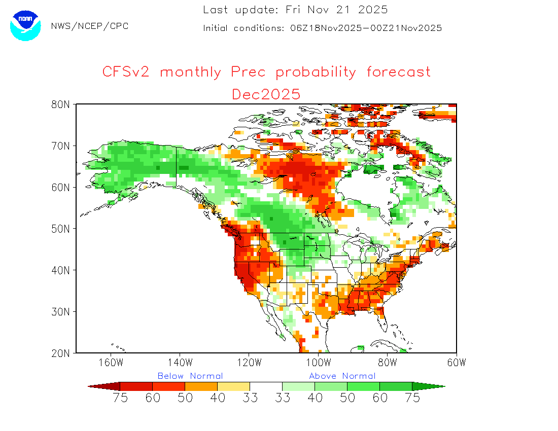
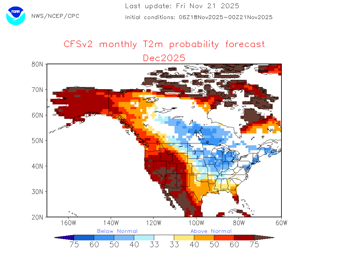
The probabilistic maps from the latest CFSv2 monthly forecasts (just outside its skillful range) appear to be consistent with my baseline thinking (Upper Midwest/Great Lakes-focused cold that spreads eastward, above normal snowfall in the Upper Midwest-Great Lakes Region ( including Chicago to Toronto). Finally, there continues to be no evidence of the kind of buildup of expansive severe cold in the Northern Hemisphere that would produce a severely cold December in the CONUS. This does not preclude the possibility of 1-2 Arctic outbreaks, but those are synoptic events that can't be forecast from this far out. But the path toward an extremely cold month is one that is statistically very unlikely and for which there is no evidence currently to support such claims. Therefore, the Social Media chatter toward that end is pure speculation. The idea that December would rival 1983 is nonsensical. December 1983 (CONUS mean temperature of 25.48°) was the coldest December on record in the CONUS. The last December with a CONUS mean temperature below 30° was December 2009 (29.64°) and that outcome was made possible by extraordinary and persistent blocking in the WPO/EPO/AO domains. Both those frigid Decembers were preceded by Novembers with a much larger deep cold pool in the Northern Hemisphere. So, a logical question would be how such cold would materialize if the deep cold pool is small and there is no indication of 2009-style extreme blocking on the guidance (which can't reliably be forecast from this far out)? If the ingredients aren't present or can't yet be determined to be present, one can't credibly call for such outcomes, especially when they are rare statistical events. Finally, the odds are further tilted against such an outcome by the warming that has occurred in the Northern Hemisphere since 1983. Below are the GISS Arctic region temperature anomalies since 1980.


-
My expectations are higher with the weak PV/ LA Nina and a favorable MJO. I think we get more snow than last winter ( thats not saying much though ) Winter should start to kick in after next week.
-
November 2025 general discussions and probable topic derailings ...
dendrite replied to Typhoon Tip's topic in New England
Sir, this is a weather forum. Please keep it about weather. -

Central PA Fall Discussions and Obs
pasnownut replied to ChescoWx's topic in Upstate New York/Pennsylvania
also in regards to Dec chill being advertised, fwiw, tellies are supportive of Ens guidance, so while not a lock, I'd say we may be loaded :). -
Same can be said if it goes into the bad phases. Just a computer model.
-
If I remember correctly, there were a number of storms that just missed central park with snowfall. Even though I believe the city ended up around 4 inches for the year, with subtle differences it could have been much more. Of course the giant blizzard ending April 1st that year was too warm and east for Manhattan (all the other borrows did ok). However if that same storm occurred 2 weeks earlier, Manhattan could have had a solid 6 to 10 inches. Going into this year with low expectations, I would definitely roll the dice with a 96 / 97 repeat.
-
has a weird splotchy look too suspect the answer is bad news
-
(002).thumb.png.6e3d9d46bca5fe41aab7a74871dd8af8.png)
Central PA Fall Discussions and Obs
ChescoWx replied to ChescoWx's topic in Upstate New York/Pennsylvania
We have not had much sun this week and today will be no different. Rain chances increase late tonight with around 0.20" possible for most areas. We should finally see the sun return tomorrow through Monday with afternoon high temperatures near average at around 50 degrees. Our next rain chances increase by Tuesday late day into Wednesday. Wednesday should be our one well above average temperature day with highs reaching near 60 degrees! We turn sharply cooler by Thanksgiving Day.

-
Central PA Fall Discussions and Obs
pasnownut replied to ChescoWx's topic in Upstate New York/Pennsylvania
if i may, its cooldown part 2. verbatim we cool for turk day into weekend, then a brief warmup as the calendar turns to Dec. AOA 12/3-4 we get 500mb pattern depicted above.