All Activity
- Past hour
-
heh, imagine if this solution turned out warm biased, huh
-

September 2025 OBS-Discussion centered NYC subforum
uofmiami replied to wdrag's topic in New York City Metro
I do, I busted horribly back in fall of last year calling for a cooler November, as I recall. It's called forecasting, you'll never be correct all the time in weather. I just don't delete my posts when the forecast of it ends up incorrect. -

Invest 92L--90% two day, 90% five day odds
GaWx replied to WxWatcher007's topic in Tropical Headquarters
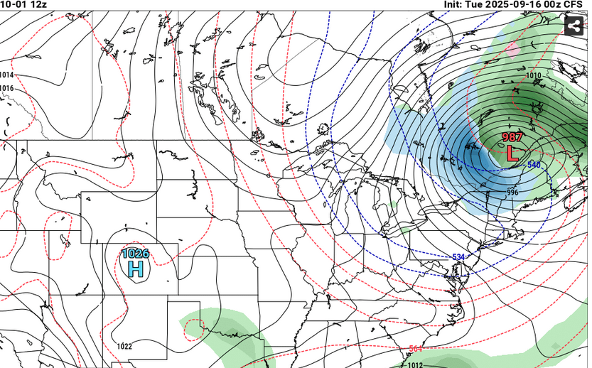
12Z UKMET: center passes just SE of Bermuda NEW TROPICAL CYCLONE FORECAST TO DEVELOP AFTER 36 HOURS FORECAST POSITION AT T+ 36 : 19.4N 49.2W LEAD CENTRAL MAXIMUM WIND VERIFYING TIME TIME POSITION PRESSURE (MB) SPEED (KNOTS) -------------- ---- -------- ------------- ------------- 0000UTC 18.09.2025 36 19.4N 49.2W 1008 42 1200UTC 18.09.2025 48 20.2N 51.3W 1007 37 0000UTC 19.09.2025 60 21.1N 53.9W 1007 33 1200UTC 19.09.2025 72 21.6N 56.5W 1008 28 0000UTC 20.09.2025 84 22.8N 58.1W 1008 31 1200UTC 20.09.2025 96 24.1N 59.6W 1009 30 0000UTC 21.09.2025 108 25.8N 59.8W 1008 37 1200UTC 21.09.2025 120 27.3N 61.2W 1005 46 0000UTC 22.09.2025 132 28.8N 62.3W 1003 44 1200UTC 22.09.2025 144 30.3N 63.0W 1001 44 0000UTC 23.09.2025 156 31.7N 63.0W 1000 49 1200UTC 23.09.2025 168 32.5N 61.5W 998 43 -

2025-2026 ENSO
donsutherland1 replied to 40/70 Benchmark's topic in Weather Forecasting and Discussion
I'm not expecting perfection. But I think boundary conditions, particularly SSTAs are probably the most important variables. The area of warmest Winter 2013-14 North Pacific SSTAs are not a great match with what currently exists. At present, Winter 2020-21 is a better North Pacific Match (again not perfect, but better).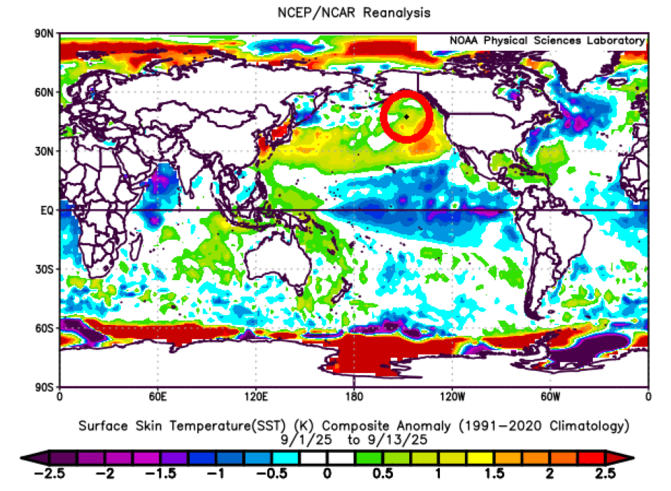
-
Good discussions all! Unlike like the last couple of runs, the 12Z UKMET has no followup TC to 92L.
-

2025-2026 ENSO
PhiEaglesfan712 replied to 40/70 Benchmark's topic in Weather Forecasting and Discussion
I'm hoping we stay ENSO neutral. Second-year ENSO neutrals tend to do well. A warmer version of 1993-94 and 2013-14 could be possible. -

Occasional Thoughts on Climate Change
Typhoon Tip replied to donsutherland1's topic in Climate Change
Boil them frogs, boy -
Humans can't play the long game. We aren't hardwired for it. We'll always be reactive and not proactive. That's why CC is the perfect end for us. It's slow, subtle, and not overly alarming(at first). We won't know we are in serious trouble until it's too late to do anything about it. We probably have already crossed that inflection point. We just scratchin the surface of our good times. Thank god we have social media to distract us as we decline. Phew..
-
I like this Larry, we have one for ENSO so we should also have one for AMO.
-
Out of Service Until Further Notice.
-

September 2025 General Discussion
TheClimateChanger replied to Geoboy645's topic in Lakes/Ohio Valley
Benign weather persists across the region. With another dry day in the offing, Akron will have seen just 0.29" of rain over the past 47 days (August 1 to September 16). August was the driest month on record at Akron with just 0.19" of rainfall. Note - not just the driest August, but driest of any month. Through today, only another 0.10" of rain has been measured in the month of September. This is the driest 47 day stretch on record. The prior record was 0.34" ending on November 17, 1924, but persisting for an additional 4 days [reaching a total of 51 days with just 0.34"]. In addition, a 47-day period ending on July 9, 1988, measured just 0.37" of rain. While a 47-day period ending on October 29, 1963, measured just 0.43" with that tally holding for an additional day. The next chance for rain occurs on Sunday, suggesting the current tally should hold through at least 51 days. -

E PA/NJ/DE Autumn 2025 Obs/Discussion
KamuSnow replied to PhiEaglesfan712's topic in Philadelphia Region
Getting a little light rain here, 67°F. -
Maybe we need a RAMO (relative AMO) in addition to classic AMO sort of like we now have RONI in addition to the classic ONI.
-
Will................. This is sending a signal for the winter.
-

September 2025 OBS-Discussion centered NYC subforum
bluewave replied to wdrag's topic in New York City Metro
Model forecasts change which is nothing new. I was just pointing out to Liberty who enjoys the summer heat that the models were showing 85°-90° potential near JFK. Now they have a faster frontal passage so the forecast is for 80-85°. Still a warm late summer day with a dry downslope flow. Plus these warm downslope flow days usually beat guidance. So a few spots could still see some mid 80s. Back in August I was saying that the 90° potential probably wasn’t over for the warm spots in NJ which turned out to be correct this month. Maybe you should try posting some of your own ideas instead of being more concerned about trying to play gotcha games. I notice that you only chime on the few occasions that the warmest guidance doesn’t verify. But are usually silent when warmth beats guidance.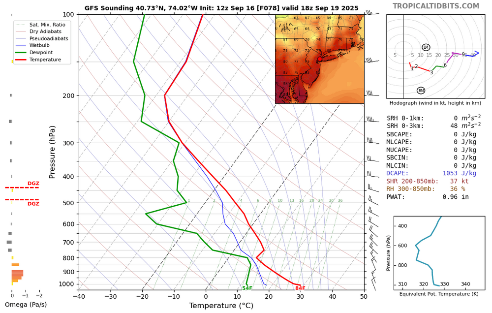
-
Anyone know when LWX radar will be back up?
-
September 2025 OBS-Discussion centered NYC subforum
uofmiami replied to wdrag's topic in New York City Metro
That's why it's deleted but the 90 for Friday posts remain -
September 2025 OBS-Discussion centered NYC subforum
bluewave replied to wdrag's topic in New York City Metro
I posted yesterday that the heaviest rain would stay to our south due to the record blocking to our north which is still the case today. I didn’t mention any specific amounts since the models haven’t been very good recently in that regard beyond a few days out The big picture hasn’t changed much over most of the last year for precipitation. We have been drier than average with the heaviest amounts either completely missing our area or narrowly focusing in a small area like we have seen since May. The next few days look like more of the same. Some of the wetter models have the .50 line getting closer to NYC which would be nice. But not enough to end the drier pattern even if the wetter models closer to .50 verify. In my area along the CT Shoreline we had one of the warmest and driest summers. Vegetation has locally been on the brown side to the lack of rainfall. -
A homebrewed BOC or Caribbean system that affects the Gulf region would have different outcomes based on where in the Gulf it goes. The northern Gulf SST's are a few degrees cooler than the southern gulf. Big SST difference between NE Gulf and SW Gulf. Any home brewed system that goes into the northern Gulf would have some environmental challenges to clear to make MH status. Southern gulf (S Texas or SW Florida) would need to keep their guard up because conditions are ripe in these areas.
-

2025-2026 ENSO
40/70 Benchmark replied to 40/70 Benchmark's topic in Weather Forecasting and Discussion
Anyway, don't get me wrong....I'm not trying to go JB here and start hypng to hell.....but I feel as though seasonal forecasting has really become polarized, and lacks nuance. On the one hand, we have the lust for clicks on social media driving the hype train, and on the other hand we have this group of enthusiasts and pros that have adopted this insipid style of forecating whereas one should forecast warmth first, and think later, if at all. They are both equally as ill advised IMHO, though obviously the latter will verify better over the long run simply due to CC, rather than any actual skill. And I am not grouping people like Chris into that, either.....there are those who forecast warmth that present a great deal of data in support of said outcome and forth in a great deal of effort. However, there are some who have become "lazy", or unimaginative, so to speak. Not directed at anyone specifically...more of a general observation. -

2025 Atlantic Hurricane Season
WxWatcher007 replied to BarryStantonGBP's topic in Tropical Headquarters
It’s a really impressive radar presentation. Look at that banding on the northern and western sides. -
That might be starting to turn around now, Chuck.
-

September 2025 OBS-Discussion centered NYC subforum
LibertyBell replied to wdrag's topic in New York City Metro
Thanks RClab, and thanks for the nice birthday present too!! -
It’s a very impressive radar presentation. It’s faux tropical but it’s legit.
-
September 2025 OBS-Discussion centered NYC subforum
LibertyBell replied to wdrag's topic in New York City Metro
Thanks Don, I'm glad the sunshine hung around for my birthday!!


