All Activity
- Past hour
-
Thanks for the curse. Mediocre Christmas to you!
-
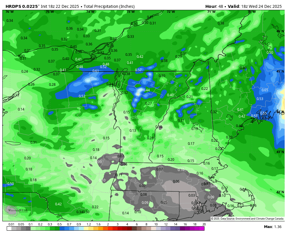
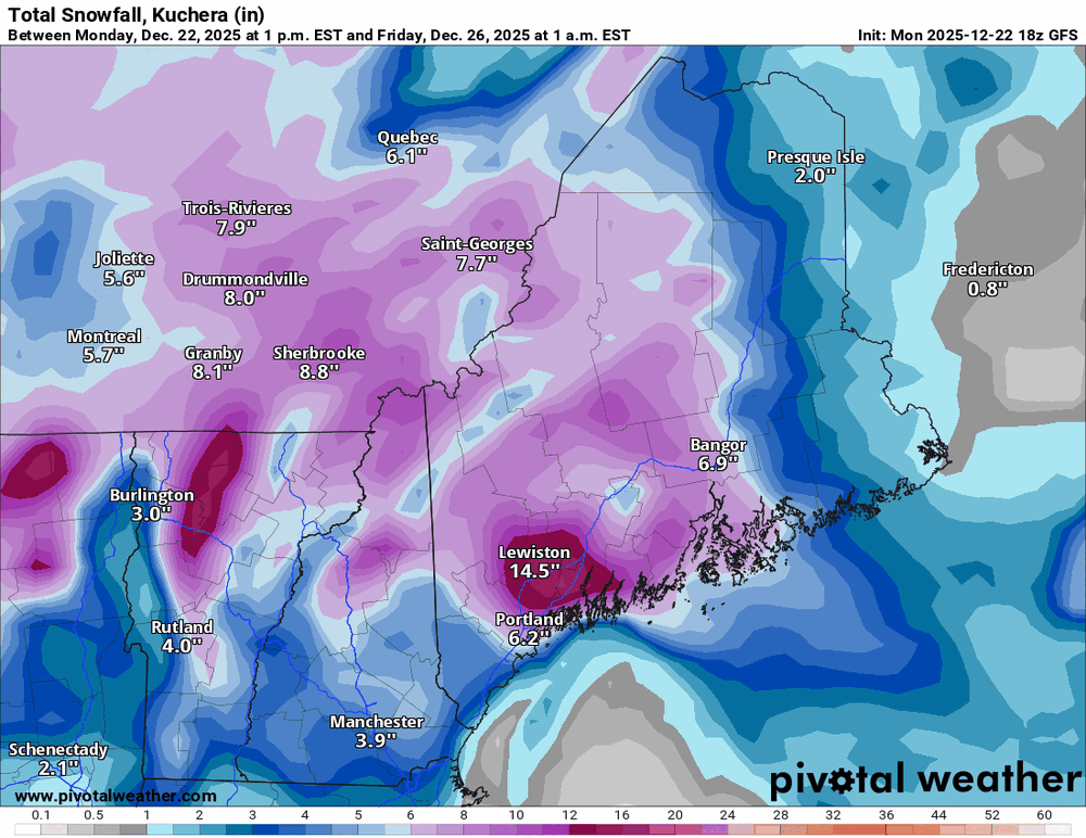
Whats really cool with the pivotal map is my lat/long numbers is pretty much that period between the 14.5 on all their maps.... lol
-

White Christmas Miracle? December 23-24th
moneypitmike replied to Baroclinic Zone's topic in New England
Updated GYX map. Looks like it might be a PWM-Belfast coup. -
 Have you considered reading the thread to make sure that everyones expectations are up to snuff for you?
 -

Pittsburgh/Western PA WINTER ‘25/‘26
Mailman replied to Burghblizz's topic in Upstate New York/Pennsylvania
Some sort of wintry mix here. -
 if you compare temperatures when the precip moves in compared to last event, it's going to be colder this time around. Last time the temperatures got colder as the event got going, this event is the opposite it'll warm up as the event starts departing. Also this event is a bit smaller with precipitation amounts but like i said it is colder this time around!
 -
Windy day. I loosened it just enough so I could get a good shot when the wind picked up.
-
It looks good for @mitchnickand points north, and has been like that for the past 3 model runs (not just the GFS) IMO.
-

White Christmas Miracle? December 23-24th
powderfreak replied to Baroclinic Zone's topic in New England
We take the herpes up this way.
-
I guess I'll take number 18 with extra fries please
-
 Last event featured a much colder airmass before the event (it did modify by the time precip moved in). Also, we remained snow during the entire event. Totally different set ups. We had thunderstorms the other day and it was 40 degrees in Fairfield CT today. 36 now. I am not expecting anything more than an inch here on the coast. You’re entitled to your opinion. I genuinely hope you’re right and I’m wrong. I just don’t see it for us on the coastal plain and city.. .
 -
That said, I wonder if this will go too far north despite the other models. Will track - wish was on Christmas instead.
-
Remember this.............. Persistence can be a very good thing. How many times has a threat looked good on one run and been gone the next run??
-
Not much different on the mean compared to 12z. Noise. Y'all get too goddamn granular on the differences between runs. 18z is a hold.
-

Central PA Winter 25/26 Discussion and Obs
WmsptWx replied to MAG5035's topic in Upstate New York/Pennsylvania
URGENT - WINTER WEATHER MESSAGE National Weather Service State College PA 550 PM EST Mon Dec 22 2025 PAZ025>027-231400- /O.NEW.KCTP.WW.Y.0026.251223T0600Z-251223T1400Z/ Blair-Huntingdon-Mifflin- Including the cities of Lewistown, Huntingdon, Mount Union, and Altoona 550 PM EST Mon Dec 22 2025 ...WINTER WEATHER ADVISORY IN EFFECT FROM 1 AM TO 9 AM EST TUESDAY... * WHAT...Mixed precipitation expected. Ice accumulations around a light glaze and possibly a coating of snow. * WHERE...Blair, Huntingdon, and Mifflin Counties. * WHEN...From 1 AM to 9 AM EST Tuesday. * IMPACTS...Plan on slippery road conditions. The hazardous conditions could impact the Tuesday morning commute. * ADDITIONAL DETAILS...Temperatures hovering around freezing overnight lead to reduced confidence in potential for impactful icing, but motorists should be alert for changing road conditions. PRECAUTIONARY/PREPAREDNESS ACTIONS... Slow down and use caution while traveling. The latest road conditions for the state you are calling from can be obtained by calling 5 1 1. && $$ For more information from the National Weather Service visit weather.gov/StateCollege Banghoff/BaucoADVISED -
White Christmas Miracle? December 23-24th
moneypitmike replied to Baroclinic Zone's topic in New England
Right on me noggin! -

December 2025 regional war/obs/disco thread
TauntonBlizzard2013 replied to Torch Tiger's topic in New England
Basically two camps on the GEFS, good bit and whiff. Not much in between -
fair enough...let's see what happens
-
I actually disagree, it's not really marginal, it's actually colder than the last storm to begin. It's probably going to accumulate for a bit and end as white rain if you ask me
-
I think the problem is the storm itself is mainly just slower so the high isn’t as ideally placed by the time it arrives. You can see the progression of the storm slowing down run to run on the GEFS member MSLP graphic
-
Gfs is usually wrong and too suppressed in this range. Needs some support from cmc and ukie if I'm going to buy it
-
-
-
what is your reasoning for this? Any real scientific reasoning or you are just wishcasting like snowman
-
Torchmas?? How warm do u think it will be??