All Activity
- Past hour
-

WELCOME ABOARD INVEST 96L (30/60)
BarryStantonGBP replied to BarryStantonGBP's topic in Tropical Headquarters
-
2025 Atlantic Hurricane Season
BarryStantonGBP replied to BarryStantonGBP's topic in Tropical Headquarters
-
2025 Atlantic Hurricane Season
BarryStantonGBP replied to BarryStantonGBP's topic in Tropical Headquarters
-
 hopefully next week will be the last heat wave of the year..
 -
2025 Atlantic Hurricane Season
BarryStantonGBP replied to BarryStantonGBP's topic in Tropical Headquarters
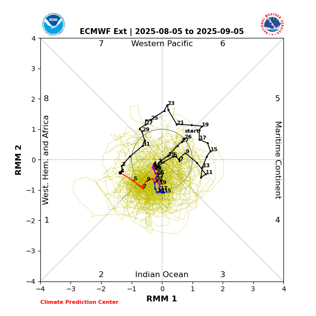
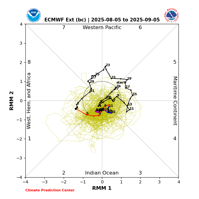
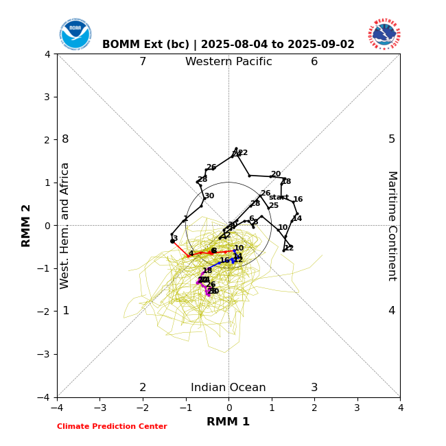
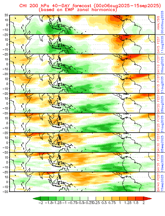
MJO forecasts wave propagation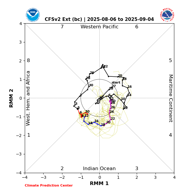
-
Good ole JB, LOL
-
 Didn't expect a shower but getting one.
 -
Yeah. The SST/Atmosphere correlation should become more Set as we get into Fall and Winter. If we get the tripole SST config in the NATL , along with the favourable QBO we should be in business as far as upstream blocking. We need to do a run on west based nina/ east based nina combo composites ,if it can be done. If we can find the Year's with that Configuration , should be able to. Maybe Chuck over in the MA can. He's good at that stuff.
-
 For solar? Unfortunately our house doesn’t have good siting for solar being at the base of a hill. We do seek out energy suppliers that supply solar and wind to the grid. And we burn B20 for heat which I wish we could do more.
 -
It seems to have been raised to 65kt at 36H in the 5pm discussion. “…The global and regional hurricane model fields shows Dexter's metamorphosis, with to development of frontal features as the wind field becomes quite asymmetric. In fact, the maximum sustained winds in 24-36 h are likely related to a sting jet that curves cyclonically around the cyclone's western flank during this time frame. The hurricane-regional models, and even the most recent 12 UTC ECMWF run show winds up to hurricane-force in the southwest quadrant. Thus, the latest NHC intensity forecast will now explicitly show a 65-kt extratropical cyclone in 36 h. After occlusion, the low will slowly weaken through the remainder of the forecast period, ultimately dissipating by early next week in the far northeastern Atlantic. FORECAST POSITIONS AND MAX WINDS INIT 06/2100Z 40.0N 56.3W 45 KT 50 MPH 12H 07/0600Z 40.6N 53.5W 50 KT 60 MPH 24H 07/1800Z 41.9N 49.3W 60 KT 70 MPH...POST-TROP/EXTRATROP 36H 08/0600Z 43.5N 45.3W 65 KT 75 MPH...POST-TROP/EXTRATROP 48H 08/1800Z 44.8N 41.5W 50 KT 60 MPH...POST-TROP/EXTRATROP 60H 09/0600Z 45.5N 37.1W 40 KT 45 MPH...POST-TROP/EXTRATROP 72H 09/1800Z 46.0N 32.5W 35 KT 40 MPH...POST-TROP/EXTRATROP 96H 10/1800Z 47.0N 24.5W 30 KT 35 MPH...POST-TROP/EXTRATROP 120H 11/1800Z...DISSIPATED $$ Forecaster Papin “
-
Very interesting. If you look at the radar loop, you'll see there was a cell near Middletown Delaware that then formed a cluster of showers that started to move Northwest across Northeast Maryland and continuing to do so while the main area precipitation is moving from Southwest to Northeast
-
What causes something to back to the west?
-
JB hinting to a December to Remember because of something something late hurricanes, something something, cold summer period, something something, probably also undersea seismic but I didn't get that far. All that's left is to bring it home.
-
Felt good today, hopefully the heat is subdued.
-
One of the X replies to Mr. Gross has a handle “Real Alfred E. Neuman”
-
I believe one of the issues with wind and solar energy is that it is about 30 to 40 percent efficient at converting their energy to electricity. Oil and gas have much higher efficiency ratings. I'm sure we will continue to make progress in efficiency improvement for renewables as time goes by. In the mean time oil and gas will be number one if folks want to keep their standard of living the way it is. There are plenty of alternatives that I believe will some day take over and oil and gas will go by the way of the dinosaur. I have a hybrid pick up, great gas mileage and no worries about how far I have to travel. I think a good choice as we gradually go from oil to alternatives.
-
 I'm starting to dread next week from now lol
 -
 Under mainly cloudy skies, the temperature topped out at 79° today in New York City. The remainder of the week will see temperatures average somewhat below normal. Highs will mainly be in the upper 70s and lower 80s with lows falling into the upper 60s in New York City. A new round of heat could begin to develop on Sunday Parts of the region could see a return of 90° or above heat. The probability of extreme heat has increased in recent days. The ENSO Region 1+2 anomaly was +0.4°C and the Region 3.4 anomaly was -0.3°C for the week centered around July 30. For the past six weeks, the ENSO Region 1+2 anomaly has averaged +0.37°C and the ENSO Region 3.4 anomaly has averaged -0.08°C. Neutral ENSO conditions will likely continue through the summer. The SOI was +0.79 today. The preliminary Arctic Oscillation (AO) was +0.312 today.
 -
81 for a high today, now 74. Cooler than normal, felt good.
-
Thanks for the heads up, had noticed it was dark to my east. Looks like it will rain here too
-
4.19" so far. High of 70.0 at 5:50am. Been just below that the whole day.
-
 Forky is my favorite!! Unhappy I only present actual real raw and unaltered data (which I correctly and appropriately source)....which somehow becomes a "mental illness" because I dare to present it without the post hoc adjustments he yearns to see. Any raw data even in one suburban big city county that fails to support his climate religion in his "interesting" world view becomes a mental illness....Funny times we live in!!
 -
 But our safety standards are much higher than what Chernobyl had.
 -
If that's the case, China will be leading the world into the future, Don.
-
 the tragedy of chernobyl is still ongoing and will continue after we are gone. it is hardly the past.


