All Activity
- Past hour
-

Central PA Winter 25/26 Discussion and Obs
DDweatherman replied to MAG5035's topic in Upstate New York/Pennsylvania
3k Nam made a big move as well towards the snowier camp. Lots more phasing earlier on. -
Hrrr past hour 18 is as we know suspect
-

Central PA Winter 25/26 Discussion and Obs
GrandmasterB replied to MAG5035's topic in Upstate New York/Pennsylvania
Today is Mickey’s day to shine! -
Jeez that NAM is so close. Right as it starts to deliver it gets kicked SE. How can it continue to gain latitude at this juncture? Earlier phase?
-

Is we back? February discussion thread
TauntonBlizzard2013 replied to mahk_webstah's topic in New England
I mean, statistically, we’re due to start rounding the corner anytime now. I think we’re done with appreciable snow here -
I haven't been paying any attention to this, but this morning's HRRR has me in the upper 50s Sunday 1pm while the NAM 3k has me in the upper 30s. So, I see everything is locked down.
-
Central PA Winter 25/26 Discussion and Obs
GrandmasterB replied to MAG5035's topic in Upstate New York/Pennsylvania
Could be an interesting day of model watching. -
Models honing in at least a 2-4" storm, but very close to a biggie
-
As soon as Ginxy goes wild, models go warmer.
-
It's much more likely to be a NYC south event than further north as it still gets kicked east. Central NJ has best chance
-
Because it was 400 miles SE of us 4 days ago.
-

Central PA Winter 25/26 Discussion and Obs
Superstorm replied to MAG5035's topic in Upstate New York/Pennsylvania
Might have to start thinking about advisories . -
To be fair the nam and euro were pretty identical the last 2 runs. We don’t know what the euro will show this run yet!
-
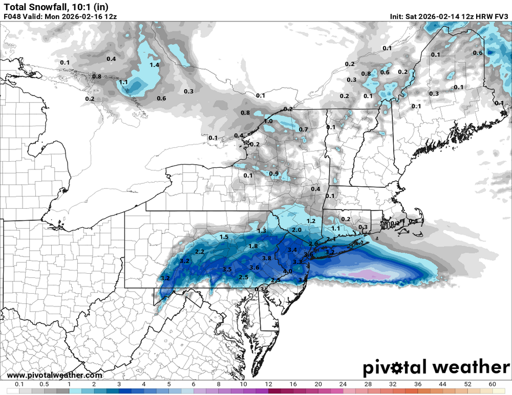
fv3 increased
-
Enjoy.your visit! They brine in July, its normal we are used to it. I think the auto mechanics have their hand in it somehow.
-
Looks like Spring is coming
-

E PA/NJ/DE Winter 2025-26 Obs/Discussion
Newman replied to LVblizzard's topic in Philadelphia Region
NAM is widespread 3-5", lolis of 6" across SE PA. I do think this is one of those overamped NAM runs, especially with how stark the difference in that NS wave is from last run. Really want to see Euro jump on board with a sharper NS wave. -

-
The snow alg on wxbell is flawed for the AIFS ensembles. It seems to count anything remotely close as snow. I tried to figure out what’s wrong but it just seems like someone accidentally set the freezing temp as 35 instead of 32 lol. It’s not the model it’s the clown snow map wxbell makes.
-
Is we back? February discussion thread
TauntonBlizzard2013 replied to mahk_webstah's topic in New England
Next week doesn’t look particularly exciting to me right now for this area. Closing on on March -
34 / 18 on the way to mid / upper 40s in the warmest areas. Storm may be back on Sunday evening into Mon, then overall warmer and perhaps wetter week (thu-fri) , first shot at 50s Tuesday after a possible snowstorm. Looks to continue an active period 2/22 and beyond hovering near avg.
-
Ya no doubt I mean a huge bust in the short term on all guidance only to tease us lmao ..
-

E PA/NJ/DE Winter 2025-26 Obs/Discussion
Kevin Reilly replied to LVblizzard's topic in Philadelphia Region
Well maybe we need the NAM vs GFS Warmer wetter vs Colder dryer Card here. -
It still kicks SE rather than comes up to us.. one more tic like that with northern stream should allow it to come north more . Might be too late for tics that big 36 hours out
-
How I wish the Nam and Gfs would shove it right up the USB port of the Euro on this one.


