All Activity
- Past hour
-
Just read about a fairly rare SSW taking place over the South Pole. The article said that SSWs that happen there in August-October generally saw BN temps over the Central and Eastern U.S., and a warm Europe the following D-F.
-
It's Wed. Time for Raven's fans to move forward. Hopefully the Ravens, at home, don't do what they did last season in game 2- play flat and down to their competition and lose. That was a true Harbaugh special- blowing a late 10 point lead, AND ultimately losing to an inferior team. The Raiders and Gardner fucking Minshew? lmao. Made him look like Dan Marino. Flacco would love to do it, but he is a dinosaur. Ravens better get control and keep it for 60 mins, or it might be a second straight 0-2 start.
-

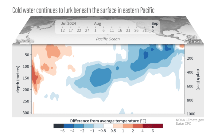
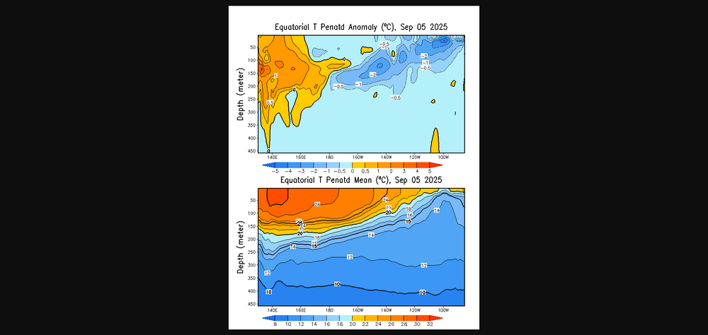
2025-2026 ENSO
michsnowfreak replied to 40/70 Benchmark's topic in Weather Forecasting and Discussion
The entire pattern was definitely EVERYTHING going right. And everything busted in our favor. In 150 years of data, 2013-14 ranks for Detroit: Total Snowfall- #1 1"+ Snowcover Days - #1 6"+ Snowcover Days - #1 12"+ Snowcover Days - #1 Cold- DJF #8, NDJFM- #4 And constant wind for drifting snow. Rural open areas in Monroe County, MI (between Detroit & Toledo) had snow completely bury some barns. -
2025-2026 ENSO
michsnowfreak replied to 40/70 Benchmark's topic in Weather Forecasting and Discussion
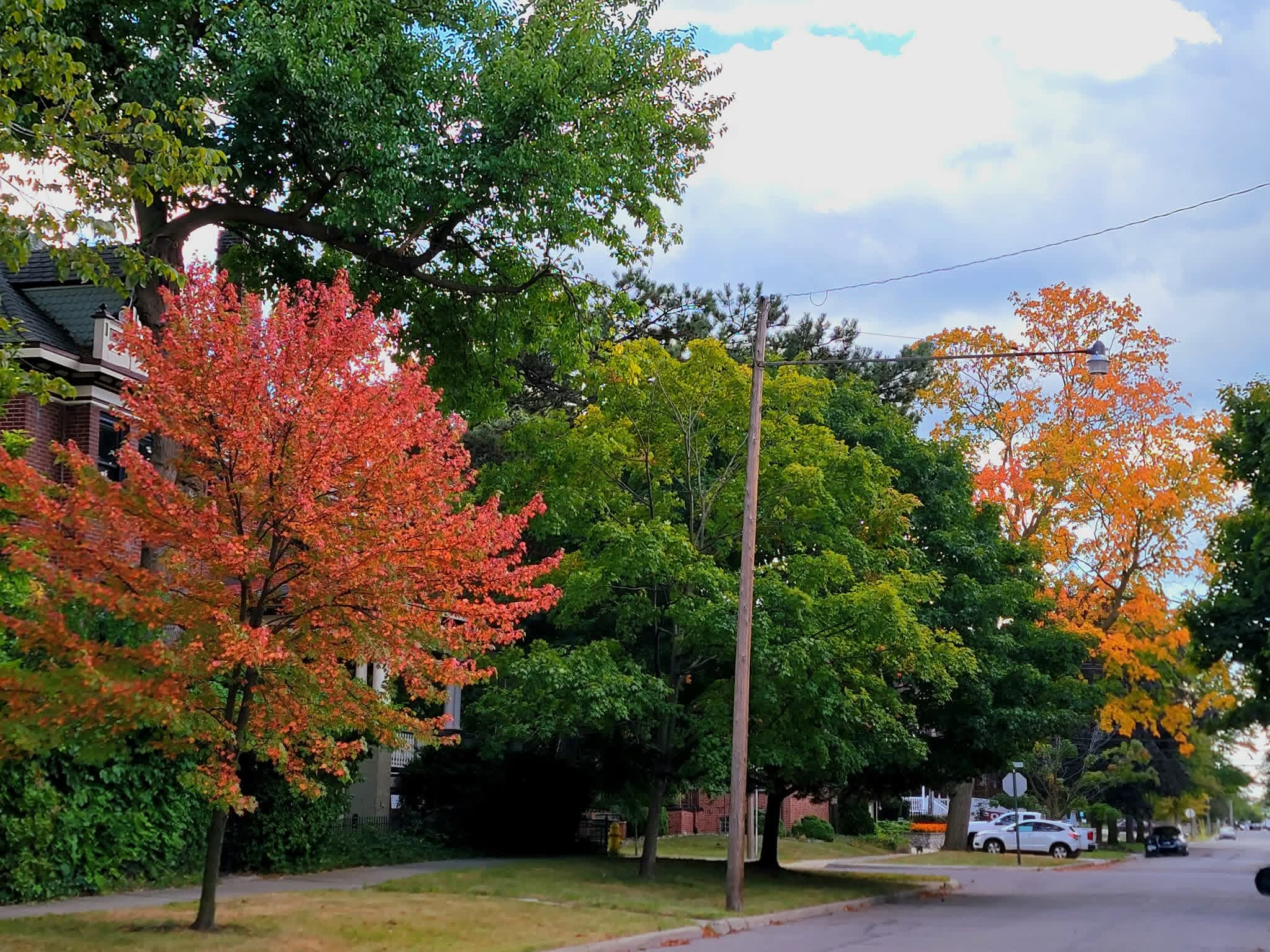
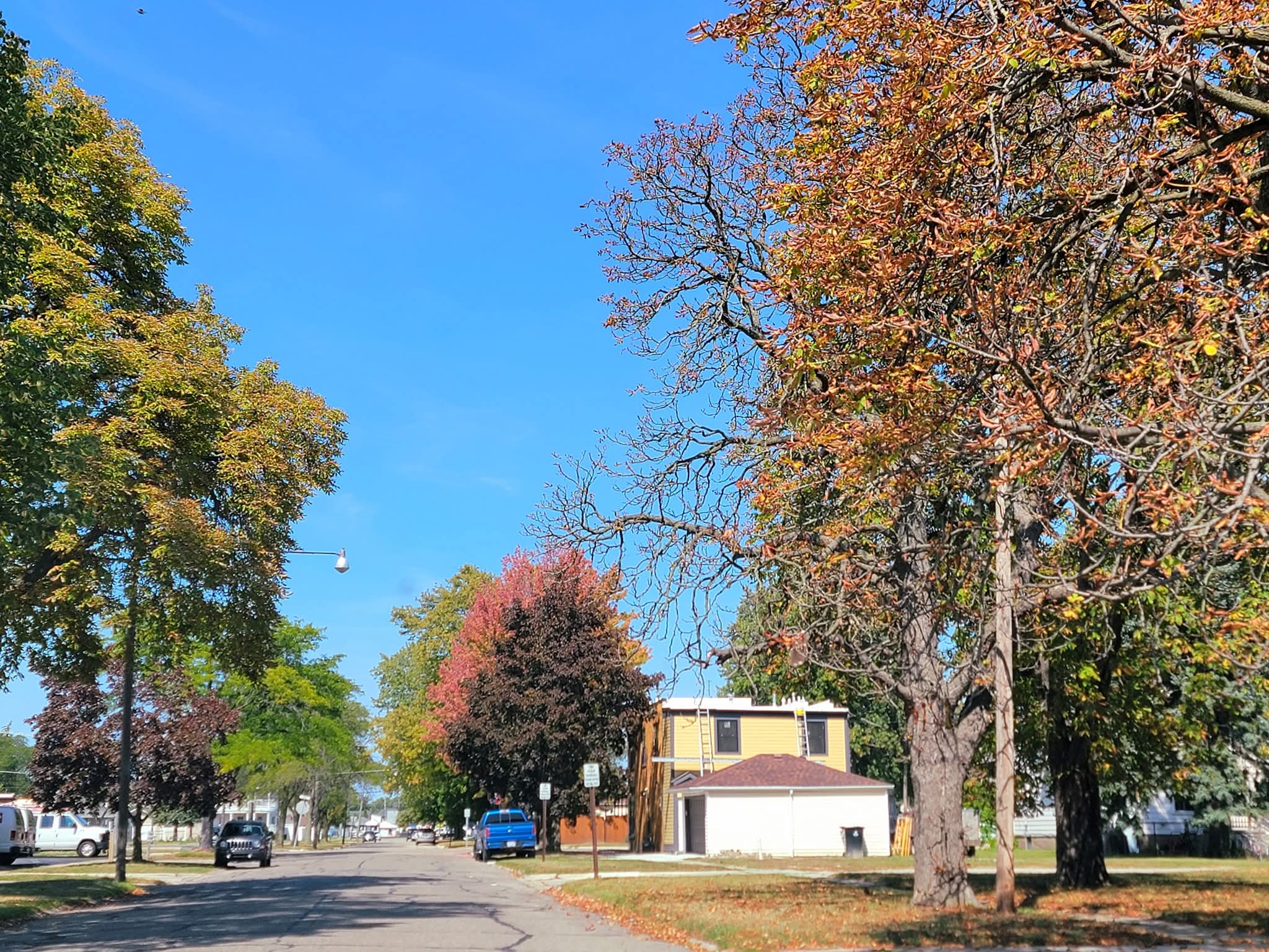
It was the 6th coldest Aug 25-Sept 7 period at Detroit, but coldest since 1935. Color is coming on earlier than normal as well.

-
2025-2026 ENSO
michsnowfreak replied to 40/70 Benchmark's topic in Weather Forecasting and Discussion
I understand that, I just meant that if a pattern in place is going to produce a lot of cold and snow, nothings going to stop it. -
Dude- Not a single member of the local or national media, in discussing this latest Ravens collapse, acknowledge that Lamar's post game mention of cramping had any significant impact on Harbaugh's monumentally wrong decision to punt. In most cases it is barely a mention, or not at all.. They are killing Harbaugh, and rightfully so. Like I said, that was Lamar giving some cover to his coach for making that (fucking dumbass) decision. Let it go lol. Lamar is a gamer, and I guarantee you he wanted to end that game then and there. eta- Maybe read what I posted above.
-

September 2025 OBS-Discussion centered NYC subforum
Stormlover74 replied to wdrag's topic in New York City Metro
euro did this last month and busted badly. could still happen but right now if its alone its probably off -
Not a big fan of this blog overall, but it has its moments. Imo this one is spot on, and worth the read. Not anything a true ravens fan doesn't already know- but well constructed and a great synopsis of how/why we have gotten to this point with the Ravens under Harbaugh. https://russellstreetreport.com/2025/09/10/street-talk/harbaugh-mirror/ Related, and also good: https://russellstreetreport.com/2025/09/09/street-talk/harbaugh-conservative/
- Today
-

September 2025 OBS-Discussion centered NYC subforum
jm1220 replied to wdrag's topic in New York City Metro
If the low can close off and dig west of us, we’ll get a moist fetch off the ocean. If not, probably cloudy and nasty. -
Charlie Kirk shot and if the video online is real
-
Cloudy day with spits and drizzle. Getting a decent shower now. A couple hundredths in the gauge. Currently 66.
-

2025-2026 ENSO
Stormchaserchuck1 replied to 40/70 Benchmark's topic in Weather Forecasting and Discussion
We haven't been seeing a big Aleutian ridge though. It looks like a vortex over the Arctic circle will get down below 4950dm tomorrow! That is probably record breaking, occurring just north of Russia and coming in close to -500dm. These vortexes over the last few weeks have been something, in the last few days of August we also had a sub-5000dm vortex over the Arctic circle. These extremes are similar to like Cuba hitting freezing. -

Pittsburgh PA Fall 2025 Thread
TheClimateChanger replied to TheClimateChanger's topic in Upstate New York/Pennsylvania
Will be interesting to see whether the Youghiogheny River Lake approaches the lows of last autumn. Currently, around 1415.8' ASL. Looks like it fell to around 1,369' in early November 2024, although I'm not sure of the exact low. Further research suggests a low of about 1,362' in December 1998, and a value in 1991 of about 6' higher than that. The December 21, 1998 low was said to have been exceeded twice, in 1954 & 1957. Source: A bridge to the 19th century Not sure we reach as low as last fall unless October is dry, but decent odds of dropping below 1,400' again. Not sure when the "ghost bridge" becomes visible. -
2025-2026 ENSO
Stormchaserchuck1 replied to 40/70 Benchmark's topic in Weather Forecasting and Discussion
The Apr-May SLP pattern in the Atlantic was a giveaway.. something to look at in future years. Pattern never really supported a major warming of tropical Atlantic SSTs. -
@bluewave @donsutherland1 Lack of eastward MJO propagation, -IOD and persistent strong trades has lead to a deep -AAM and La Niña like regime
-
Top 10 afternoon
-
Maybe the time has come to rethink parameters such as SSTs/AMO and ENSO for seasonal hurricane forecasts….
-
Congrats Maine!!!
-

September 2025 OBS-Discussion centered NYC subforum
Brian5671 replied to wdrag's topic in New York City Metro
Cutoff lows notoriously difficult with precip placement. But would be nice to get another dump of rain and on a Monday-that would be great -

September 2025 OBS-Discussion centered NYC subforum
FPizz replied to wdrag's topic in New York City Metro
CMC wet east of NYC, drier west, but other models have nothing -
September 2025 OBS-Discussion centered NYC subforum
Brian5671 replied to wdrag's topic in New York City Metro
Euro wet for next Monday -
https://www.cpc.ncep.noaa.gov/data/indices/RONI.ascii.txt Enso is about similar this year as it was last year,to this date anyways
-
That is what happens with wishcasters...lol
-

September 2025 OBS-Discussion centered NYC subforum
wdrag replied to wdrag's topic in New York City Metro
I'll need to wait this out... one thing I didnt see was EC AI was almost nothing. It could be the EC suite (non AI) is too strong and too far southwest with the 5H vort plunging sdwd from south center Canada with the resultant sfc response too robust here. Would make this a period of waa showers Sunday afternoon and maybe cool frontal showers Monday. I do think its best to play temps conservatively and cooler in this pattern for another 10 days and wait this out a bit but I plan on showers Sunday afternoon and possibly right into Monday night. Patience... at least for me til a I reconsider later on. 12z WPC D4-6 guidance has boosted qpf a bit and I think that right... dont plunge into the unusual heavy solution till we have more confidence. Lets not say its a nice end to the weekend beginning of next week.