All Activity
- Past hour
-
another snowless March for many of us
-
Some stats for Winter '25-'26 for me: -One record low on 12/5 -Lowest temp of -10 on 2/9 with a total of 9 below zero lows, the most since '14-'15. 29 below 32 days, same as last winter, average is 22 for me. Longest streak of below 32 days was 9, the most since '17-'18. -Total snowfall is 46.3", which is +5.1" for me. I jinxed nyself with snowfall after I pushed all my banks back on 1/26. Below is the monthly snowfall and how it compares to average. -Nov snowfall: .2" (-1.5") -Dec snowfall: 17.0" (+7.6") -Jan snowfall: 21.3" (+11.4") -Feb snowfall: 6.6" (-7.5") -Mar snowfall: 1.2" (-5.2")
-
Yup. Pouring here although some of these reflectivities are brightbanding. Hopefully we can wetbulb assist this airmass to more forum members.
-
A moderate el nino would be nice for a change. We haven't had a true one since 2002-03. Closest we had was 2006-07 (but that stalled at 0.9 on the ONI and RONI) and 2009-10 (but that went over 1.5). Moderate el ninos seem to be the sweet spot for good winters in the Eastern US. The only one that didn't really pan out was 1994-95, but that was due to a -PDO, and even then, we got one good month of winter weather (February).
-
I cant remember a recent Spring that had this many temperature swings. One day I'm having to blast my furnace & space heaters, the next, screen doors open and window fans blasting. I've been trying to avoid uncovering the AC units, but with this warm stretch, and people visiting on Easter, I don't think I have a choice.
-
2nd to this

-
Expect the cooling shits to arrive NNE to SSW by this afternoon starting NE zones. Brian's already pretty well f'ed while Kevin might spare some humanity. Front will wobble around along the Pike tomorrow but climo argues it's correcting S. That's a nasty unwanted polar high moving E out of Ontario spanning mid week... warm enthusiasts might turn to other hobbies until Friday. Models have finally coalesced for a Friday AM scour out. Thursday is faux warmth in that pressure pattern as that's a piping E wind off the SST nadir. Good luck. Probably for Metro west of Boston, even down in CT ... that could be a 25 F day to day temperature change from 18z to 21z, between Thur and Fri
-

2026-2027 El Nino
40/70 Benchmark replied to Stormchaserchuck1's topic in Weather Forecasting and Discussion
Good all on 2009-2010...that was a slight -PDO......so there was three consecutive prior to 2014. I feel like if we remain negative PDO again, it's going to be more like 2004 and 2009 in that it won't be severely so. I could see something like that. -
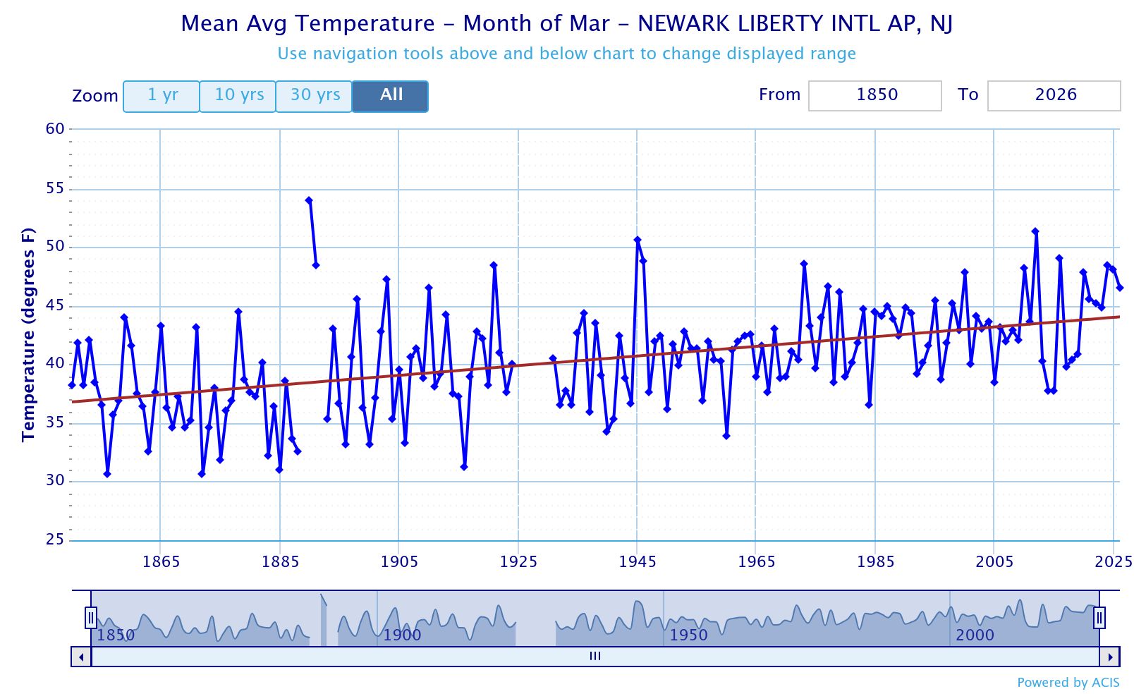
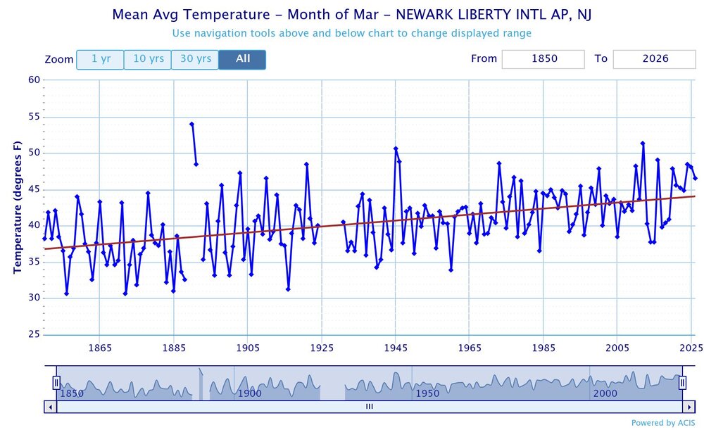
 March is going to be the first widespread AN temperature month for Eastern US cities since September. October and November were NN, and of course, December, January, and February were solidly BN.
 -
Daw Daw Daw
-
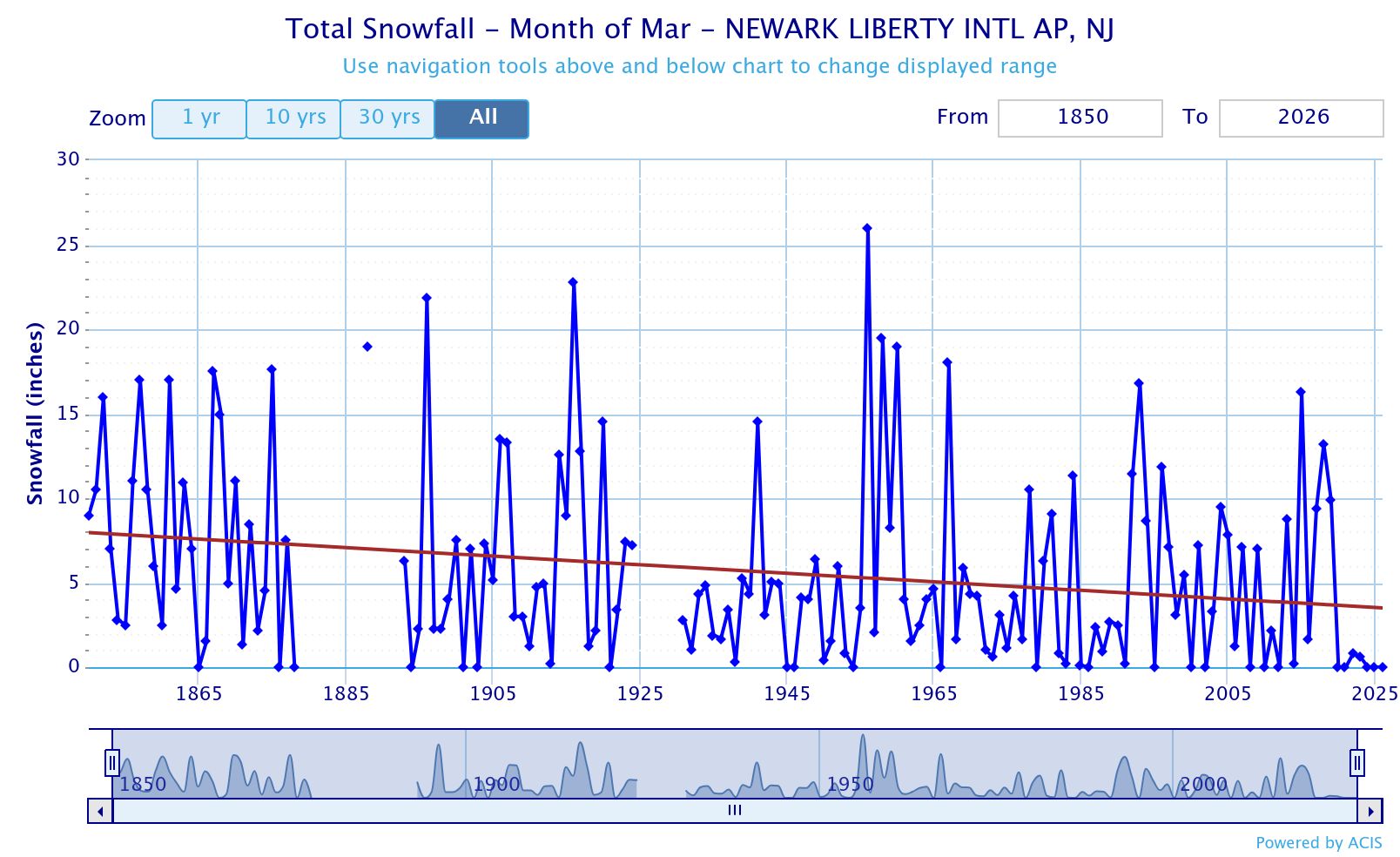
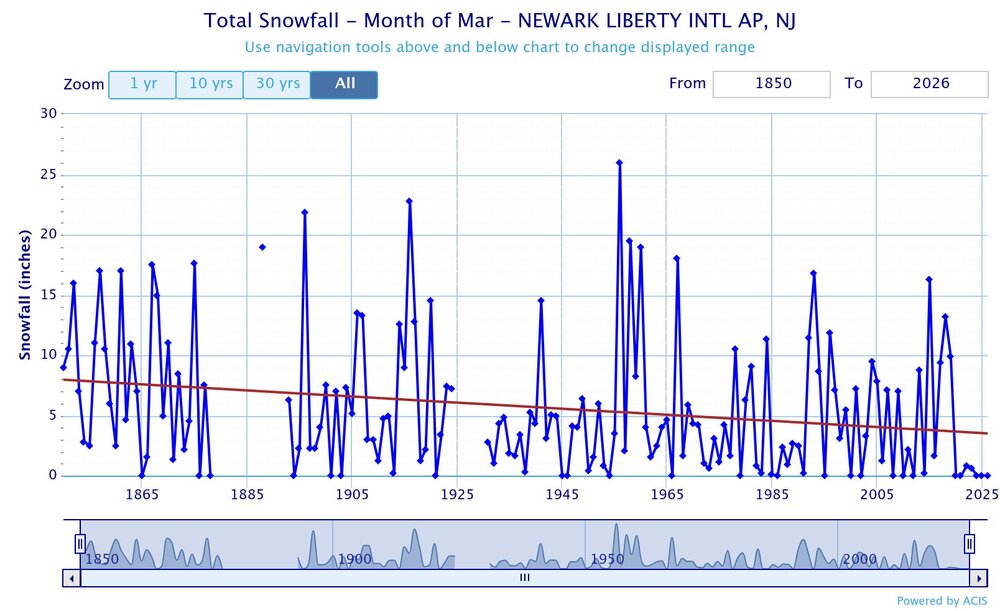
March is becoming too warm for much snow during the 2020s. It will be interesting to see if we can sneak in a snowier bounce back March before the 2020s ends. Even though several spots haven’t seen a 10” event in March since 1993, most would be happy with a nice 1-3” or 2-4” type event.
-
The winds are absurd all the time now. It is what it is.
-
Brunt of the rainfall is focused around the periphery of the ridge the next 5 dys / week.
-
Mar 2012 was +8.7 but never reached 80 . Just consistently warm each day. This month will end around +4.2 in EWR
-
2026-2027 El Nino
PhiEaglesfan712 replied to Stormchaserchuck1's topic in Weather Forecasting and Discussion
Come to think of it, 2015-16 is the only el nino post 2002-03 that is a +PDO. 2004-05 -PDO 2006-07 -PDO 2009-10 neutral PDO (November December -PDO; January February +PDO) 2015-16 +PDO 2018-19 -PDO 2023-24 -PDO -
We should have had a wind warning or something last night but nothing was issued. For about 20 minutes straight my wind averaged over 40MPH with multiple 60+ gusts. Had a max wind gust of 67 around 1:30 this morning.
-
+20 daily dep day coming up, records looks just safe in the big sites EWR, NYC, LGA etc
-
Records: Highs: EWR: 85 (1998) NYC: 86 (1998) LGA: 82 (1998) JFK: 74 (1986) Lows: EWR: 22 (1964) NYC: 14 (1923) LGA: 24 (1964) JFK: 21 (1964) Historical: 1771-72: Washington in the winter of 1771-72 had over 50 inches of snow - much like the snowy winter of 1995-1996 when 40-60 inches of snow fell in the Washington area. (Washington Weather Book 2002 by Ambrose, Henry, Weiss) 1805-06: During the winter of 1805-06 only 4.5 inches of snow fell similar to the winter of 2000-2001. (Washington Weather Book 2002 by Ambrose, Henry, Weiss) 1843: Four feet of snow was still on the ground at Gardiner, ME following the snowiest March on record. 1890 - Saint Louis, MO, received 20 inches of snow in 24 hours. It was the worst snowstorm of record for the St Louis. (David Ludlum) 1892: The “Grim Reaper” at work? An outbreak of significant tornadoes raked parts of TX - OK - KS - NE. Near Wellington, KS, 4 people in a farming family died when a reaper was thrown into their home by an F4 tornado. The same storm injured 13 family members in another home. (Ref. Weather Guide Calendar with Phenomenal Weather Events 2011 Accord Pub. 2010, USA) (David Ludlum) 1907: This month was very warm in Oklahoma City, OK. Many daily records remain on the books, including three daily high temperature records and six daily records for the warmest low temperature. The hottest temperature ever recorded in March also occurred during this year: 97° and the warmest low temperature ever recorded in March: 68°. Overall, the month ranked as the second warmest March ever; with an average temperature of 59.5°, slightly more than nine degrees above normal. (Ref. Wilson Wx. History) 1933: 37 people were killed and 170 were injured as an F4 tornado moved through Jones, Jasper, Clarke counties in Mississippi. (Ref. Wilson Wx. History) 1942: 107 inches of rain fell during the month at Puu Kukui at Maui, Hawaii to set the U.S. record for rainfall in one month. The same place also holds the annual rainfall record for the United States with 578 inches in 1950. 1954 - The temperature at Rio Grande City, TX, hit 108 degrees, which for thirty years was a U.S. record for the month of March. (The Weather Channel) 1959: A round of severe storms caused damage across much of Oklahoma. In Noble and Pawnee Counties, tornadoes caused damage to farms, while in Shawnee, a golf ball sized hailstone knocked one person unconscious. Baseball size hail fell in Thackerville, with some stones as large as 11 to 12 inches in circumference. This created holes in roofs, windshields, and even produced craters in the ground. (Ref. Wilson Wx. History) 1962 - A tornado struck the town of Milton, FL, killing 17 persons and injuring 100 others. It was the worst tornado disaster in Florida history. (David Ludlum) 1973 - A devastating tornado took a nearly continuous 75 mile path through north central Georgia causing more than 113 million dollars damage, the highest total of record for a natural disaster in the state. (The Weather Channel) 1979: The maximum temperature for the date is 85 °F in Washington, DC and also in 1981. (Ref. Washington Weather Records - KDCA) 1981: The maximum temperature for the date is 85 °F in Washington, DC and also in 1979. (Ref. Washington Weather Records - KDCA) 1987 - March went out like a lion in the northeastern U.S. A slow moving storm produced heavy snow in the Lower Great Lakes Region, and heavy rain in New England. Heavy rain and melting snow caused catastrophic flooding along rivers and streams in Maine and New Hampshire. Strong southerly winds ahead of the storm gusted to 62 mph at New York City, and reached 87 mph at Milton MA. (The National Weather Summary) (Storm Data) 1988 - March went out like a lion in eastern Colorado. A winter-like storm produced 42 inches of snow at Lake Isabel, including 20 inches in six hours. Fort Collins reported 15 inches of snow in 24 hours. Winds gusted to 80 mph at Centerville UT. Albuquerque NM received 14 inches of snow. (The National Weather Summary) (Storm Data) 1989 - Afternoon thunderstorms produced severe weather from North Carolina to Pennsylvania. Thunderstorm winds gusted to 76 mph at Cape Henry VA. While squalls blanketed northwest Pennsylvania with up to 9 inches of snow, thunderstorms in eastern Pennsylvania produced golf ball size hail at Avondale. (Storm Data) (The National Weather Summary) 1990 - The month of March went out just as it came in, like a lamb. Marquette MI, which started the month with a record high of 52 degrees, equalled their record for the date with a reading of 62 degrees. (The National Weather Summary) 1991: Anchorage recorded an all time seasonal snowfall total of 145.9 inches. 1996: March ended another month of extreme dryness. The period from July 1995 through March 1996 was the driest period ever at many locations across western Kansas, with records dating back 120 years. The wheat crop was almost completely wiped out by the drought. (Ref. Wilson Wx. History) 1997: During the peak of the storm from about 11 p.m. March 31 to 3 a.m. April 1, snow fell in Boston at an almost unheard-of rate of 3 inches per hour, some of the heaviest Boston had ever seen. Numerous lightning strikes and thunderclaps accompanied the extremely heavy snow, which accumulated one foot (12 inches) in just that four hour period. Moderate to heavy snow continued through midmorning before tapering off. The 25.4 inches that fell at Boston's Logan International Airport was the third-biggest snowstorm in Boston history (biggest in the month of April) behind the North American blizzard of 2003 (27.5 inches ) and the Northeastern United States blizzard of 1978 27.1 inches and made April 1997 the Boston's snowiest April on record (the previous record being a mere 13.3 inches). It also set a record for Boston's greatest April 24-hour snowfall. Parts of New England received 50 to 70 mph wind gusts at the height of the storm. Providence recorded 18 inches of snow which was the fourth greatest on record at the time. Other parts of New England reported more than 30 inches] and up to three feet with Worcester receiving 33 inches, the city's largest snowfall in history. (Ref. The Major Late Season Snowstorm) Ref. (NWS Ranking for Storms between 1956 and 2011) This is the 38th Worst Snowstorm 2006: March 2006 was not only the driest March but also tied the record of the driest month in the last 26 years at Annandale Weather Center with October 2000. No measurable precipitation occurred in Annandale for 18 days from March 3rd through March 20th. This is now the longest period without measurable precipitation since 2001 when the 26-year record was set of 34 days from Oct. 17th - Nov. 19th. (Annandale Weather Center) 2010 - Jacksonville, Florida's, record streak of days with high temperatures below 80 degrees comes to an end at 105 days. It was also Jacksonville's first 80 degree reading of the year. The previous latest first 80 degree day was on March 14, 1978 2010: After three significant low pressure systems drenched the region, Massachusetts, Rhode Island, and New Jersey all measured their wettest March in 116 years. Of the storms striking the Northeast in March, the huge Nor'easter that hammered the region on March 12-14 was the fiercest. Another rainstorm on March 29-31 pushed numerous rivers over their banks in Rhode Island and Massachusetts, resulting in historical flooding across Rhode Island. Residents in East Providence clamored aboard boats to evacuate their homes. Storm total rainfall reached 9.97 inches in Washington County, Rhode Island. The monthly total of 16.34 inches set an all-time monthly record in Providence, Rhode Island, and Boston, Massachusetts, with 14.87 inches, had its soggiest month in 55 years. (Ref. Weatherwise U.S. Weather Highlights of 2010 page 5)
-
2026-2027 El Nino
40/70 Benchmark replied to Stormchaserchuck1's topic in Weather Forecasting and Discussion
Maybe something like this? -
Pope just doing wheelies on his Kawasaki with wine bottles in hand.
-
wtf?
-
I’d also argue 65/25 is worse than 45/40. In the former case the landscape senses the freezing risk at night…
-
Yeah. March sucks. Worst month in the area. It's way worse up in the snowbelt. They'll be 55 one day followed by teens and blizzard conditions. Just like here but more intense. Well.. maybe not. We do go from 85 to snow the next day lol
-
Like coastal wx never seen a picture of Ireland before.
-
It looked like Ireland here in 2009.