All Activity
- Past hour
-
 This is the main show for at least the NW crew. As a note, I’m in Denver so I’d love to see you guys get wedged… just not seeing it.
 -
 No it’s not. Storms rolling thru around 12-1 will wipe out any energy for anything later.
 -
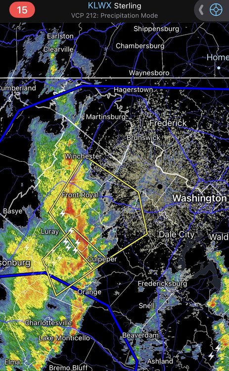
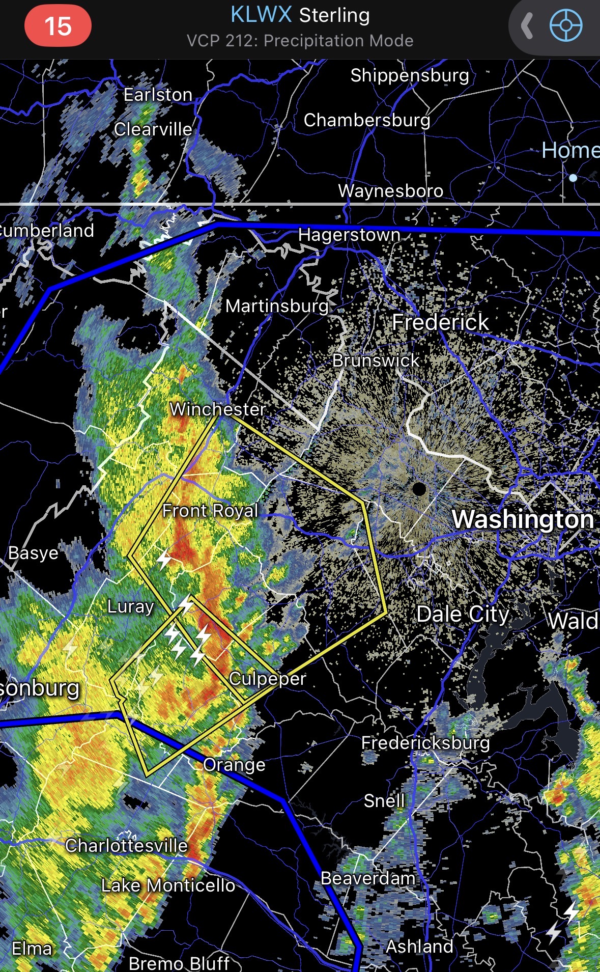
 Tornado warning for culpepper.
 -
 Lost power with first line this morning. In Nelson County. Showers have moved through and clouds are thinning out with some blue sky showing. Gusts were made 40mph range with a little lightning and half inch of rain. .
 -
 Tornado Warning coming out for Rappahannock Co., Fauquier, and Culpeper counties.
 -
 I'm confused. So which is it? A one off HRRR run that shows nothing but a little line later today or this?
- 424 replies
-
- 2
-

-
- severe
- thunderstorms
- (and 1 more)
-
March 21 mean jack shit That date means nothing to physics and celestial mechanics.
-
Band is developing over Alabama. This is going to be some of the heavier snow we have seen in a while. I am looking forward to it. Got my calendar cleared.
-
Look at the 3k
-
How much ice did you get last year, we got about 1.2 - 1.5" imby in last years ice storm.
-
Seems a bit premature…
-
The experts have been wrong before. I’m not seeing it. I wanted to call TSSN the fail mode asshole he can be, but we’re on the same page here.
-
Defintely Best winter in over a decade here.
-
If we getting severe today feel like it’s mostly coming from this line. Let’s see what it does.
-
Warm fronts do this ... WPC evaluates and it seems they maybe just pick a mean position, because there's like these multiple gradient axis ... One extends along the Pike up here... It's 30s and low 40s N of that, and 50s below with more regions S obs in the wind field. Fine... but go down into the Mid Atl and there's another one, where it bounces into the mid 60s. It's like there's multiple warm boundaries in a diffused tapestry and WPC just has a snake there in the midst of it all.
-
Really? It's half over there are 9 days BN on EPS
.thumb.png.f75e0f5520dbf88ecadf79bbdc61caa1.png)
-
10:30 and we all haven’t died yet. Disappointed pretty sure one of the clouds was in the shape of a middle finger as it flew by at about 40mph
- 424 replies
-
- 3
-

-
- severe
- thunderstorms
- (and 1 more)
-
 Hard to say about later but it was always supposed to be multiple rounds with the worst being later tonight.
 -
 If that storm holds, Warrenton through Loudoun County look to take it directly on the chin.
- 424 replies
-
- 1
-
-
- severe
- thunderstorms
- (and 1 more)
-
 How much warmer was it supposed to get anyways? Already in the upper 60s. Sun would help but seems like CAPE might be sufficient already. Also, is the first line going to end up being the main event? Wouldn't be the first time.
 -
13z hrrr essentially shows nothing across Maryland today. Little line of normal storms later.
-
GFS and NAM soundings don't look impressive at all. HRRR is more interesting though.
-
If my Aunt had balls she'd be my uncle.
-
 68/65
68/65


.png.f2948ac623a303aa4d356bf7448a151d.png)


