All Activity
- Past hour
-
Going to be an early one.
-
WB 18Z EPS is actually a tick north compared to 12Z.

-

September 2025 OBS-Discussion centered NYC subforum
jm1220 replied to wdrag's topic in New York City Metro
Of course. Already looks lame coming through central NJ. -

2025-2026 ENSO
michsnowfreak replied to 40/70 Benchmark's topic in Weather Forecasting and Discussion
Two things to comment on this. #1) This is a good example of why I always say...pattern is more concerning than temps for here in terms of snowfall. Despite the bright orange color, the snowfall in those 3 Januaries at Detroit was: 1950- 9.5", 2017- 11.8", 2023- 11.7". The longterm POR avg for Jan snow is 11". #2) it would not be a surprise to me whatsoever to see a very nice winter stretch as well as a shitty stretch....its very common in Nina winters. Always has been and to coin a favorite term on here, in "today's climate", you can even add an extra boost to that volatility. But you should know that anything from that poster is nothing but troll bait, and certainly not a legitimate thought/forecast for the coming winter. -
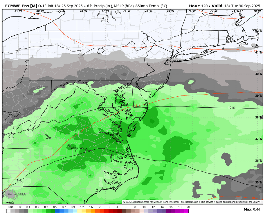
Stalls off SC for several days first...WB 18Z AI.
-
was just about to say that
-
18Z AI solution brings it north by the end of the week.
-
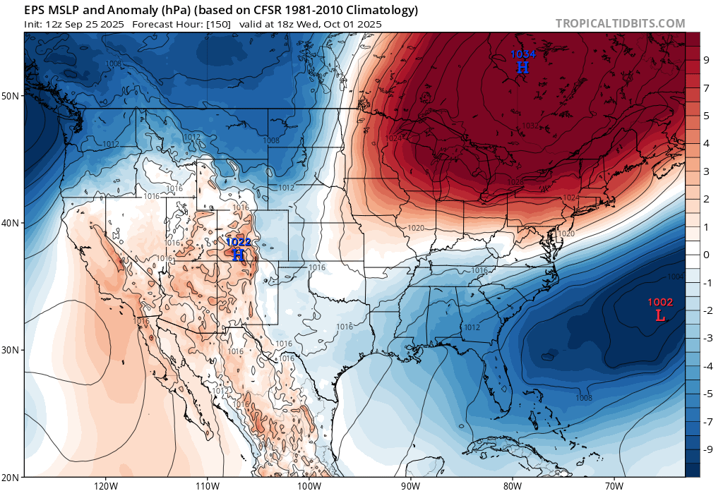
Maybe. This is a pretty anomalous ridge for this time of year I think.
-
Yeah it was going real early down there. I was down in Mt Snow area last week… was shocked. Looked like foliage was going to be past peak by 10/1.
-
I’ve seen this song and dance before. Once a ridge shows up to spoil our precip it’s here to stay. It goes hand in hand with walkbacks begetting further walkbacks.
-

September 2025 OBS-Discussion centered NYC subforum
Picard replied to wdrag's topic in New York City Metro
The line passed through here and was a nothing burger. Picked up another 0.08" to bring the two day total since Tuesday evening to 0.55". The line is blossoming a bit down by Philly but I think it's over with in these parts for a while. -
Climate change is real, and there are certainly risks that come along with it. That being said, fear-mongering and politicization of climate change is also very real. Both things can be true - and don't trust anyone from either "side" who speaks in certainties.
-
I'm still a bit skeptical of such a strong ridge, but if that is the case we will need to watch if future Imelda is able to get back offshore. If so, the guidance seems to believe some sort of regeneration is possible, and with that ridge rolling east that would probably lead to something running up the coast either inland or just offshore. Fantasy range but something to monitor.
-

September 2025 OBS-Discussion centered NYC subforum
qg_omega replied to wdrag's topic in New York City Metro
Crazy bust -

Invest 94L—80% 2 day and 90% seven day odds of development
GaWx replied to WxWatcher007's topic in Tropical Headquarters
The best bet for the SE to avoid a hit and the potential flooding catastrophe would be if 94L were to move away from there more slowly than the model consensus and let Humberto get to a higher latitude than it. Also, the same would probably be the case if Humberto were to move more quickly. Then hopefully Humberto would pull 94L away. -

The "is it ever going to rain again?" discussion.
JenkinsJinkies replied to JenkinsJinkies's topic in Mid Atlantic
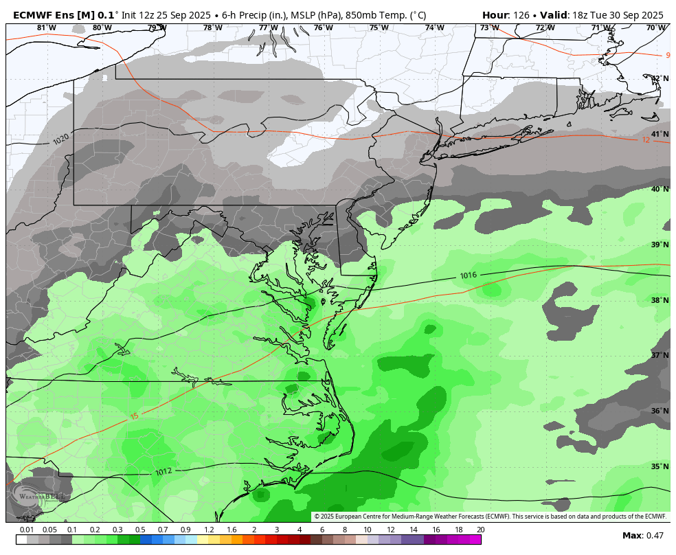
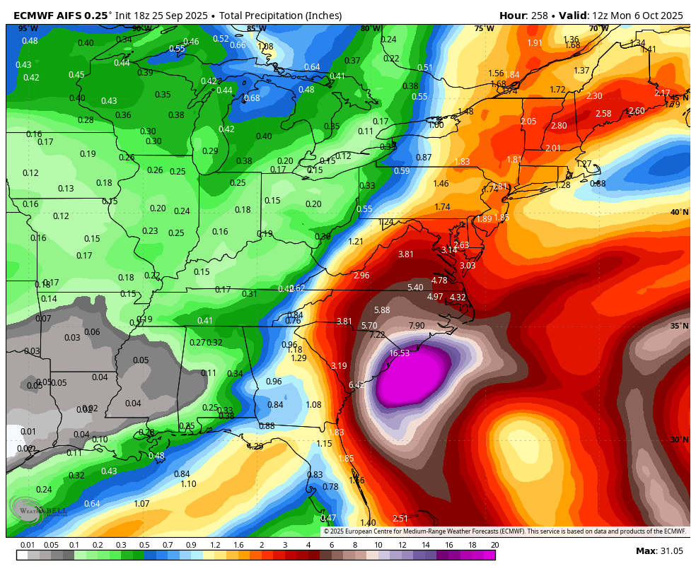
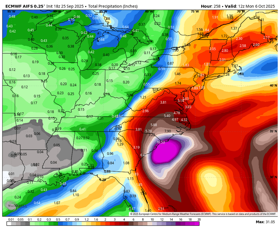
Once again the models give us a huge rain event only to walk it back to practically nothing north of Richmond. What was once a 5 inch even is now an event where we’ll be lucky to get half an inch. I’m willing to bet this is just the start and the walk backs will continue throughout the next two days. When is it going to be our turn?
-
Potential winter tier bust imminent
-
In case you missed it and are interested in the AmericanWx Ryder Cup contest (four are in it so far), here’s the link (deadline 7AM tomorrow):
-
Will we ever get a big rain again?
-
If it were winter...
-

Invest 94L—80% 2 day and 90% seven day odds of development
BooneWX replied to WxWatcher007's topic in Tropical Headquarters
Local western NC talk here: a lot to track and a lot to determine, but if the circulation meanders into SC, it’s another terrible scenario for an area still reeling from Helene. Easterly, upslope flow and a steady fetch of moisture from the Atlantic…not good. We’ve luckily had very dry antecedent conditions but that can change rapidly with plenty of convective activity expected ahead of the circulation. -
 94L isn't going to do anything until whatever circulation that is there, clears Hispaniola.
 -
That map makes me livid
-
 Headline is so irresponsible and hype casting. Why even post that here?
 -
A literal wall of HP. Good news is we will get some cooler/less humid air for at least a few days for the beginning of the month.