All Activity
- Past hour
-

Central PA Summer 2025
Mount Joy Snowman replied to Voyager's topic in Upstate New York/Pennsylvania
Low of 72 with no rain, thankfully. Spent last evening helping a buddy cleanup his property. Now we see what fun today brings. -
Yeah when I drove by yesterday and saw the clouds and the way the sun was highlighting everything I was like I have to turn around and get that shot lol.
-

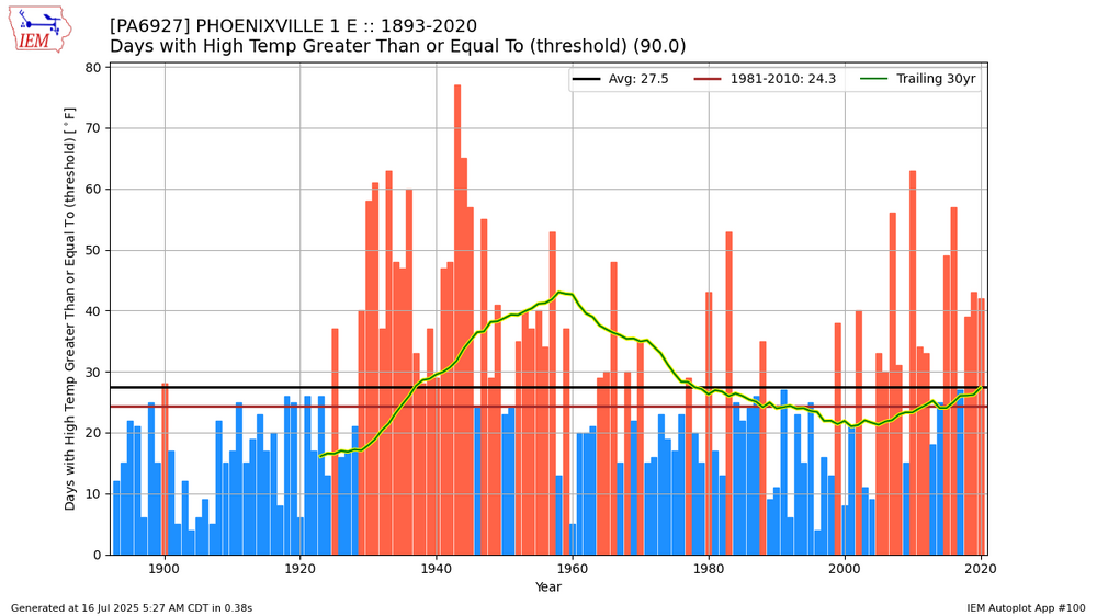
Chester County PA - Analytical Battle of Actual vs. Altered Climate Data
chubbs replied to ChescoWx's topic in Climate Change
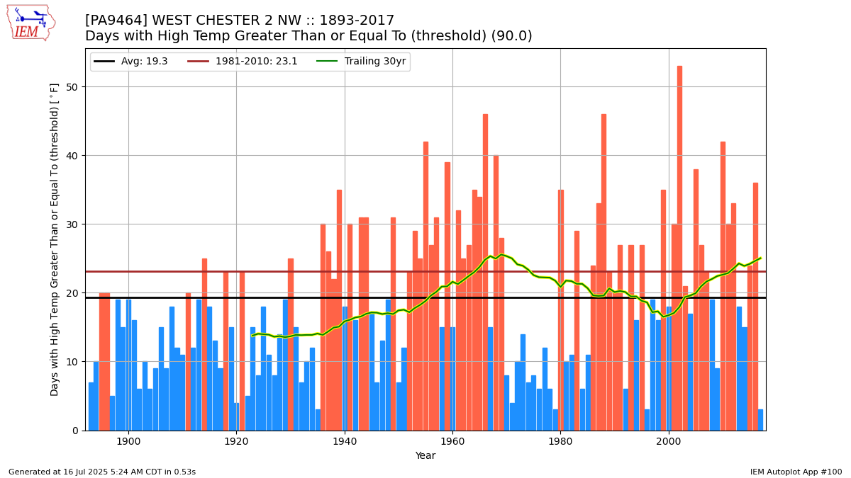
Sure sign of local hot weather, when you are making bogus claims about 90F days. If you want to look at long-term trends you need to have a consistent station population. Instead you are making wholesale changes from a warmer to cooler station population. We have two stations with long-term data. Neither show a long-term decrease in 90F days. Note that these stations are biased due to station changes: West Chester cooled by roughly 2F in 1970, while Phoenixville ran hot in the 1930s-50s and cool in the 1990s. So if anything these charts underestimate the increase in local 90F days in recent decades.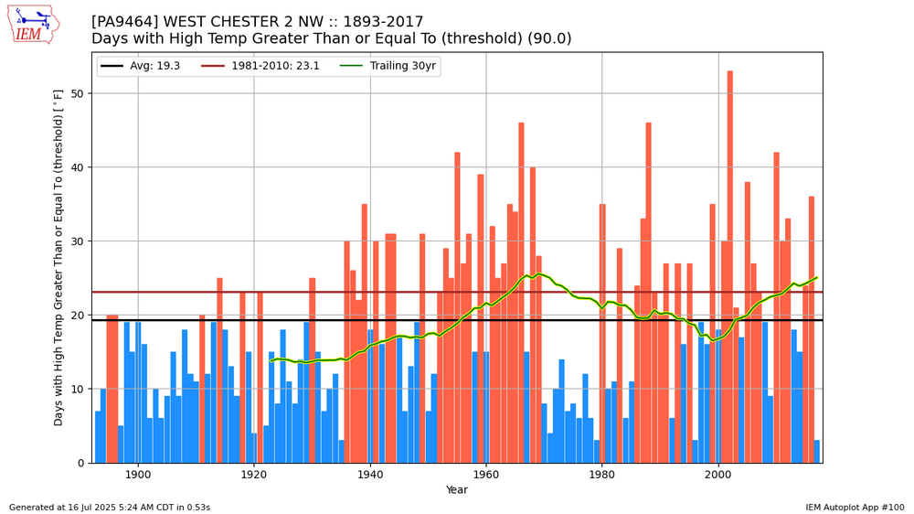
-

July 2025 Obs/Disco ... possible historic month for heat
dendrite replied to Typhoon Tip's topic in New England
The multiple fronts modeled in the LR are cute, but we need to get them under d3-5 first. -

July 2025 Obs/Disco ... possible historic month for heat
UnitedWx replied to Typhoon Tip's topic in New England
Heavy dews this A.M. It's been so moist in some areas you can smell, and nearly taste the mold growth. This is the first time I can remember needing to restart my allergy meds this time of year -
Whose going to be the first to hit 35" since May 1st? Maybe we should do a contest. Sent from my SM-G970U1 using Tapatalk
-

July 2025 Discussion-OBS - seasonable summer variability
JustinRP37 replied to wdrag's topic in New York City Metro
I am thoroughly impressed with the humidity this summer. At least the condensate lines won’t have as much trouble since they are flowing like a faucet! No chance for the water to stagnate! But our lab is still reporting very high tick activity. We should be getting out of peak nymph season before the larvae come out in August. The good thing about larvae is that they typically don’t carry disease since they haven’t fed on anything yet. I used to consider winter and summer as tied for my favorite season, but I am starting to enjoy winter the most. I went outside to watch the fireflies last night for 5 minutes and received over 5 mosquito bites. Summer is great though when you don’t have to work and are in the water. -
July 2025 Obs/Disco ... possible historic month for heat
dendrite replied to Typhoon Tip's topic in New England
MAV has big heat in the NNE valleys today.
-

July 2025 Obs/Disco ... possible historic month for heat
ineedsnow replied to Typhoon Tip's topic in New England
Naw change is coming.. a bit later than I thought but it is -
Hazardous Weather Outlook National Weather Service State College PA 446 AM EDT Wed Jul 16 2025 PAZ004>006-010>012-017>019-024>028-033-034-037-041-042-045-046- 049>053-170900- Warren-McKean-Potter-Elk-Cameron-Northern Clinton-Clearfield- Northern Centre-Southern Centre-Cambria-Blair-Huntingdon-Mifflin- Juniata-Somerset-Bedford-Tioga-Northern Lycoming-Sullivan- Southern Clinton-Southern Lycoming-Union-Snyder-Montour- Northumberland-Columbia- 446 AM EDT Wed Jul 16 2025 This Hazardous Weather Outlook is for central Pennsylvania. .DAY ONE...Today and tonight. Showers and thunderstorms this afternoon and evening may contain torrential downpours, which could lead to isolated flooding issues. Please monitor NWS products and local media sources for any possible watches or warnings later today. .DAYS TWO THROUGH SEVEN...Thursday through Tuesday. The probability for widespread hazardous weather is low. More showers and thunderstorms are anticipated on Thursday. Thunderstorms could contain isolated damaging wind gusts, hail, and heavy downpours. .SPOTTER INFORMATION STATEMENT... Spotters are encouraged to report significant hazardous weather. $$ Hazardous Weather Outlook National Weather Service State College PA 446 AM EDT Wed Jul 16 2025 PAZ035-036-056>059-063>066-170900- Fulton-Franklin-Perry-Dauphin-Schuylkill-Lebanon-Cumberland-Adams- York-Lancaster- 446 AM EDT Wed Jul 16 2025 This Hazardous Weather Outlook is for central Pennsylvania. .DAY ONE...Today and tonight. Showers and thunderstorms this afternoon and evening may contain torrential downpours, which could lead to isolated flooding issues. Please monitor NWS products and local media sources for any possible watches or warnings later today. .DAYS TWO THROUGH SEVEN...Thursday through Tuesday. The probability for widespread hazardous weather is low. More showers and thunderstorms are anticipated on Thursday. Thunderstorms could contain isolated damaging wind gusts, hail, and heavy downpours. Hot, humid conditions are also expected Thursday afternoon, with heat index values possibly nearing 100 degrees. Please monitor NWS forecasts and products, as well as local media sources, for any possible Heat Advisories. .SPOTTER INFORMATION STATEMENT... Spotters are encouraged to report significant hazardous weather. $$
-
July 2025 Obs/Disco ... possible historic month for heat
dendrite replied to Typhoon Tip's topic in New England
Definite boundary from NW MA to the NH seacoast this morning. Just means we’ll be hotter today.
-

July 2025 Obs/Disco ... possible historic month for heat
Damage In Tolland replied to Typhoon Tip's topic in New England
From middle of next week on it will be just like it’s been well into Augdewst . It’s on all ensembles . HHH look -
-
I plant a lot of lantanas for annuals since summers are so arid here. I can't believe we are looking at no rain this week after what it looked like a few days ago. My grass has shut down.
-

July 2025 Obs/Disco ... possible historic month for heat
512high replied to Typhoon Tip's topic in New England
67 for the low at my house, current 70/68 -
I can see how we can go boom today with the trigger still back in Ohio. The atmosphere sits all day in its cauldron of soup bubbling up till trigger swings through unleashes it's built up potential energy mostly through torrents of soup. Sent from my SM-G970U1 using Tapatalk
-
July 2025 Obs/Disco ... possible historic month for heat
ineedsnow replied to Typhoon Tip's topic in New England
After that midweek period we back down that weekend hope it holds.. atleast it won't be anything like it's been.. the last few weeks have been shit.. GFS out to August 1st now it's coming and almost time to put this crap behind us -

July 2025 Obs/Disco ... possible historic month for heat
CoastalWx replied to Typhoon Tip's topic in New England
The steam is back Sunday so just Saturday where it’s less humid. But early next week the humidity will be down before returning mid week. -

July 2025 Obs/Disco ... possible historic month for heat
kdxken replied to Typhoon Tip's topic in New England
Green has never looked so good.
-

July 2025 Discussion-OBS - seasonable summer variability
wdrag replied to wdrag's topic in New York City Metro
No thread for this afternoon-Thursday activity. Small chance isolated 4+ along the southern edge of NYC subforum (I-195) but not threading. Could be isolated severe per SPC. My main concern is Sunday...combined period of excessive rain and possibly two separate episodes of severe (warm front early morning and cold front in the afternoon). SVR not currently outlooked in the northeast but I think it will be in a day or two. EPS combo plot as seen on Pivotal is of interest. -
July 2025 Obs/Disco ... possible historic month for heat
kdxken replied to Typhoon Tip's topic in New England
We can only dream of it here. Thank Jeebus it's within sight. .SYNOPSIS... Heat and humidity peak today but lasts into Thursday. A cold front will bring showers and thunderstorms Thursday before relief from the heat arrives this weekend. Drier and more seasonable weather is ahead next week -
Cold-neutral at the very least is guaranteed and a weak La Niña is looking more and more likely by the day. IMO a warm to very warm met fall (Sept, Oct, Nov) is a definite possibility for the reasons you stated. I also think there’s a dry risk to fall as well
-
I saw the OKX update with the 6+ amounts, many via CoCoRaHs. Thank you. WXUNDERGROUND amounts like my AWN sensor are not qc'd and overall can run a little high in the intense rainfall situations...(stratus plastic is my qc) BUT wxunderground platforms are very good data points that I think warrant consideration by all-especially searching for wx related problems.
-
July 2025 Obs/Disco ... possible historic month for heat
dendrite replied to Typhoon Tip's topic in New England
62.5° Cooler morning. -
July 2025 Obs/Disco ... possible historic month for heat
dendrite replied to Typhoon Tip's topic in New England
I think most of the egg cases are from the chinese mantis though…so you just need to be sure about what you’re getting.