All Activity
- Past hour
-
I love Snow more than anyone, but one of the worst things you can do is try to pull for it, even in the face of uncertainty. I just try to give my insight and try not to be biased.
-
 Months of work to get a normal to below normal winter and we're could lose it in the last two weeks of winter.
 -

Is we back? February discussion thread
Damage In Tolland replied to mahk_webstah's topic in New England
Icon EPS! -
If we're talking geo-engineering for more snow then I think we should mandate people replacing furnaces with heat-pumps. Make it hot inside by extracting outdoor heat. Imagine every house in DC and Baltimore running one of those in winter. Big office buildings too. We'd get an urban cool island, it'd be snowing in downtown Baltimore rain in Towson
-
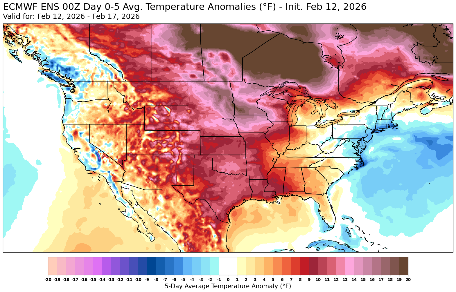
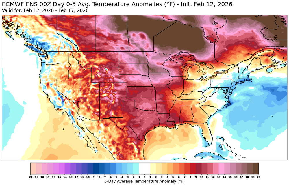
Even with the big warm up across North America the next few weeks, the Northeast is still only getting back closer to average.
-
Now we’re getting big picturesque dendrites. Fantastic
-

Pittsburgh/Western PA WINTER ‘25/‘26
TheClimateChanger replied to Burghblizz's topic in Upstate New York/Pennsylvania
Current 25-year average for March is currently 5.9": -

February 2026 OBS & Discussion
PhiEaglesfan712 replied to Stormlover74's topic in New York City Metro
Those are exactly my thoughts for the rest of the month, though I'm not sure if it rains 2/19-20. It does turn warm to begin March (with us entering MJO Phase 6), and we should get our first 60+ during the first week of March. -
Yes I never look at 5H just a kid weenie.
-
With colder than normal Atlantic waters it could be especially bad this year...pray for a west wind.
-
Dep through the 11th EWR: -9.2 (0.02) NYC: -10 (0.08) LGA: -9.8 (0.03) JFK: -9.8 (0.01)
-
Fair enough. Thanks for the insight. I m sure we play with fire, but it’s worth it now as we head towards the last quarter of the season.
-
Records: Highs: EWR: 70 (1999) NYC: 62 (2018) LGA: 63 (2018) JFK: 61 (2022) Lows: EWR: -1 (1979) NYC: -2 (1914) LGA: 4 (1979) JFK: 4 (1979) Historical: 1784: Ice floes were spotted in the Gulf of Mexico after passing out the Mississippi River in February 1784. Ice blocked the river in New Orleans, Louisiana. The ice in New Orleans is one of two times that this occurred during the Great Arctic Outbreak of 1899. The eruption of Laki in Iceland from June 8, 1783, through February 7, 1784, is the likely cause for the severe winter of 1783 - 1784. 1899 - Texas and the eastern plains experienced their coldest morning of modern record. The mercury dipped to 8 degrees below zero at Fort Worth TX, and to 22 degrees below zero at Kansas City MO. The temperature at Camp Clarke NE plunged to 47 degrees below zero to establish a record for the state. In the eastern U.S., Washington D.C. hit 15 degrees below zero, while Charleston SC received a record four inches of snow. (David Ludlum) 1899: The bitter cold outbreak of February 1899 continued across the southern Plains, Texas, and the Deep South. The mercury dipped to 8 degrees below zero at Fort Worth, Texas, and 22 degrees below zero at Kansas City, Missouri. Nebraska’s temperature at Camp Clarke plunged to 47 degrees below zero to establish a state record. The all-time record low for Oklahoma City was set when the temperature fell to a frigid 17 degrees below zero, breaking the previous record low of 12 below zero, set on the previous day. Washington D.C. hit 15 degrees below zero, while Charleston, SC, received a record four inches of snow. Snow was also reported in Fort Myers, Tampa, and Tallahassee in Florida. 1958 - Snow blanketed northern Florida, with Tallahassee reporting a record 2.8 inches. A ship in the Gulf of Mexico, 25 miles south of Fort Morgan AL, reported zero visibility in heavy snow on the afternoon of the 12th. (12th-13th) (The Weather Channel) 1960 - A snowstorm in the Deep South produced more than a foot of snow in Louisiana, Mississippi and Alabama. (David Ludlum) 1987 - A storm in the eastern U.S. produced high winds from North Carolina to Maine. A storm in the western U.S. produced up to thirty inches of snow in the Sierra Nevada Range of California. (The National Weather Summary) (Storm Data) 1988 - A classic "nor'easter" formed off the Carolina coast and intensified as it moved up the Atlantic coast bringing heavy snow to the northeastern U.S. Totals ranged up to 26 inches at Camden NY and Chester MA. Arctic cold gripped the north central U.S. Duluth MN was the cold spot in the nation with a low of 32 degrees below zero. (The National Weather Summary) (Storm Data) 1989 - Unseasonably mild weather prevailed across Alaska. Morning lows of 29 degrees at Anchorage and 31 degrees at Fairbanks were actually warmer than those in northern Florida. (The National Weather Summary) 1990 - Strong southerly winds ahead of an arctic cold front pushed temperatures into the 70s as far north as Iowa and Nebraska. Twenty-one cities in the central U.S., seven in Iowa, reported record high temperatures for the date. Lincoln NE reported a record high of 73 degrees, and the afternoon high of 59 degrees at Minneapolis MN smashed their previous record for the date by twelve degrees. Springfield IL reported a record forty-eight consecutive days with above normal temperatures. (The National Weather Summary) 2006 - An intense snow squall off of Lake Michigan cuts visibility to zero along a section of US 31. The resulting whiteout causes 96 cars to pile up. 25 were injured. 2017: There was an imminent failure of the auxiliary spillway on the Oroville Dam in California.
-
I think so!!
-
I’m not frustrated about Monday at all. Is it disappointing, sure… But I’ve been against this for days. I do get a little annoyed when people just post weenie crap on here and just don’t look at any models or anything like that. I spend a lot of time looking at stuff and giving my thoughts here. Do I joke and mess around, sure but I think we all doing some shape or form. You’ll never see me insult anyone or anything like that.
-
February 2026 OBS & Discussion
PhiEaglesfan712 replied to Stormlover74's topic in New York City Metro
Historical snow seasons have ended early. 2009-10 in Baltimore or DC is a perfect example. Baltimore had 80 inches of snow at this point in 2010 following Snowmageddon, and it didn't really snow again after that. [In fact, it reached 90 during the first week of April.] For NYC, that was 2010-11. It didn't stop snowing, but there was a huge drop off after January. Only 5.8 inches of snow fell after January (with only 4.2 inches after this point). -
Is we back? February discussion thread
Damage In Tolland replied to mahk_webstah's topic in New England
It’s coming? -
Until then, we probably have a couple of shots of some sort of overrunning, but again we’re really close to either getting good snow or tanning.
-
But you let emotion cloud your judgement too much lately. It’s blatantly obvious. I wasn’t big on the storm Monday either…I doubted it. And agreed with your idea of it wasn’t a good set up. But please Take this constructively….you’re a smart MET. You know your stuff. Folks look to you for some insight. But lately, when a potential misses…you start with the nonsense of ending things. And it’s constant. Whether you’re doing that to get folks upset, or it’s your COPING Mechanism, the signs are blatantly obvious. Kevin said the same thing to you a couple mornings ago. And I actually stayed out of it. But he was right. I know you feel like what can a non MET show me….but believe me it’s clear. So just take that as something constructive. And before you say you’re just keeping it real…it’s beyond that now. I appreciate real, I think most of us do. But it’s abundantly clear that your frustration gets the best of you a lot lately. Not trying to be a jerk, BUT just keeping it “Real” as you like to say, on how it looks from the outside looking in. Stop being the angry frustrated Scott, and go back to the one we used to know.
-
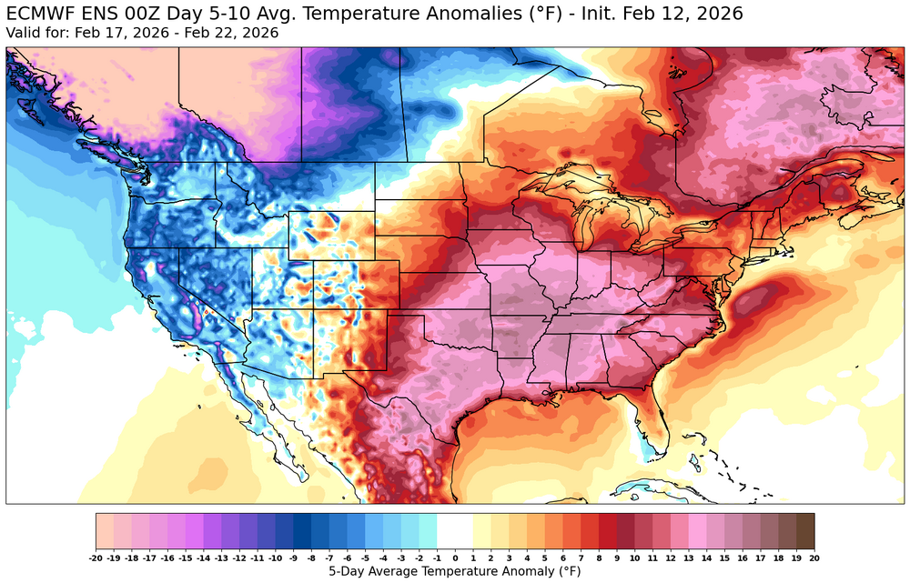
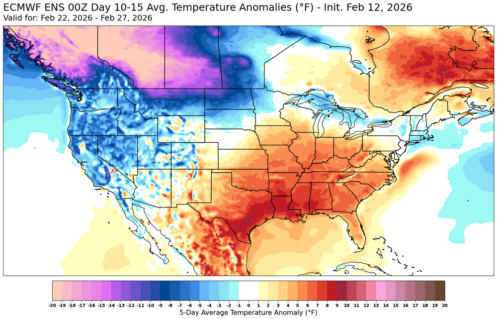
I think later in the 11 to 15 day what you’d wanna see is as that -WPO ridge retros perhaps we can try to pop somewhat of a +PNA. If you can do that, you’ll limit the amount of Pacific air going into Canada and obviously you’d have a better chance of something here late month or early March. My point in all this is that it looks a little tenuous to me that’s all.
-
Flurries in Springfield
-
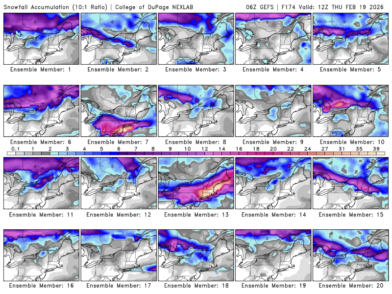
I'll take number 13
-
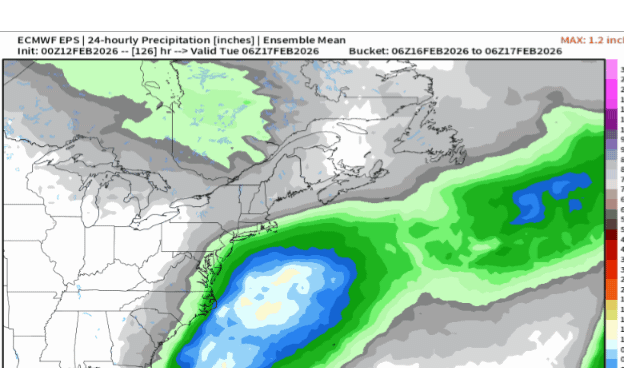
35 / 18 - Today / tomorrow should be the coldest days of the next 10. Overall dry (outside next Thu-Fri) as the storm misses 2/15. Overall warmer above avg 2/14 - 2/20 with the first shot at 50+ between 2/17 - 2/18. 2/12- 2/13 : near to below avg 2/13 - 2/20 : Moderation to / above avg first 50+ possible for some TueWed next week, Rain 2/19-20 2/21 : Moderation back colder 2/22 - beyond : perhaps more activity to track with an overall colder close to the month - at this point it doesnt look significantly strong cold.
-
Or we’ll have foggy drizzly crap in the 40s on easterly winds. Misery but without the benefit of rain for the water table/reservoirs.
-
It was 0 at 0z