All Activity
- Past hour
-
I love how he uses AVP to make that point. AVP is not a spot that hits 90 particularly often (I don't believe). If AVP is into the lower 90's then the hottest locations within the region are into the mid to upper 90's and EWR is probably 100. AVP is our ORH.
-
Finally something worthwhile to track
-
I dunno, these setups don't scream good radiational cooling. But I guess if touching like 67-70F at night makes the cut, then yeah, could be worse. Dews could be in the 70s, true. Instead of 65-70F.
-
Not much humidity , good radiational cooling with temperatures in the '60s at night. Could be worse...
-
LORENZO INNIT I’m thinking she might turn into the Carolinas last minute but idk lad
-
I'm watching that 60W/20N spot. Storms that pass north of it stay out to sea almost all the time, barring some major H5 +anomaly over the top.
-
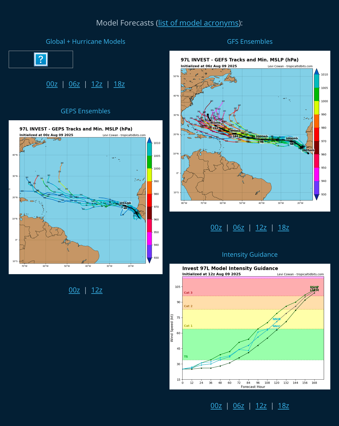
97LLLLLL BAM BAM BAM SCORE SOME FAKKIN GOALS LASS Invest 97LAs of 12:00 UTC Aug 09, 2025: Location: 10.1°N 17.0°WMaximum Winds: 25 kt Gusts: N/AMinimum Central Pressure: 1006 mbEnvironmental Pressure: N/ARadius of Circulation: N/ARadius of Maximum wind: 90 nm
-
Real nice Tpalm5. I’ll be bookmarking this station also!
-
Glad to be escaping the heat tomorrow to head to Texas. Looking forward to the recurving whiff to kick up some surf. GTG at Weekapaug?
-
The heat is back back again The heat is back tell that ACATT the heat is back, the heat is back, the heat is back
-
 56.3 here last night.
 -
Well we shall see if the prophet is right. Now designated as Invest 97L.
-
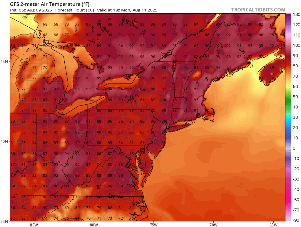
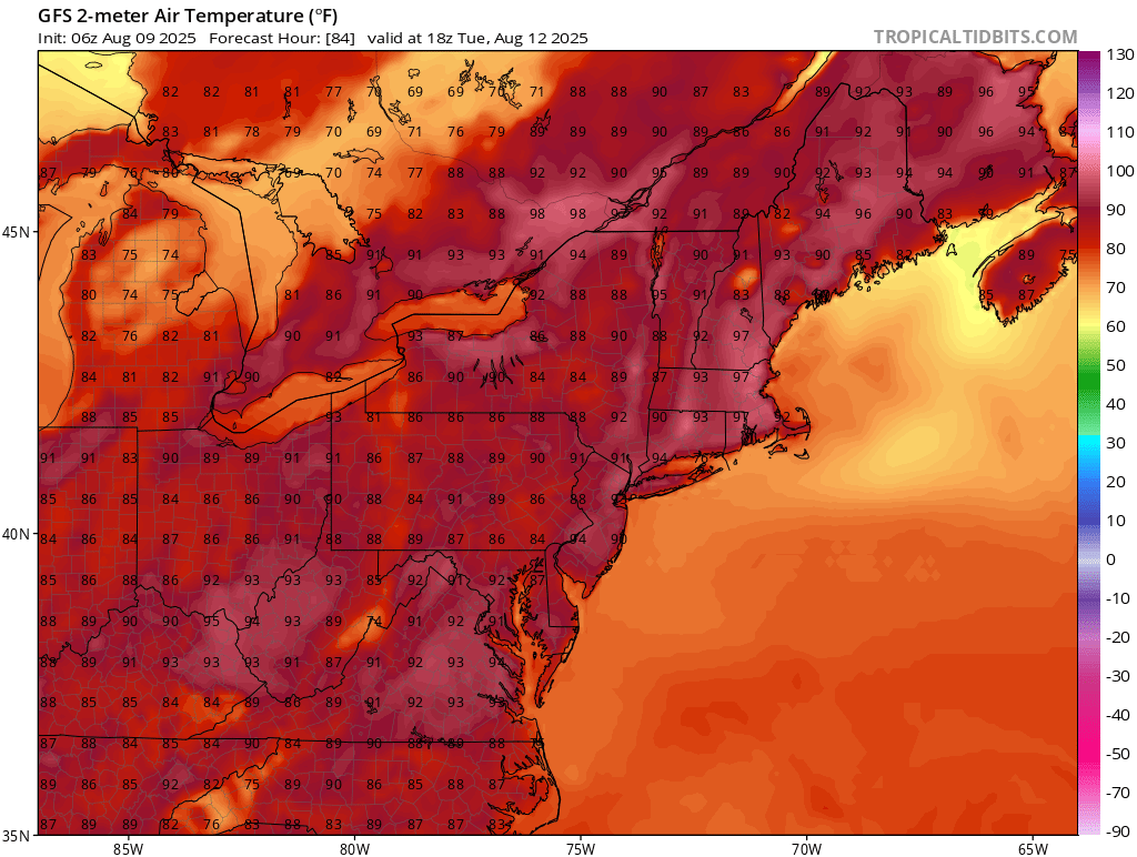
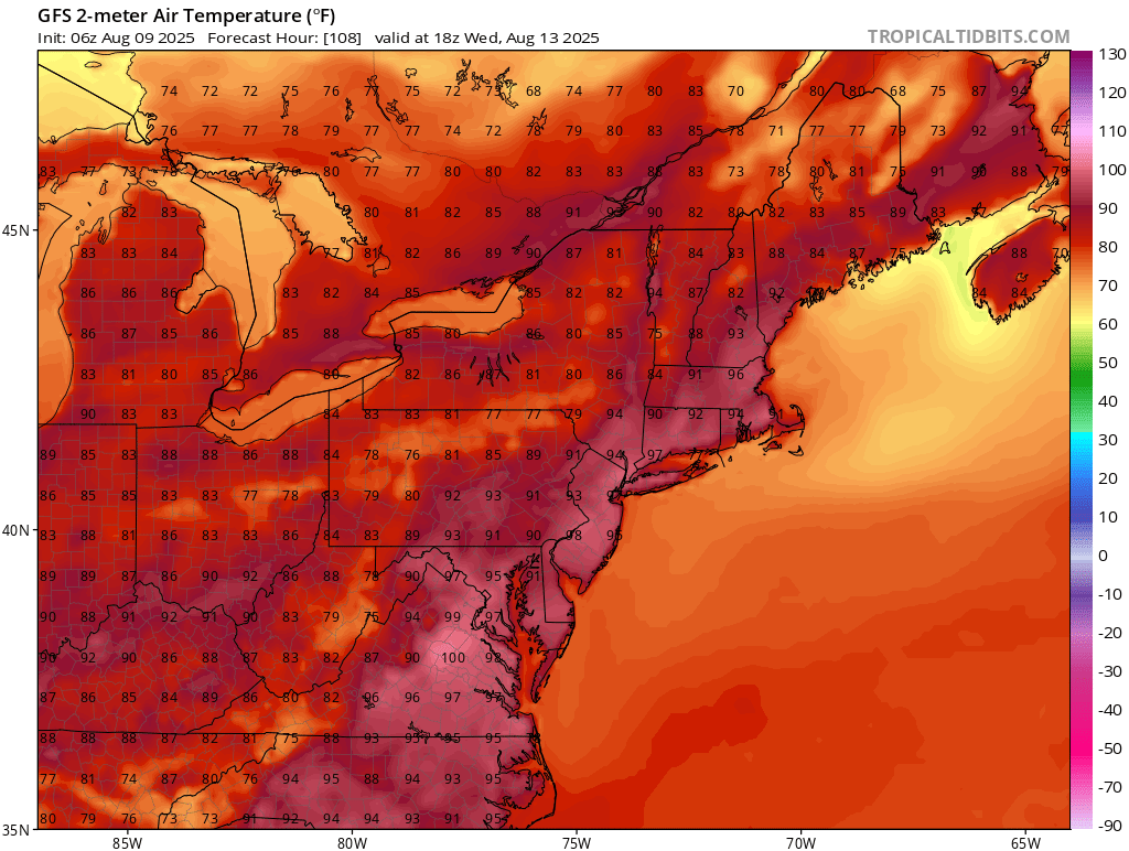
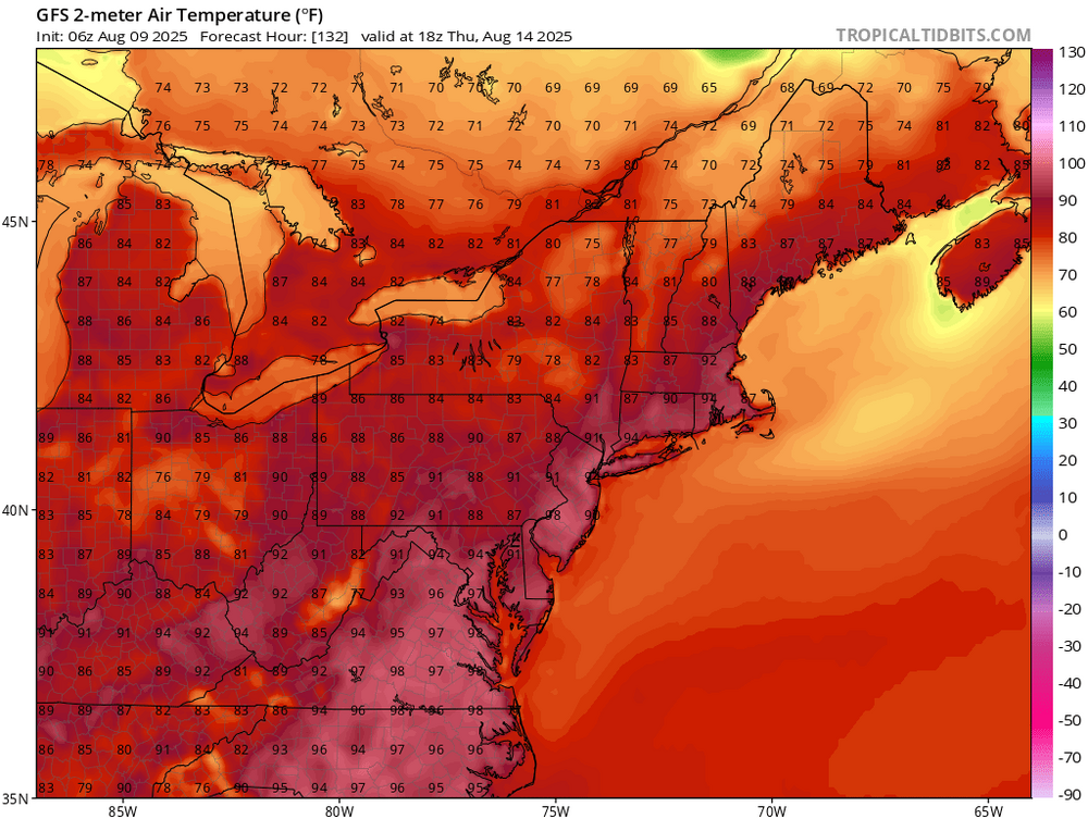
That's a solid heater right there on the GFS... Monday through Thursday 18z temps.


-
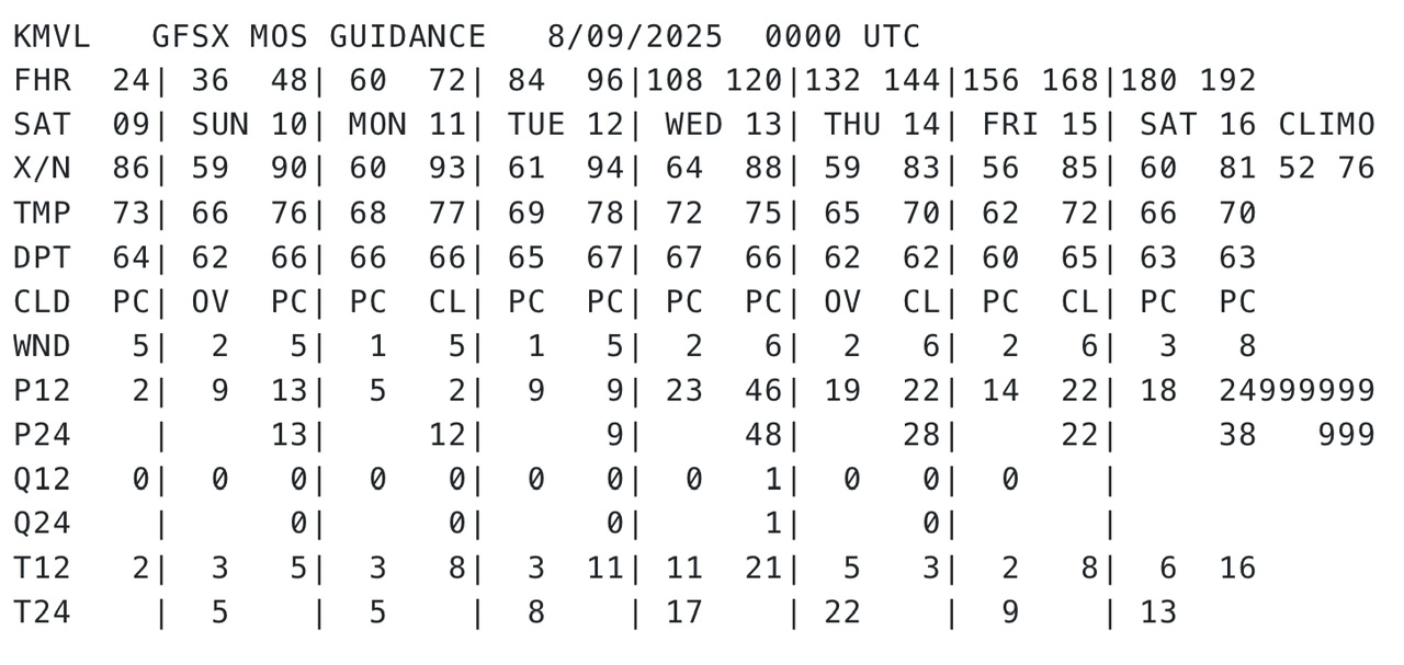
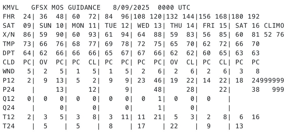
that "climo" of 76/52... and it's rattling off 86F, 90F, 93F, 94F, 88F, 83F, 85F, 81F. Climo drops 2F in highs over the next week... from 78F to 76F. Good grief those departures are going to sky rocket in flight.
-
Yea weenie land. Whats the lotto tickets ?
-

2025 Atlantic Hurricane Season
BarryStantonGBP replied to BarryStantonGBP's topic in Tropical Headquarters
AFRICAAAAA BAM BAM BAM SCORE SAM FAKKIN GOALS -
OI LADS LEZAK HAS SPOKEN GTFIH BAM BAM BAM LADS
- Today
-
Let’s break some records.
-
Early shot of BN temps always a good sign imho. Not because it guarantees a decent/cold winter, more because decent/cold winters often have late summer/early fall cool shots.
-
 we need a deep trough to our west to bring canes up the coast. i think se/gulf is more likely
 -
I was looking up ENSO years and not surprisingly, I've started finding conflicting data. The PSL NOAA site now says that 1995-96 was ENSO neutral. I've always known it to be a Nina. It has several other conflicting instances as well.
-
Pretty impressive that not a single day in the next 7 up here has a high temperature forecast to be less than +5 above normal. Normal is 78F... "coldest" NWS max is 83F next Thursday lol. A couple 92s on Monday and Tuesday. Normal low is 54F and there appears to be nothing lower than 61F, ha. Positive departures are going to escalate rapidly.
-
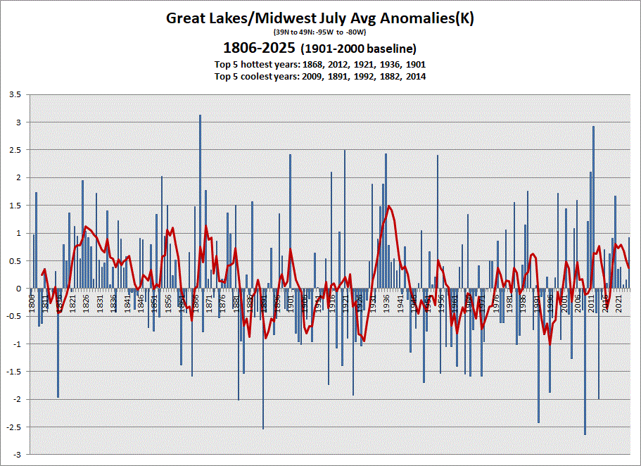
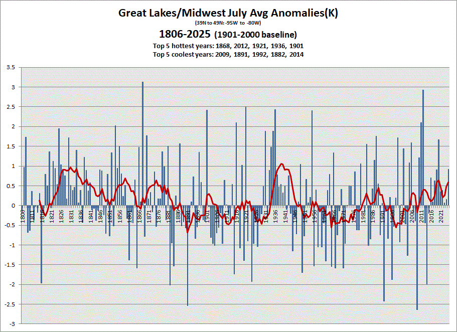
Early data in for July. Warmer one in the books after a string of near avg in recent years. 5 & 10 yr trend charts shown respectively.