All Activity
- Past hour
-

September 2025 OBS-Discussion centered NYC subforum
winterwarlock replied to wdrag's topic in New York City Metro
76/45 my splits both Monday and Tuesday -
normal to slightly above for you on that map meh
- Yesterday
-
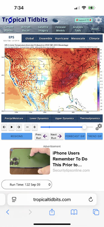
I would lean normal to a bit AN for the next two weeks. More favoring AN. Not hot though. +1.5 or so.
-
https://x.com/bennollweather/status/1965519169329529233?s=46&t=dhcbvkjmRcyBVQtDxJ3lRg
-
ya looks like great beach and pool weather..

-
I use an ensemble and Climo knowledge approach . It’s a milder pattern next 2+ weeks . Op runs are 100% useless
-

September 2025 OBS-Discussion centered NYC subforum
psv88 replied to wdrag's topic in New York City Metro
77 today -
Let’s get September AN and keep that into next summer.
-
Deep Fall
-
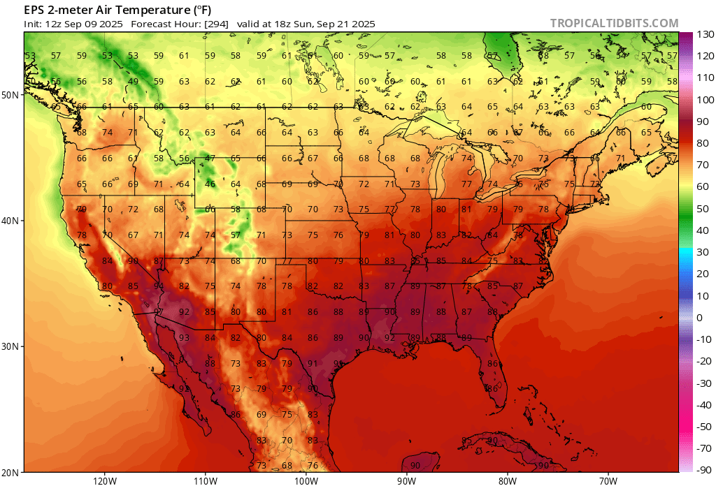
The extended is warm on the EPS. Some drinking heavily.
-
I had 86 and some areas were 86-88 I believe.
-
yep, Washing DC hit 91 on saturday
-
There is zero cold in sight.
-
Thursday will be close to 80 inland
-
Did anyone hit 85-90 this past weekend as some forecast? 80 here but I tend to run cool.
-
Lots of 40s at night
-
Euro has lots of 60's for you next week for highs. Many days hovering around 70 also. Didn't see anything approaching 80. You must be looking at the GFS.
-
I got up to 80 today. A 31 degree difference from this am.
-

2025-2026 Fall/Winter Mountain Thread
Maggie Valley Steve replied to Buckethead's topic in Southeastern States
I had a high today of 68 after a low of 46. We're getting a lot of clouds throughout the day which surprised me. Lots of hay fields being cut around the area. I see some of the models are showing a possibility of another strong front in about 8 to 10 days. -
It’s lots of 70’s to near 80 on a few days and 50’s at night .
-
Looking at the 12z Euro, it doesn't look good for warmth over the next 15 days. I have been following the Euro and GFS progs for the past 6 weeks or so, and it is quite obvious to me that the GFS for the intermediate and long range consistently overstates 2m temps at 18z time frame for most of us. It appears that the warm bias is still there in this model. Just look at today's differences between the Euro and the GFS at 18z times for the next 15 days.
-
I will gladly trade above average late September for below average August. Seems like an obvious win to me. .
-

2025-2026 ENSO
PhiEaglesfan712 replied to 40/70 Benchmark's topic in Weather Forecasting and Discussion
Not really. If last year was a real la nina, then the Nino 1+2 region would not have been in a moderate, borderline strong el nino state. I wouldn't consider last year a la nina. I would consider it a neutral, albeit not in a traditional sense. -

September 2025 OBS-Discussion centered NYC subforum
donsutherland1 replied to wdrag's topic in New York City Metro
Tomorrow will be variably cloudy with a few showers possible in places. Highs will top out mainly in the upper 60s. Thursday could be briefly warmer with highs in the upper 70s to perhaps lower 80s. A scattered shower or thundershower is possible Thursday night into Friday as a cold front pushes through. September 1-15 is on track to achieve a solid cool anomaly. Since 2000, there have been nine years that saw a cooler than normal first half of September. Two-thirds of those years went on to record a warmer than normal second half of September. Only two of those years (2017 and 2019) wound up with a monthly mean temperature of 70.0° or above. Overall, for two-thirds of those years, the cool start was sufficiently cool to produce a cooler than normal monthly anomaly. The last year that saw both a cooler than normal first half and second half of September was 2009. Prior to that, it was 2001. The last year to record a cooler than normal first half of September followed by a warmer than normal September was 2024. The ENSO Region 1+2 anomaly was -0.3°C and the Region 3.4 anomaly was -0.4°C for the week centered around August 27. For the past six weeks, the ENSO Region 1+2 anomaly has averaged +0.33°C and the ENSO Region 3.4 anomaly has averaged -0.32°C. La Niña conditions will likely develop during mid- or late-autumn. The SOI was -13.78 today. The preliminary Arctic Oscillation (AO) was +0.461 today. Based on sensitivity analysis applied to the latest guidance, there is an implied near 59% probability that New York City will have a cooler than normal September (1991-2020 normal). September will likely finish with a mean temperature near 68.3° (0.9° below normal). Supplemental Information: The projected mean would be 0.3° above the 1981-2010 normal monthly value. -
 V E R Y lol