All Activity
- Past hour
-
Top tier day.
-

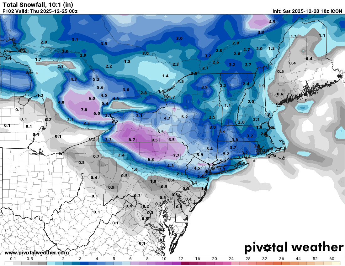
White Christmas Miracle? December 23-24th
Sey-Mour Snow replied to Baroclinic Zone's topic in New England
RGEM went a tad north.. Guidance diverging a bit .. still 72 hours out .. -
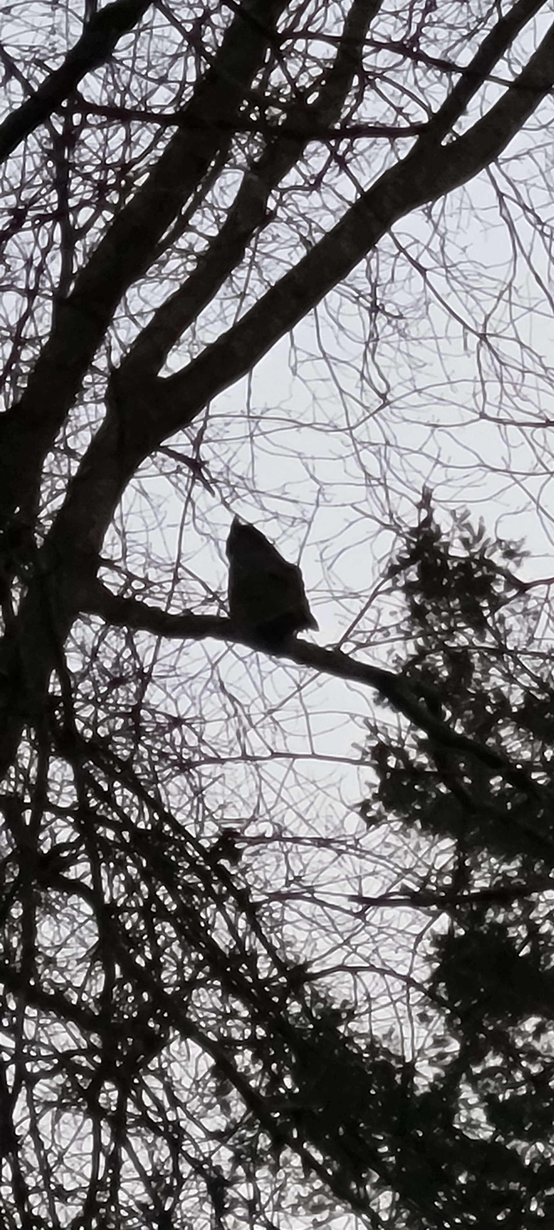
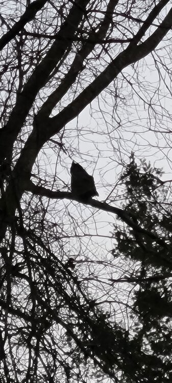
Side note just got home from work and I found 1 of the 2 great horned owls talking in front of my house. While a fox is barking somewhere in the woods behind house.
-
Nws has added the 84.6 wind recorded at montauk point lighthouse at about 36 feet in elevation to the winds. Had to get so much information for them since they didn't have access to weatherlink.
-
White Christmas Miracle? December 23-24th
Sey-Mour Snow replied to Baroclinic Zone's topic in New England
Icon is weird.. Shafts everyone NW of SWCT on Tuesday then gets everyone that missed out Tuesday overnight Tuesday into Christmas Eve with 1-3" -

Possible Light Snowfall (1" - 4") on Tuesday Dec 23
MJO812 replied to Northof78's topic in New York City Metro
Agree -
White Christmas Miracle? December 23-24th
Sey-Mour Snow replied to Baroclinic Zone's topic in New England
I kind of agree with Taunton on this one.. We are going to need 2"+ to have any chance at a White Christmas. Temps look to stay between 33-38 across SNE for about 30 hours between 15z Tuesday and 21z Wednesday, before tanking Wednesday after sunset. Anything under an inch will probably melt. -

White Christmas Miracle? December 23-24th
ineedsnow replied to Baroclinic Zone's topic in New England
18z ICON shifted south also -

Possible Light Snowfall (1" - 4") on Tuesday Dec 23
snowman19 replied to Northof78's topic in New York City Metro
Hot off the presses from NWS Upton. New anticipated Snowfall map: https://www.weather.gov/okx/winter New Disco: A near zonal northern stream flow will predominate through the extended forecast period, except for Wednesday with a ridge building from the Gulf coast states into central Canada. With the near zonal flow temperatures will be generally near seasonal normals, with no cold surges expected. Late Monday nigh a warm front will approach from the southwest, and push through most of the area during the day Tuesday. Light precipitation is likely with the front, and will begin as light snow across the region late Monday night, then as the warm air moves northward, the precipitation will mix with and eventually change to rain, initially along the coast, and then further inland as the day progresses. The warm air may not reach the far inland section, mainly the Lower Hudson Valley, and a rain/snow mix may continue through Tuesday. Bufkit soundings are indicating the possibility of a wintry mix inland as warmer air aloft surges northward. A mix of snow, sleet and freezing rain will be possible. And with the upper levels drying through the day the precipitation becomes light. With the uncertainty in precipitation type, and timing will continue with just a rain/snow mix. High pressure builds into the region for late Tuesday -

White Christmas Miracle? December 23-24th
George001 replied to Baroclinic Zone's topic in New England
This is a Maine storm. -

White Christmas Miracle? December 23-24th
SnowGoose69 replied to Baroclinic Zone's topic in New England
I have not followed it beyond 48-60 with storms so far. I do know its had a bias of being too warm aloft, so basically the reverse of what the HRRR bias is -
White Christmas Miracle? December 23-24th
Sey-Mour Snow replied to Baroclinic Zone's topic in New England
LOL the replacement for NAM and HRRR: RRFS is a toaster bath for most of this forum.. It ticked SW another 35 miles from 12z.. It has 1-3" for SWCT down to central jersey and shutouts everyone else.. RRFS did really good with the last storm, so it has my attention.. It will have to earn our respect though.. -

White Christmas Miracle? December 23-24th
Damage In Tolland replied to Baroclinic Zone's topic in New England
I’m not thinking that’s real this time . Maybe -
White Christmas Miracle? December 23-24th
Sey-Mour Snow replied to Baroclinic Zone's topic in New England
Just wait for the 18z gfs and euro to bring you and TauntonMeh back.. -

December 2025 Short/Medium Range Forecast Thread
Carvers Gap replied to John1122's topic in Tennessee Valley
The Euro Weeklies control had an EPO ridge, NAO, and trough east of Hawaii. -

Possible Light Snowfall (1" - 4") on Tuesday Dec 23
NEG NAO replied to Northof78's topic in New York City Metro
I still think any of these solutions is possible since we are still closer to 60 hours from the event - we are right on the border of the cold enough air and significant enough precip - could go either way....... -

Possible Light Snowfall (1" - 4") on Tuesday Dec 23
eduggs replied to Northof78's topic in New York City Metro
The RGEM wasn't further north. The shortwave was actually a hair south. But lighter precipitation and different distribution of precipitation screwed the impression. ICON and RRFS highlighting the potential for a narrow area of heavier banding. Some indications of possible 0.1" liquid per hour. It probably wouldn't last too long as it shifts east, but it could put down a quick couple of inches if we're lucky. -
December 2025 Short/Medium Range Forecast Thread
Carvers Gap replied to John1122's topic in Tennessee Valley
The control run of the Weeklies looked like this…the best run of the season for the control, -
Nice to have the lawn back. Back to have a catch with the kids, etc
-
Yeah, I saw a big dust cloud towards Boulder driving up to Thornton on 25 yesterday, but winds throughout most the metro area were pretty weak.
-
Very persistent pattern. Something similar has happened before...1917 had an insanely warm and persistent pattern for the PNW/West. This one just looks a bit warmer and more persistent. Don't tell the residents of Juneau, Fairbanks, or Whitehorse that this is what future Decembers will look like. All three are on track for one of their coldest Decembers on record.
-
Possible Light Snowfall (1" - 4") on Tuesday Dec 23
MJO812 replied to Northof78's topic in New York City Metro
Icon
-
As shocked as I was when the sun came up this morning
-
December 2025 Short/Medium Range Forecast Thread
Carvers Gap replied to John1122's topic in Tennessee Valley
FWIW, the Euro control Weeklies looked just fine…even bullish on cold. -
We haven't had any particularly good setups for snow this late fall and early winter and yet there have been several accumulating snow events, particularly for NW areas. It's a little frustrating to not have any bigger events to track, but I must admit December has felt pretty wintry compared to recent years. Maybe that continues early Tue... There are some indications of a pretty good burst of snow with cold antecedent conditions. That would continue the trend of sneaking accumulating snow out of a marginally favorable setup.