All Activity
- Past hour
-

The “I bring the mojo” Jan 30-Feb 1 potential winter storm
SnowHabit replied to lilj4425's topic in Southeastern States
Winter Storm Watch issued just before 3am…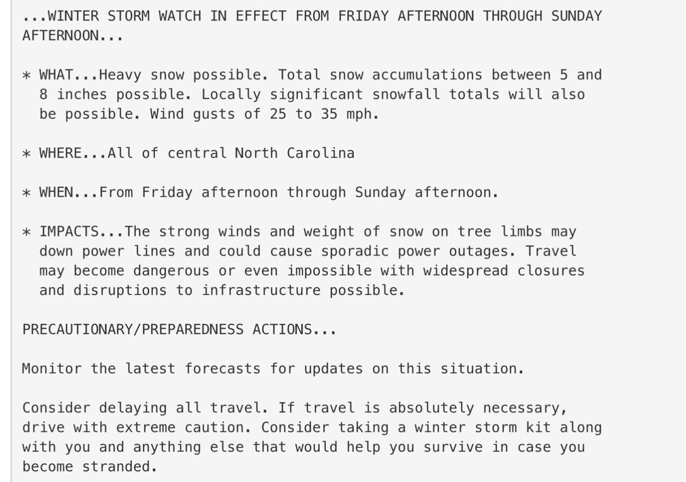
-
.thumb.jpg.6a4895b2a43f87359e4e7d04a6fa0d14.jpg)
Central PA Winter 25/26 Discussion and Obs
Yardstickgozinya replied to MAG5035's topic in Upstate New York/Pennsylvania
I wouldn't say there's no chance. I think if enough gather in song and prayer, we still reel this one in. -

The “I bring the mojo” Jan 30-Feb 1 potential winter storm
BornAgain13 replied to lilj4425's topic in Southeastern States
Winter Storm Watch here. Forecast is for 4-8". -

The “I bring the mojo” Jan 30-Feb 1 potential winter storm
USCG RS replied to lilj4425's topic in Southeastern States
Current projections showcase that this is likely to be Central & Coastal Carolinas Bullseye. That withstanding, the storm is evolving and if the storm closes off a touch more quickly, it could nail the entire subforum essentially. The Euro showcases this, though Eastern GA is still on the cusp with that. -

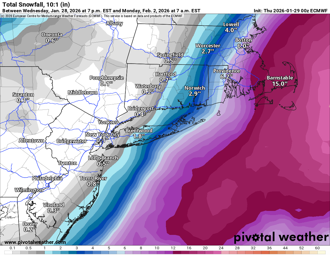
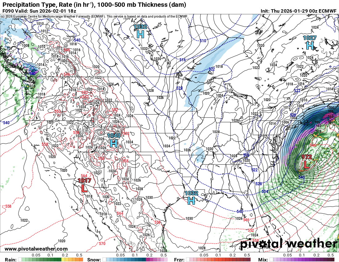
Possible coastal storm centered on Feb 1 2026.
bristolri_wx replied to Typhoon Tip's topic in New England

-

The “I bring the mojo” Jan 30-Feb 1 potential winter storm
AJF0602 replied to lilj4425's topic in Southeastern States
Winter Storm Watch here in Jacksonville, mhx stating 8-12 inches. -
The “I bring the mojo” Jan 30-Feb 1 potential winter storm
USCG RS replied to lilj4425's topic in Southeastern States
Winter Storm Watches issued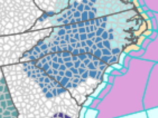
-
SREF is better.
-

The “I bring the mojo” Jan 30-Feb 1 potential winter storm
IceQueen706 replied to lilj4425's topic in Southeastern States
Winter Storm Watch issued by GSP for Rabun County. Reading their forecaster discussion, said QPF decreased some and 2-4" for us on western CWA. I'm happy with 2-4", but was somehow thinking it was more than that. -

The Jan 31 Potential: Stormtracker Failure or 'Tracker Trouncing
TSSN+ replied to stormtracker's topic in Mid Atlantic
This guy is horrid -

Possible coastal storm centered on Feb 1 2026.
DavisStraight replied to Typhoon Tip's topic in New England
Go long frozen concentrated orange juice. -

Possible coastal storm centered on Feb 1 2026.
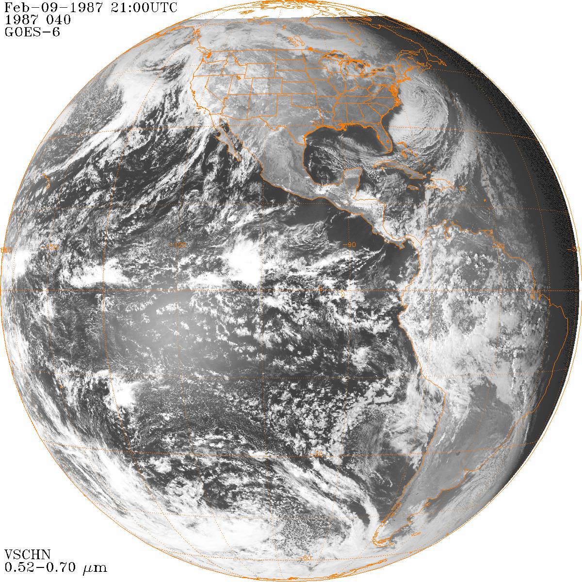
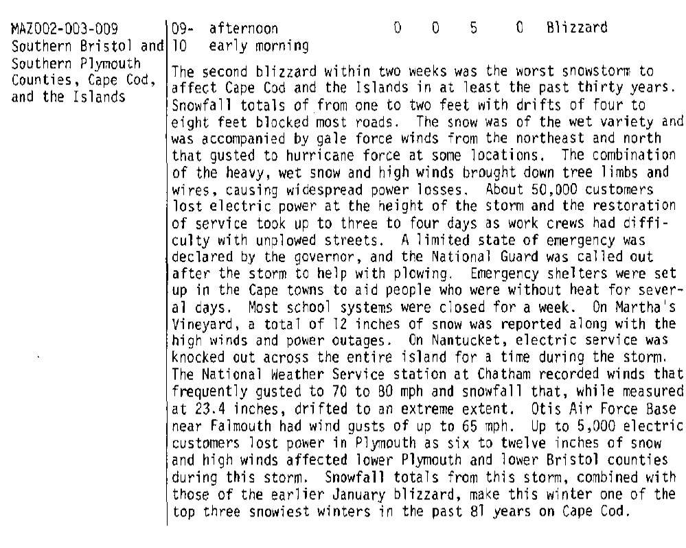
vortex95 replied to Typhoon Tip's topic in New England
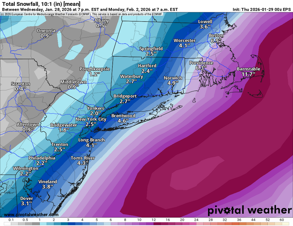
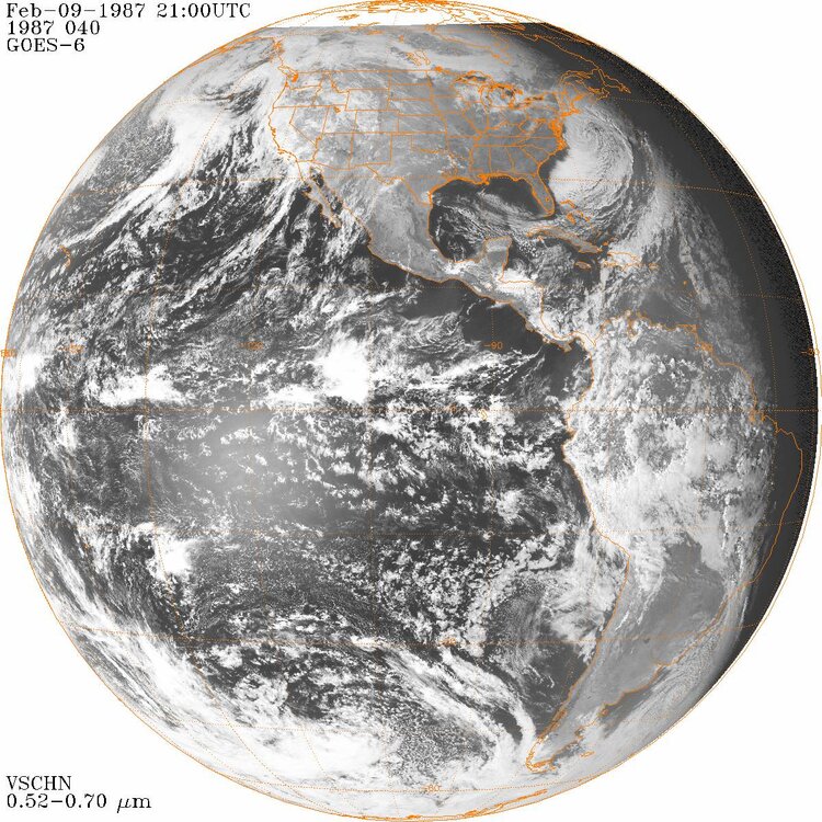
An atypical thing about this storm, it deeply occludes rather far S for a coastal storm (~35N) and has multiple low centers strung out SW to NE, so you will have a huge swath of heavy precip NW of the center, pivoting slowly. How much this pivot is obviously is key (pivotal!?). It can be one of those things, once you are in it, you are in it for awhile, yet not to far NW, just internment flakes in a dry stiff wind. So very sharp snowfall gradients as possible. Among the best snowfall gradient storm for eastern MA occurred 2/9/1987. I got 2" in Woburn MA w/ no real wind, and CHH had 23.4" w/ frequent gusts 60-70 kt. Second Cape Cod-only blizzard in two weeks! A 7-year old CoastalWx was NOT happy! But I was not either, even though 1986-87 was a good winter (only one from 1984-85 to 1991-92), it could have been *much* better!

-
Yeah 2 models have trended west so far,we keep forgetting that a 30 to 60 mile swing northwest gets us in to the good snows.
-
0z canadian def trended west. It gets us in to the light snow.
- Today
-
When the trend is your friend.
-

Possible coastal storm centered on Feb 1 2026.
Roger Smith replied to Typhoon Tip's topic in New England
Buy citrus soon, prices will skyrocket next week. (Florida freeze coming) -

February 2026 Medium/ Long Range Discussion: Buckle Up!
Maestrobjwa replied to Weather Will's topic in Mid Atlantic
Came in here to talk about the same thing...like bruh whhhyyy? Lol (If it does end up looking like that we'll know this time to ignore the threat altogether! -
The Jan 31 Potential: Stormtracker Failure or 'Tracker Trouncing
Roger Smith replied to stormtracker's topic in Mid Atlantic
I was reading about the Washington and Jefferson snowstorm of Jan 28, 1772, apparently both of those esteemed gents were weather watchers and measured 30 inches of snow at both of their locations. There were some gnarly winters around the Revolutionary War period, Jan 1780 was extremely cold and the Hudson River froze over solid. A reading of -16 F was taken somewhere near New York City. That image earlier in the thread reminded me of these factoids. Other winters of the early years that were very harsh were 1805 and 1821. They had dud winters in those times too, a weather journal from Rhode Island shows that winter 1833-34 was very mild and almost without snow. Winters of the 1850s were very cold and snowy but the 1840s were much more variable. In this era of human-modified climate some may forget that there are large natural variations in the mix as well. -
sounds like right in front of the garage is a good place to dump snow for next time
-
It doesn’t need much of a jog west. .
-
.thumb.png.4150b06c63a21f61052e47a612bf1818.png)
Possible coastal storm centered on Feb 1 2026.
HIPPYVALLEY replied to Typhoon Tip's topic in New England
Something different from what the models are showing right now is going to happen for sure. I’m not convinced it will be big for us, but they are definitely going to be some surprises over the next 48 hours. -

Possible coastal storm centered on Feb 1 2026.
George001 replied to Typhoon Tip's topic in New England
I’m not buying this eastern trend at all. Something big is going to happen this weekend. -

Richmond Metro/Hampton Roads Area Discussion
eaglesin2011 replied to RIC Airport's topic in Mid Atlantic
Imo I would rather the storm just blows up farther south in NC & the precip field expands north.. I’d rather just have a nice average 3 to 6 snowfall then have this move more north but the development hurt us and send dry air into this specific area… I think that is what the models are having a hard time predicting… -

The “I bring the mojo” Jan 30-Feb 1 potential winter storm
Snowncanes replied to lilj4425's topic in Southeastern States
Yeah… I think it’s overdoing it though. CAM’s will probably resolve it better but I feel like a low that strong is going to throw precip back. And if we can get even just a slightly earlier negative tilt it will help transfer the energy earlier and throw the precip back over the piedmont better. The gap is from the ULL snow and the energy skipping over and then the low bombing out and so that area misses the brunt of the ULL and of the coastal. -
Possible coastal storm centered on Feb 1 2026.
HIPPYVALLEY replied to Typhoon Tip's topic in New England
Verbatim, would get some accumulating snow pretty far west.