All Activity
- Past hour
-

November 2025 general discussions and probable topic derailings ...
dendrite replied to Typhoon Tip's topic in New England
#neverforget IMG_7041.mov -

2025-2026 ENSO
donsutherland1 replied to 40/70 Benchmark's topic in Weather Forecasting and Discussion
2009-10 was a strong El Niño. 2010-11 was a strong La Niña.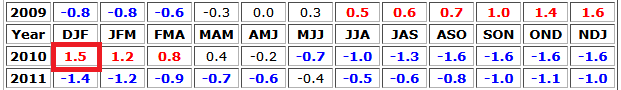
-
I think it would if it wasn’t so marginal in like 100+ millibar layer. I suppose that at the height it could flip to a 33F paste if it’s really really pounding. I just go back in saying bring me those runs from yesterday.
-
Absolutely correct.
-

December 2025 regional war/obs/disco thread
weatherwiz replied to Torch Tiger's topic in New England
The only thing I think Scott tossed was just the snow maps. -

December 2025 regional war/obs/disco thread
Ginx snewx replied to Torch Tiger's topic in New England
I am hoping for heavy rates to wash out minor 850 925 plus .2s -
November 2025 general discussions and probable topic derailings ...
dendrite replied to Typhoon Tip's topic in New England
34° -SN Getting heavier -
December 2025 regional war/obs/disco thread
weatherwiz replied to Torch Tiger's topic in New England
That's right...when was he coming back again, Early Dec? -
No, I definitely didn’t do that. I was looking at the 6z euro and that was my interpretation. It was mild in the boundary layer.
-
That’s the real killer here because if there was more sea ice, then it definitely would’ve been colder and northern Canada, which bleeds down to the rest of Canada and is the source region for the Northeast’s cold air. With such a low arctic sea ice, it limits the amount of cold air that can be tapped into in the northeast and that ends up screwing over locations along the coast until climatology becomes cold enough later in December and January. That’s just one of the many reasons why Tuesday’s storm will likely be rain from most south of I 84 because they’re simply isn’t enough cold air around.
-
.thumb.png.4150b06c63a21f61052e47a612bf1818.png)
First Winter Storm to kickoff 2025-26 Winter season
HIPPYVALLEY replied to Baroclinic Zone's topic in New England
Or whiff. Goalposts set tomorrow, I think it’s most likely a moderate snowstorm for the interior. I’ll be watching the high to the North and if the models start leaning stronger or weaker system. Euro AI had me slightly spooked but we’ll see. -
2009-2010 strong la nina *
-
December 2025 regional war/obs/disco thread
Ginx snewx replied to Torch Tiger's topic in New England
Jerry is in Chicago -
December 2025 regional war/obs/disco thread
Ginx snewx replied to Torch Tiger's topic in New England
I get it totally. Just trying to pull out of you why you tossed the 6z Euro and Ens in favor of the GFS -

Pittsburgh PA Fall 2025 Thread
Rd9108 replied to TheClimateChanger's topic in Upstate New York/Pennsylvania
Yeah I dont trust that we just miss on the system. Early in the season so any snow is a bonus. Sunday maybe a mess for a bit before the changeover. NAM shows it barely getting above freezing when the best precip is in the area. We know how the warmth always seems to win though. -
December 2025 regional war/obs/disco thread
weatherwiz replied to Torch Tiger's topic in New England
Unrelated but should be a nice hefty band of heavy snow that materializes and gets Des Moines, Cedar Rapids, and probably even Chicago. Smack in the middle of the day too...travel will be a nightmare out that way. -
I believe @GaWx had a detailed post about the benefits of a favorable phase(s) closer to the COD, versus high amplitude.
-
December 2025 regional war/obs/disco thread
Ginx snewx replied to Torch Tiger's topic in New England
Moisture from bodies of water or existing precipitation is essential to raise the dew point temperature and saturate the boundary layer. Convective Available Potential Energy (CAPE): Snow squalls are convective events, and CAPE is a significant discriminator between squalls and other snow events. Higher CAPE values indicate a greater potential for deep vertical growth. Time of occurrence: Because they are convective, snow squalls most often happen during daylight hours, with 69% of events occurring between 1300 and 2300 UTC. Radar parameters Reflectivity: Snow squalls typically show reflectivity values greater than 30 dBZ. Radial velocity: Maximum radial velocities in excess of 30 knots are another indicator. Atmospheric parameters Isallobaric effects: Strong surface isallobaric (pressure rise/fall) couplets, combined with steep near-surface lapse rates, contribute to the conditions that produce a squall. 0–2 km layer: The stability of the 0–2 km AGL layer is a factor in snow squall development. -

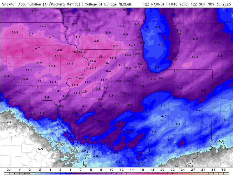
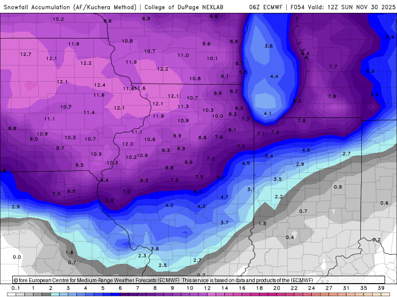
Nov 28-30th Post Turkey Day Wintry Potential
Sciascia replied to Chicago Storm's topic in Lakes/Ohio Valley
Happy Black Friday to those that celebrate with their wallets! Here’s just a brief run-down of Kuch maps from recent model runs: 12z HRRR, 12z 4K NAM, and 6z Euro.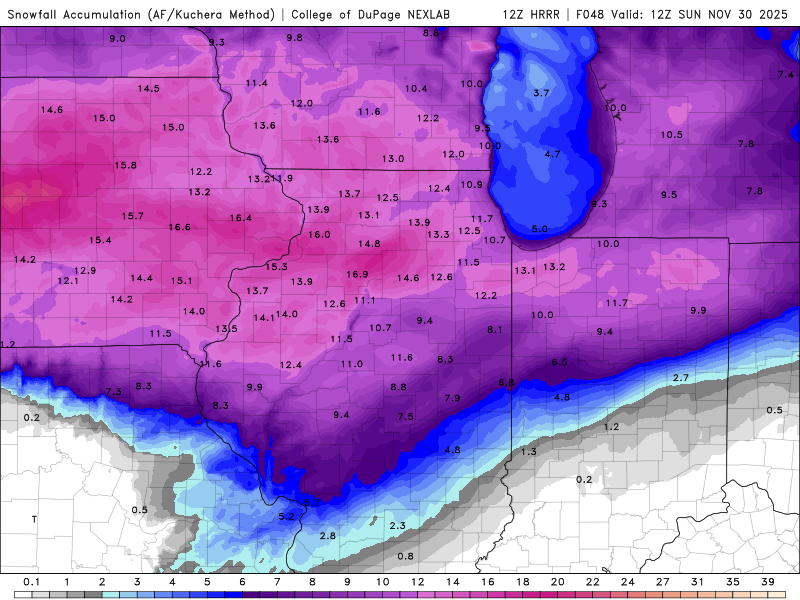
-

Central PA Fall Discussions and Obs
Voyager replied to ChescoWx's topic in Upstate New York/Pennsylvania
I legit lol'd at this one...
-

First Winter Storm to kickoff 2025-26 Winter season
Modfan2 replied to Baroclinic Zone's topic in New England
And here it is, kiss of death, rains to Maine! -
Kinda like one of those streamers with a little bit of convergence coming in with a weak surface trough. I guess more like a cold front. The other day when I looked, it seemed fairly dry, but I think Steve posted a model that showed some snow showers.
-
Hope 12z euro comes back. All I was saying, is that if I put my forecast hat on… It looked dicey down there even under the heaviest stuff. Trust me, there’s nobody else on this planet who wants things to break right more than me.
-
Central PA Fall Discussions and Obs
Voyager replied to ChescoWx's topic in Upstate New York/Pennsylvania
My grandfather used to say, "don't piss this a way", Piscataway..." Anyway, one inch or six inches, it looks like at least most of us see accumulating snow on Tuesday. -

2025-2026 ENSO
PhiEaglesfan712 replied to 40/70 Benchmark's topic in Weather Forecasting and Discussion
I'm not sure exactly what is causing the warmer WPAC ocean temps. All I know is that something must have happened in between the 2009-10 strong el nino and the 2015-16 super el nino.


