All Activity
- Past hour
-

September 2025 OBS-Discussion centered NYC subforum
PhiEaglesfan712 replied to wdrag's topic in New York City Metro
We're overdue for a 100-degree heat wave in late August/early September. We haven't had one since 1953. -

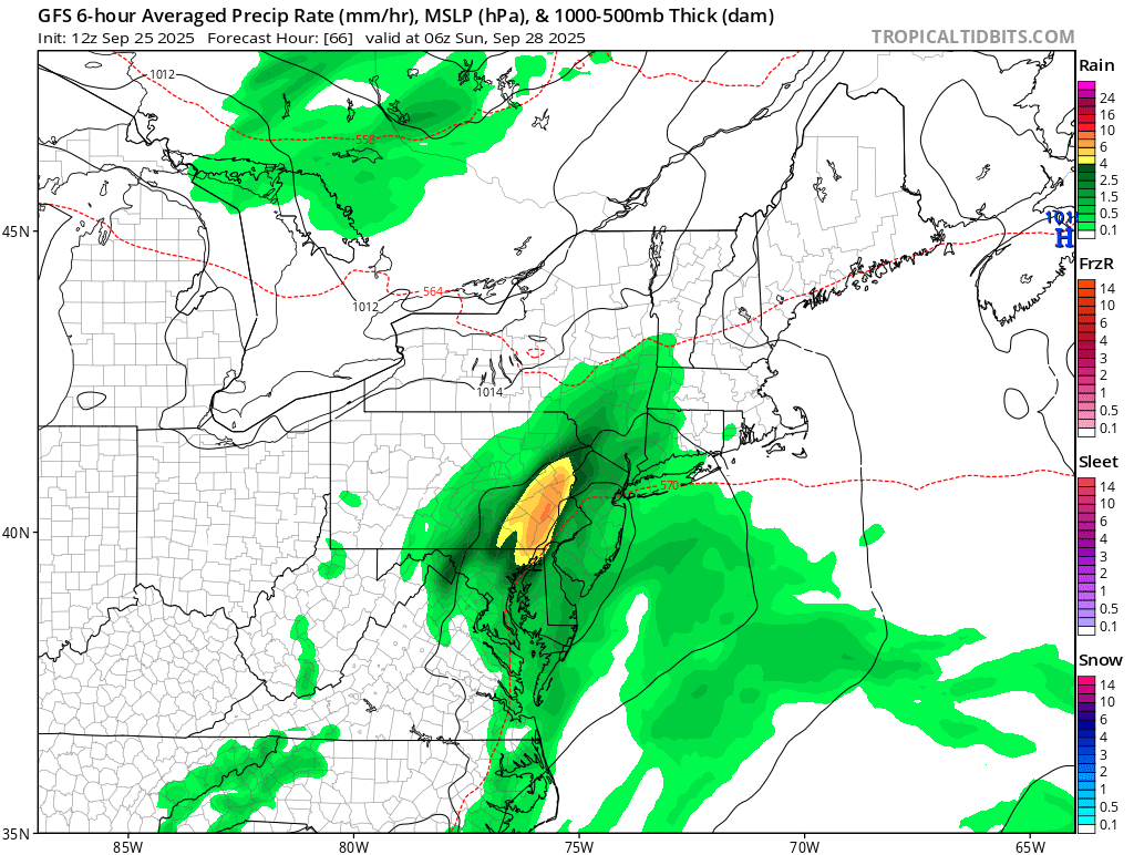
September 2025 OBS-Discussion centered NYC subforum
WeatherGeek2025 replied to wdrag's topic in New York City Metro
GFS is a rainstorm I just checked.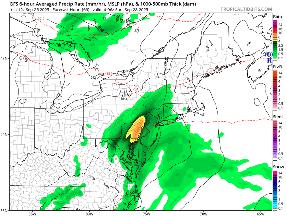
-

September 2025 OBS-Discussion centered NYC subforum
FPizz replied to wdrag's topic in New York City Metro
GFS dry. Cmc maybe a shower? -
 One other note that I’ve seen on recent modeling suggests a more favorable pattern for strengthening with a divergent flow aloft and less dry air. Actually somewhat concerned this could be a strong hurricane now. So much has changed over last couple days
 -
 I think as Newman alludes to above it's all about the timing. A faster system will be more of a NC/VA threat, the slowest solutions gets pulled OTS and somewhere in between makes that left hook into SC as it feels the pull of Humberto just a little bit. That is the most delicate balancing act so I agree it is probably the least likely.
 -
Bring it!
-
Rotating storm in W CT
-
This is more long range speculation, but I do wonder if there’s a chance of remnants or something if the vorticity gets pushed back OTS after the original landfall. 00z euro and 12z gfs hint at it, but obviously that’s weenie range.
-
Pouring concrete early next week in Howard County. Hope it doesn't rain too much.
-

Occasional Thoughts on Climate Change
donsutherland1 replied to donsutherland1's topic in Climate Change
As much of the scientific community sees it, the speech openly mocked the First Law of Thermodynamics, the quantum mechanics of molecular absorption, and the established concepts of radiative forcing and planetary energy balance. Trump dismissed these fundamental laws of physics, and the principles derived from them, as a “scam,” a “hoax,” and “the greatest con job ever perpetrated on the world.” History will record this repudiation of evidence as among humanity's worst policy excesses. They will mark this speech as an iconic moment where comfort in falsehood outweighed the responsibility to truth and raw ignorance uprooted scientific understanding. They will see this moment as a vivid symptom of a Great Denial: a period when humanity still had real power to avert a return to mid-Pliocene or worse conditions yet chose to perpetuate the profitability of industries responsible and policy paralysis instead. They will place such rhetoric alongside the campaigns that once denied the link between tobacco and lung cancer or between CFCs and ozone depletion, citing it as evidence that many, including those in positions of authority, preferred tribal loyalty and ideology over science, evidence, and truth. Future generations condemned to endure the realities of a mid-Pliocene climate will condemn those who consigned them to an unmanageable world. No political gimmick will change the physics. There are no instant, magical methods to draw down the accumulated greenhouse gases, reverse the radiative forcing, or reglaciate the ice sheets that have already disappeared, much less the much greater damage that will occur in decades and centuries ahead. -

-

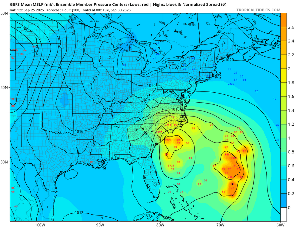
Invest 94L—70% 2 day and 90% seven day odds of development
Newman replied to WxWatcher007's topic in Tropical Headquarters
The trend in the forward motion of 94L is perhaps one of the biggest changes in the past day or so. The GFS went from having it buried in the Bahamas late Sunday/early Monday to being 12 hours away from a Carolinas landfall at that same time. This has certainly helped with the questions regarding interactions between 94L and Humberto. Such a faster 94L eliminates really any fujiwhara conversations. But, we are still within the 4-5 day range where I wouldn't take much off the table yet, other than perhaps a northern Mid-Atlantic and New England hit with such strong confluence present up there
-
Heading to Ocean City after work today for the musical festival. Glad I am packing a poncho, looks like I’ll get rained on occasionally all weekend
-
I know I should be thankful that there is no longer a direct threat to us from whatever 94L becomes, but boy was I hoping for it. :/
-
 12z gefs mostly into SC or NC, though haven't seen past hr 108
 -
Excited?
-
Probably 3-5" between yesterday and today.
-
Humberto with some deep convection recently. Hurricane status can't be far away.
-
 I was just going to post—no surprise being just over 100 hours out but the GEFS essentially follow the op but with more of a NC threat. Everything is still on the table but I’m not convinced this hooks well into SC. I think that’s an unusual track climatologically speaking.
 -
Not something mountain and foothills folks want to see
.thumb.png.cd86f38a195d212abeb0f9bf77b573c8.png)
-

September 2025 OBS-Discussion centered NYC subforum
SACRUS replied to wdrag's topic in New York City Metro
Mid 70s Dew point T's some little breaks of sun in the clouds in spots. -
September 2025 OBS-Discussion centered NYC subforum
SACRUS replied to wdrag's topic in New York City Metro
Euro is wetter (0.50 - 0.75) than gfs (00z/06z) havent seen the afternoon runs yet. -
ICON (trash, I Know) is most wild, gives Bermuda two hits within 48 hours.
-
-

September 2025 OBS-Discussion centered NYC subforum
STORMANLI replied to wdrag's topic in New York City Metro
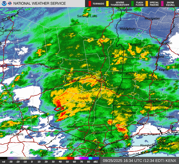
Sullivan County Tornado confirmed by someone on ground. Meanwhile back on LI, after a break in the overcast around 930am, quick- 2-minute- downpour just dropped 0.05", bringing total up to 0.74". Would expect to exceed 1 " here.


.png.a4bf81185d202a212a2cd391c1547073.png)
